
Drygrange, Old Bridge


Road Bridge (18th Century)
Site Name Drygrange, Old Bridge
Classification Road Bridge (18th Century)
Alternative Name(s) River Tweed; Leader Foot; Leaderfoot; Drygrange Bridge; 'tripontium'; Bridge Pool
Canmore ID 55663
Site Number NT53SE 52
NGR NT 57530 34668
NGR Description From NT 57521 34648 to NT 57549 34722
Datum OSGB36 - NGR
Permalink http://canmore.org.uk/site/55663


- Council Scottish Borders, The
- Parish Melrose
- Former Region Borders
- Former District Ettrick And Lauderdale
- Former County Roxburghshire
NT53SE 52 From 57521 34648 to 57549 34722
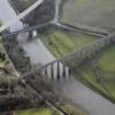
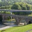
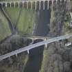
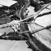
For adjacent railway viaduct and successor road bridge, see NT53SE 76 and NT53SE 77 respectively.
Drygrange Bridge (FB) [NAT]
OS 1:10,000 map, 1992.
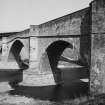
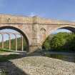
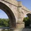
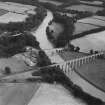
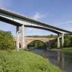
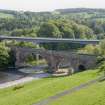
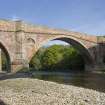
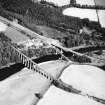
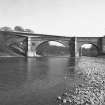
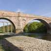
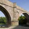
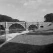
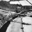
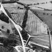
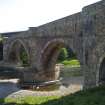
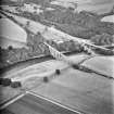
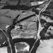
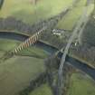
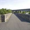
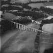
(NT 5753 3467). Drygrange Bridge was built between 1776 and 1780. It crosses the River Tweed in a central segmental archway flanked at either end by a semicircular archway; in addition there is a large arched recess in the S abutment. The cut-waters of the central arch support piers which terminate in angled refuges. The parapets are borne on a rising corbel-course and seem to have been renewed from that level upwards. They bear pyramidal finials at either approach. The roadway is 16ft 5ins (5m) wide above the arches and 25ft 6ins (7.8m) wide at the approaches.
RCAHMS 1956, visited 1951.
(Location cited as NT 576 347). Drygrange Bridge, Leaderfoot. Built 1776-80. A 4-span rubble bridge with a large central segmental arch flanked by two semicircular arches. At the south end is a small semicircular arch, possibly designed as an accommodation arch. From the line of the dentilated string course it appears that the bridge has been raised at the ends to make the carrieageway more nearly level.
J R Hume 1976.
Drygrange Bridge was built by Alexander Stevens in 1777-80, and forms part of the group known irreverently as Tripontium. It has a central span of 31m (exceptional for its date) and an incised plaque at the N end.
C A Strang 1994.
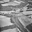
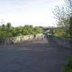
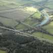
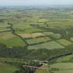
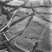
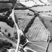
This bridge (which is now closed to road traffic) carries the former line of the A68 (T) public road over the River Tweed a short distance above its junction with the Leader Water.
The location assigned to this record defines the centre of the span. The available map evidence suggests that it extends from NT c. 57522 34647 to NT c. 57550 34721.
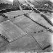
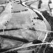
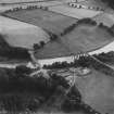
The bridge is visible on vertical air photographs (OS 73/324/003-4, flown 1973.)
Information from RCAHMS (RJCM), 15 October 1997.
Construction (1779 - 1780)
Constructed as a turnpike road improvement. State of the art when built.
Publication Account (1985)
For most of history and prehistory the most important north-south route in south-east Scotland lay through Lauderdale, and around the meeting of the Leader Water and the River Tweed it met its most difficult natural barrier. The Tweed, however, was fordable a little to the west and where the Roman trunk road, later Dere Street, was able to cross the river there grew
up perhaps the most important Roman fort in Scotland, Newstead or Trimontium.
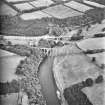
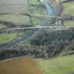
In more recent times the main road and rail routes have followed the coastal route to the east but the A 68 is still a key line of communication to north-east England and the most recent 3-span road bridge stands alongside its predecessor, built between 1776 and 1780 and described in 1798 as that very substantial and elegant [structure] over Tweed at Drygrange, whose middle arch has a span of 105 feet" (32 m).
This rubble-built bridge has 4 spans. Only the large main arch is segmental; it is flanked by smaller semicircular arches with a sizeable arched recess at the southern end. The cut-waters support piers which
terminate in triangular refuges for pedestrians crossing the bridge; and these piers, like the outer walls above the main arch, contain attractive carved decoration. Most prominent are the sculpted urns set within circular panels. From the line of the projecting stone corbels above, it is clear that the parapets have been raised to make for a more level roadway.
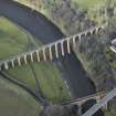
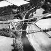
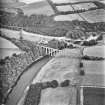
A little to the west stands the tall, graceful, single-track Leaderfoot railway viaduct. Built of an attractive pinkish-red sandstone, its 19 semicircular brick-lined arches rest on slender stone pillars, subsequently reinforced with buttresses. Opened in 1865 for the Berwickshire Railway, and long abandoned, it linked places such as Earlston, Greenlaw, Duns and Chirnside both with the main east-coast line at Reston and with the Waverley route from Edinburgh to Carlisle, just south of Leaderfoot - a route which for largely industrial reasons (the location of the Midlothian coalfield) passed down the valley of the Gala rather than the Leader Water.
Information from 'Exploring Scotland’s Heritage, Lothian and Borders’ (1985).
Photographic Survey (1991)
Project (2007)
This project was undertaken to input site information listed in 'Civil engineering heritage: Scotland - Lowlands and Borders' by R Paxton and J Shipway, 2007.
Publication Account (2007)
Drygrange, or ‘Fly Boat’ Bridge as it used to be known referring to an earlier ferry, is a masonry arch bridge
constructed as a turnpike road improvement in 1779–80 with a central span of 105 ft and two side spans of 55 ft. The rise of the main arch is 34 ft and its arch ring is only 212 ft thick at the crown. The bridge was designed and constructed by Stevens, who applied state-of-the-art practice, including three longitudinal cavities in each spandrel to reduce weight. Its pier foundations are of large hewn stones joined by iron cramps and laid on rock. The cutwaters are of the curved and pointed shape preferred by French engineers but very new to Britain in 1780. The bridge is believed to have been Stevens’ most daring design. For many years, until bypassed in 1974, it carried the A68 trunk road.
R Paxton and J Shipway 2007
Reproduced from 'Civil Engineering Scotland: Scotland - Lowlands and Borders' with kind permission from Thomas Telford Publishers.
Sbc Note (15 April 2016)
Visibility: Standing structure or monument.
Information from Scottish Borders Council

