
Pricing Change
New pricing for orders of material from this site will come into place shortly. Charges for supply of digital images, digitisation on demand, prints and licensing will be altered.
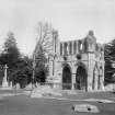
Dryburgh Abbey


Abbey (Medieval), Grave Slab(S) (Medieval), Grave Slab (16th Century), Gaming Board (Period Unassigned)
Site Name Dryburgh Abbey
Classification Abbey (Medieval), Grave Slab(S) (Medieval), Grave Slab (16th Century), Gaming Board (Period Unassigned)
Canmore ID 55618
Site Number NT53SE 2
NGR NT 59158 31703
Datum OSGB36 - NGR
Permalink http://canmore.org.uk/site/55618


First 100 images shown. See the Collections panel (below) for a link to all digital images.
- Council Scottish Borders, The
- Parish Mertoun
- Former Region Borders
- Former District Ettrick And Lauderdale
- Former County Berwickshire
NT53SE 2.00 5915 3167
NT53SE 2.01 NT 5932 3162 Brewery (Possible)
NT53SE 2.02 NT 5919 3201 Lodge
NT53SE 2.03 NT 5931 3181 Lodge
NT53SE 2.04 Centred NT 5910 3175 Burial-ground
NT53SE 2.05 NT 59153 31679 Chapter House
NT53SE 2.06 NT 59103 31633 James I Monument, Obelisk
NT53SE 6 Coffin
(NT 5915 3167) Dryburgh Abbey (NR)
(Premonstratensian - founded AD 1150)
OS 6" map (1967)
Dryburgh Abbey, a house of Premonstratensian canons, was founded on 10th November 1150 by Hugh de Moreville; the alleged foundation charter which attributes the foundation to David I is spurious. It was burned by the English in 1322 and in 1385. It is again reported as devastated by fire in 1461, and was probably damaged again in 1523. The convent, which consisted of at least sixteen canons in addition to the abbot in 1537/8 was reduced to about twelve canons by 1558. It was erected, along with Cambuskenneth Abbey and Inchmahome priory, into the temporal lordship of Cardross in favour of John Erskine Earl of Mar, in parliament, 1604 and 1606 and by charter, 1610 and 1615. (Information from Letters and Papers of Henry VIII, vols.19, 20)
I B Cowan and D E Easson 1976; J Bower 1852; G Robb 1873
Full architectural description given by J S Richardson and M Wood 1948.
Antiquarian Observation (1857 - 1861)
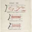
Mason's marks from Scottish churches, abbeys and castles recorded between 1857 and 1861 on 29 drawings in the Society of Antiquaries of Scotland Collection.
Field Visit (May 1914 - December 1914)
258. Dryburgh Abbey.
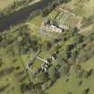
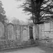
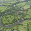
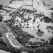
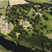
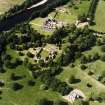
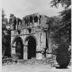
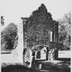
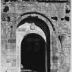
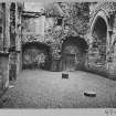
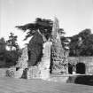
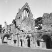
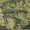
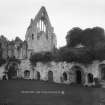
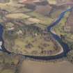
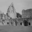
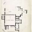
The ruined abbey of Dryburgh stands upon an elevated peninsula formed by a loop of the river Tweed which encircles it on the west and south sides, and is distant about 5 miles to the south-east of Melrose. To the north of the site there is a cruciform church with choir, nave, and transepts. The cloister garth has occupied the lower ground immediately to the south of the nave, having on the east side a range of conventual buildings including ‘St Modan's Chapel’ or the sacristy, the parlour, the chapterhouse, the calefactory, the slype, and another apartment to the south (figs. 123 and 124). The upper floor of this east wing would be used as the monks' dormitory communicating with the south transept in the usual way by means of an open staircase formed at the southwest angle. The refectory probably occupied the south side of the cloister-garth, but owing to the rapid fall of the ground southwards it has been raised to the required level by a basement of vaulted cellars. On the west side of the cloister-garth only three vaulted cellars remain at the north end. A small stream which bounds the Abbey precincts to the south is spanned by a small arched bridge, access to which has been guarded by a gatehouse on the south bank.
[see RCAHMS 1915, pp.132-48, for a full architectural description and historical note]
RCAHMS 1915, visited May: Dec. 1914.
OS Map, Ber., xxx. SW. and SE.
Field Visit (22 February 1961)
As described.
Surveyed at 1:2500.
Visited by OS (WDJ) 22 February 1961
Aerial Photography (1977 - 1978)
Photographed from the air by the RCAHM and by CUCAP (C 6-7, L 26-8, BD 22-5, MT 77-8).
Publication Account (1985)
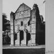
Built of pale, reddish-brown sandstone, the Abbey lies in a horse-shoe bend of the Tweed, several kilometres downstream from Melrose and a little south of the mid 7th century monastic promontory site to St Cuthbert at Old Melrose (NT 588340), well-observed from Scott's View (NT 593342). It was founded by the Premonstratensian Order, brought from Alnwick in 1140. They were a reformed group of Augustinians and this was their first of only six houses in Scotland. As an order they were 'open'-they could go out and serve in the parishes which formed part of their endowment
Though Dryburgh was less troubled than Jedburgh or Kelso, like Melrose it was wasted by the English in 1322, and rebuilt with the financial assistance of Robert the Bruce. Much of what survives today, however, is earlier-of 12th and 13th century date.
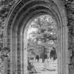
The church comprised an arched nave, short transepts with little chapels on their east sides, and a squareheaded presbytery also with side chapels. Much of the northern transept and its attendant chapels still stands and in St Mary's Aisle are housed the post-Reformation tombs of the Erskines, Haliburtons and Scotts. Sir Waiter Scott is buried here, and nearby, outside the chapel, Field Marshal Earl Haig of Bermersyde.
Like Jedburgh, Dryburgh was of modest height But whilst at Jedburgh the main arcade extended upwards to enclose the triforium-the windowless gallery below the clearstory-here it retains a separate identity, albeit only by being 'squeezed'. It is represented above the transept chapel simply by small openings above each arch.
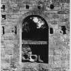
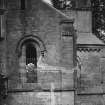
The 15th century west end of the Abbey church lies flush to a high, enclosing cloister wall (where more usually would have been a range of claustral buildings). Elsewhere around the cloisters stood the refectory, warming house, library and vestry, parlour, Novices' day-room, dormitories. The Chapter house, where the monks met daily, contains a fine stone basin decorated with bird-like creatures and some late 12th century painted plasterwork. It has a barrel-vaulted roof and an arched sedilia (priests' seat) along the east wall.
Dryburgh is often thought to be the most romantic of the Border Abbeys. 'Romance' of another strain perhaps is enshrined in an 18th century gravestone just outside the ruined nave. William Forson, whose ancestors were tenants in Drygrange and Redpath Mills for 250 years, was exiled to Ireland for Nonconformity; he returned in 1689 to Holydeanmill where he died in 1748.
Information from 'Exploring Scotland's Heritage: Lothian and Borders', (1985).
Watching Brief (22 July 1998 - 30 July 1998)
NT 5915 3167 A watching brief was conducted in July 1998. A hearth and ruined chimney breast on the floor over the late 12th-century Chapter House were dismantled in order to waterproof the surface. The base of the chimney breast proved to be in situ, probably built in the 16th century when the Commendator's House was built in the ruins of the Dormitory. It was laid on a flaggy surface which may have been an earlier floor level, or the bedding material used to level over the top of the Chapter House vault below, so that a floor could be laid.
Sponsor: Historic Scotland
P Sharman 1998
Kirkdale Archaeology
Excavation (May 2000)
A minor excavation was carried out at Dryburgh Abbey on the 8th of May, 2000 in order to allow a new gravestone to be placed in position. The site of the excavation consisted of the burial ground of the Maxwell-Scott family which is located outside the church in the corner created by the junction of the N transept and the E end of the church.
The plan was to excavate a hole in the SE corner of the burial ground into which concrete would be poured to form a solid foundation for a new gravestone. The exact position of the new stone was intended create a symmetry with an already existing stone in the SW corner of the area. An important proviso concerning this work was that the concrete foundation should not butt directly onto the masonry of the church.
No masonry or finds were exposed during this minor excavation. The lack of major demolition debris in a area of extensive stone robbing suggests the area outside the church walls has been landscaped, with the subsequent removal or disturbance of most, if not all archaeologically sensitive layers in the area of investigation.
Sponsor: Historic Scotland
D Stewart 2000
Kirkdale Archaeology
Trial Trench (December 2002)
NT 591 316 A programme of test trenching was undertaken in December 2002 prior to the laying of an electricity cable to the E of Dryburgh Abbey. This followed previous excavations (DES 2002, 103) which uncovered a variety of medieval and post-medieval archaeological remains.
Both medieval and post-medieval deposits were encountered. Many of these have been interpreted as landscaping, particularly at the N end of the area examined, where the angle of slope varies dramatically either side of the ha-ha. The rich midden material encountered, which demonstrates the excellent survival of bone on the site, may be serving a similar function.
Archive to be deposited in the NMRS.
Sponsor: HS
G Ewart 2003
Excavation (March 2002)
NT 591 316 Nine trenches were excavated in March 2002 to determine the depth below ground level and density of archaeological features at this site. This was done to see if it would be possible to run a drain, or series of drains, along the E side of the structure. Problems have been encountered with standing water externally, and damp internally, which threatens the survival of the plasterwork of the Chapter House.
This series of trenches demonstrated the survival of numerous archaeological deposits immediately below the turf, along the whole E Range of the Abbey. Although the absolute date and significance of some of the features must be uncertain in such small-scale excavations, the discovery of construction trenches for the Abbey walls indicates that at least some of these features must have a medieval origin. The other clearly identifiable features noted at the site were a series of drains, but these seem likely to be relatively recent.
Archive to be deposited in the NMRS.
Sponsor: HS
G Ewart, A Radley and D Murray 2002
Watching Brief (September 2002)
NT 591 316 A watching brief was conducted in August and September 2002 during the replacement of a water main through the environs of Dryburgh Abbey, undertaken to comply with Scheduled Monument Consent. To the N of the house the cut for a ditch was revealed, which was 3.5m wide and filled with jumbled stones and topsoil. The alignment was ESE-WNW and this feature may have been associated with a 14th-century tower house on the site. No other associated remains were seen. To the E, between the Coach House and the Old Corn Mill (NT 53 SE 3) the deposits around and under the trackway were all post-medieval. Abraded glazed and unglazed medieval pottery was recovered from topsoil contexts around Dryburgh Abbey House.
Archive to be deposited in the NMRS.
Sponsor: Northumberland Estates.
I Suddaby 2002
Watching Brief (20 January 2004 - 26 January 2004)
NT 591 316 A watching brief was undertaken in January 2004 while a series of small pits were excavated for the installation of a metal barrier along both sides of the small 'bridge' over the extreme W end of the water channel.
The works caused no significant damage to the masonry of the bridge. The only areas disturbed appeared to be of relatively recent repair, rebuild or rubble infill. Most of the red sandstone masonry and rubble appears likely to have been reused from the ruined abbey. There were no finds of archaeological significance.
A Hollinrake 2004
Sponsor: Historic Scotland
Kirkdale Archaeology
Watching Brief (26 November 2007)
NT 5911 3171 A watching brief was maintained on 26 November 2007 during the removal of a diseased laburnum tree and excavation of a small hole for a replacement tree. The tree was directly against the N boundary wall, some 3m W of where the path and wall meet at the NW corner of the church. The replacement hole’s NE corner was 2.4m W and 2.4m S of this junction. There were no finds or features of archaeological significance.
Archive: RCAHMS (intended)
Funder: Historic Scotland
David Murray (Kirkdale Archaeology), 2008
Watching Brief (26 September 2007 - 28 February 2008)
NT 5914 3170 Work took place to replace a wooden stair connecting the upper floor of the E range with the church and a watching brief was maintained on 26 November 2007 during the excavation of a shallow slot in the S Transept. The slot was just N of the junction of the S and W walls of the S Transept and was needed to take the N end of the new timber stair. The wooden stair can be seen to overlie the scar of a robbed-out stair (presumably stone), contemporary with the Abbey’s use. A stair in this position, connecting the monastic dormitory and the church, is a standard feature of such sites, known as the ‘night stair’.
An irregular line of stones was thought to be the top of the below-ground level footings of the Transept’s W wall. The scars noted on this line of stones probably represent the base of the night stair.
Note: the 'Night Stair' was discovered during the watching brief in November 0f 2007, but was excavated in February 2008.
David Murray 2008
Funder: Historic Scotland
Kirkdale Archaeology
OASIS Id: kirkdale1-60229
Excavation (4 June 2008 - 6 June 2008)
NT 591 316 Following large-scale excavations in 2006, minor excavations were carried out 4–6 June 2008 as part of works to improve drainage near the E range. An underground ‘mole’ was used to dig a drain, at a depth intended to avoid disturbing any archaeological deposits, from the sump and soak-away just S of the Warming House to the ditch to the S of the Novices’ Dayroom.
Three small trenches were excavated, one an extension of an earlier trench at the sump and two on the N side of the ditch where the ‘mole’ was intended to emerge. The sump trench did not reveal any new features beyond those seen in 2006, relating to ‘industrial’ activity during the monastic period. Features in the two ditch trenches were thought likely to be of post-monastic date, associated with late 18th to early 19th-century landscaping.
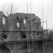
A standing building survey was also carried out to examine the exterior N and E walls of the Chapter House. Evidence suggested the presence of timber structures, including what may have been a substantial timber gallery running around the upper E end of the Chapter House and possibly extending to the N face of the NE tower.
Archive: RCAHMS (intended)
Funder: Historic Scotland
David Murray and Alan Radley (Kirkdale Archaeology), 2008
Watching Brief (15 May 2008)
NT 5912 3170 and NT 5901 3173 Three small trenches were excavated on 15 May 2008, one just inside the nave near the W door and two at the far W end of the Abbey grounds, near the River Tweed.
The two trenches in the grounds were for the relocation of a bench, while the trench in the nave was a shallow
excavation to allow the placement of slabs in an area of erosion next to a notice board. Nothing of significance was seen in the first two, but human remains were found in the nave trench. This burial had been previously disturbed, but both sides of a pelvis in good condition and traces of the coccyx and the base of the spine were still in situ. Bones found in overlying deposits were replaced and the trench backfilled.
Archive: RCAHMS (intended)
Funder: Historic Scotland
Alan Radley (Kirkdale Archaeology), 2008
Watching Brief (16 July 2009 - 17 July 2009)
NT 5915 3172 A watching brief and minor excavation were carried out 16–17 July 2009 during the excavation of a grave in the ruinous N transept of the church of Dryburgh Abbey, just to the W of Sir Walter Scott’s grave and in the Haig family plot. A low stone wall surrounds the S side of this plot, with its N, E and W sides formed from recycled Abbey masonry. A complex sequence of deposits was seen, and although it was difficult to date these, some features may have dated to the monastic period.
Archive: RCAHMS (intended)
Funder: Historic Scotland
David Murray – Kirkdale Archaeology
OASIS Id: kirkdale1-249671
Watching Brief (22 February 2010)
NT 5915 3168
A watching brief was maintained on 22 February 2010 during the excavation of trenches associated with the installation of a power supply to the parlour in the E range of Dryburgh Abbey. The deposits revealed inside the parlour indicated that the present floor is of 19th-century or later date. However, the original floor level may survive beneath the modern floor at a similar depth to the apparently medieval deposits recorded in the exterior trench.
Archive: RCAHMS (intended)
Funder: Historic Scotland
G Ewart and D Murray 2010
OASIS Id: kirkdale1-279223
Watching Brief (15 July 2011)
NT 5914 3172 A watching brief was carried out on 15 June 2011 during the excavation of a small trench for a gravestone in the church of Dryburgh Abbey. An earlier excavation at this location in 2009 (Event ID: 609231) had recorded a sequence of human burials, as well as a mass of disarticulated bone, much of it human. The 2011 excavation revealed the presence of considerable quantities of bone, much of it doubtless human, although there was no indication that any of it was from an in situ articulated burial. This confirmed the findings of the earlier work, which indicated that the site contains a complicated sequence of inhumations, with later burials disturbing earlier ones. The fragments of reddish sandstone recorded were probably derived from the demolished Abbey Church.
Archive: RCAHMS (intended)
Funder: Historic Scotland
Kirkdale Archaeology, 2011
Information also reported in Oasis (kirkdale1-123634) 20 August 2012
Watching Brief (7 June 2011)
A watching brief was carried out during the excavation of three small, shallow trenches for the installation of new signage. There were no features or finds of archaeological significance. In the trench at NT 5912 3165, compacted stone gravel and pebble surface probably represent post-monastic levelling associated with re-landscaping of the monastic ruin.
Information from Oasis (kirkdale1-123467) 20 August 2012
Project (1 February 2017 - 4 February 2017)
NT 59158 31703 A programme of geophysical survey was undertaken, 1–4 February 2017, over c0.8ha covering the southern limits of HES’s property in care area of Dryburgh Abbey, primarily to the S of the extant boundary ditch. Dryburgh Abbey, a house of Premonstratensian canons, was founded in 1150 by Hugh de Moreville. It was burned by the English in both 1322 and 1385. It was subsequently devastated by fire in 1461, and was probably damaged again in 1523. A combination of gradiometer, resistance and ground penetrating radar (GPR) surveys were undertaken.
The gradiometer data are dominated by strong responses throughout the survey area most of which are thought to have a modern or natural origin, although some pit type anomalies and linear trends have also been noted. Within the resistance data there is a series of high and low resistance anomalies suggesting a possible ditch type feature running parallel to and c15m to the S of the existing boundary ditch, although the gradiometer data does not support interpretation of a second ditch. It is possible that the resistance data might indicate a possible track or drove way. However, the resistance response is confusing as it appears to suggest a ‘crossing point’ c30m to the NW of the gatehouse, although the topography of the area would suggest this is highly unlikely. It is assumed that the existing boundary ditch in the W broadly follows an old river terrace, hence the height variation to the N and S of it.
Within the GPR data numerous anomalies have been identified. The majority of these are amorphous and thought to reflect variations in the underlying sands and gravels with some more discrete responses possibly indicating more clearly defined palaeochannels. A possible drainage feature has been detected in the S of the survey area leading to the gate house.
Based on the results of the GPR survey, it seems probable that many of the anomalies recorded in the various geophysical data sets are due to a combination of natural sands and gravels and subsequent ridge and furrow cultivation.
Archive: Rose Geophysical Consultants
Funder: Kirkdale Archaeology on behalf of Historic Environment Scotland
Susan Ovenden – Rose Geophysical Consultants
(Source: DES, Volume 18)
Ground Penetrating Radar (1 February 2017 - 4 February 2017)
NT 59158 31703 A programme of geophysical survey was undertaken, 1–4 February 2017, over c0.8ha covering the southern limits of HES’s property in care area of Dryburgh Abbey.
Ground penetrating radar survey.
Funder: Kirkdale Archaeology on behalf of Historic Environment Scotland
Susan Ovenden – Rose Geophysical Consultants
(Source: DES, Volume 18)
Earth Resistance Survey (1 February 2017 - 4 February 2017)
NT 59158 31703 A programme of geophysical survey was undertaken, 1–4 February 2017, over c0.8ha covering the southern limits of HES’s property in care area of Dryburgh Abbey.
Resistance survey.
Funder: Kirkdale Archaeology on behalf of Historic Environment Scotland
Susan Ovenden – Rose Geophysical Consultants
(Source: DES, Volume 18)
Magnetometry (1 February 2017 - 4 February 2017)
NT 59158 31703 A programme of geophysical survey was undertaken, 1–4 February 2017, over c0.8ha covering the southern limits of HES’s property in care area of Dryburgh Abbey.
Gradiometer survey.
Funder: Kirkdale Archaeology on behalf of Historic Environment Scotland
Susan Ovenden – Rose Geophysical Consultants
(Source: DES, Volume 18)
Field Visit (October 2018)
NT 59175 31709 A small group of 30 medieval stones was assessed in October 2018. They are an addition to the original
inventory, and were discovered during groundworks at the abbey. The stones are typical of the collection as a whole. The
vault rib (DRY/vr/95), with its chamfered outer edges, belongs with the large number of ribs, spingers etc in Phase 1 of the
inventory. These include DRY/as/3, DRY/vk/1, and DRY/vr/1. Possibly because there was a need for very many ribs of this
type in the various abbey buildings including the Warming House and the Novices’ Day Room, it seems that some were begun but not completed or never used within the vaults. They do, however, appear to have been used for sharpening tools, as the incised lines on DRY/vr/96, and DRY/x/38 demonstrate. This and other inventories of carved stones from Historic Environment Scotland’s properties in care are held by the Collections Unit. For further information please contact collections@hes.scot
Mary Márkus – Archetype
(Source: DES Volume 19)
External Reference
EXTERNAL REFERENCE:
R.I.B.A Drawing Collection:
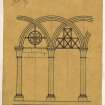
A W Anderson - detail of bays of St Mary's aisle and part plan.
National Library.
Country Life, 7 may 1943 - photograph and information
Uncatalogued MSS of General Hutton Nos 147, 148 - 1 view 1785
- 1 water colour 1789
Mitchell Library
Annan Vol I No. 15 - Photograph of St Catherine's window
Sbc Note
Visibility: Upstanding building, which may not be intact.
Information from Scottish Borders Council

