
Stobs, Barns Viaduct


Railway Viaduct (19th Century)
Site Name Stobs, Barns Viaduct
Classification Railway Viaduct (19th Century)
Alternative Name(s) The Waverley Line; Barnes Viaduct; Border Union Railway
Canmore ID 55164
Site Number NT50NW 25.01
NGR NT 50478 09828
Datum OSGB36 - NGR
Permalink http://canmore.org.uk/site/55164


- Council Scottish Borders, The
- Parish Cavers
- Former Region Borders
- Former District Roxburgh
- Former County Roxburghshire
NT50NW 25.01 50478 09828
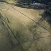
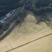
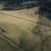
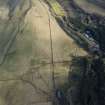
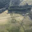
Barnes Viaduct is situated about 100m N of Stobs Station House and spans the Barnes Burn and the minor road leading to Barnes farmsteading. A four arch viaduct with earth embankments formerly carrying a double track railway. It was completed around 1860 by The North British Railway (NBR) as part of The Border Union Railway connecting Hawick to Carlisle.
The viaduct is visible on vertical air photographs (106G/Scot/UK 19, 3402-3403, flown 15 April 1946) and on a later sortie photographed in 1965 (OS/65/4, 307-308, flown 29 March 1965).
Information from RCAHMS
The railway viaduct is owned by Railtrack (formerly British Rail), and access permissions should be sought from them. The RCAHMS photographed the viaduct at deck level from the adjacent property. The deck area has recently been cleared of trees and some repair work carried out to ensure the structure is in a sound condition.
Visited by RCAHMS (DE, AL), 19 May 2010

