
Luffness House


Earthwork(S) (16th Century)
Site Name Luffness House
Classification Earthwork(S) (16th Century)
Canmore ID 55031
Site Number NT48SE 1.02
NGR NT 4748 8038
Datum OSGB36 - NGR
Permalink http://canmore.org.uk/site/55031


- Council East Lothian
- Parish Aberlady
- Former Region Lothian
- Former District East Lothian
- Former County East Lothian
NT48SE 1.2 4748 8038.
(NT 4748 8038) Earthworks (NR)
OS 6" map (1968)
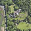
Luffness House stands towards the NW angle of a square fortification defined by a ditch partly filled in. It is hard to say whether this might represent the work raised by the French commander de Thermes in 1549 to block English supplies to their garrison at Haddington (see NT57SW 42), and ordered to be destroyed in 1552, (as suggested by the RCAHMS, and believed in 1853 (Name Book)) or whether it shows the outline of an earlier castle or enclosure as asserted by Tranter (1962), but the former seems more likely.
C McWilliam 1978; RCAHMS 1924, visited 1913
In 1723, the site is described as 'the remains of some old fortifications viz four bastions and two Fusnes (ie fosses or ditches)'.
W Macfarlane 1906
The fortifications round Luffness House are now much wasted by improvements to the grounds. On the S and SE of the house, they are represented by a large irregular L-shaped ditch now overgrown with grass and conifers. To the E of the house are the mutilated remains of two large mounds with an intervening ditch 2.0m deep, and on the W side are the remains of a broad ditch some 2.0m deep, fading out as it approaches the W end of the L-shaped ditch.
Revised at 1:2500.
Visited by OS (WDJ) 21 November 1962
No change to the previous field report.
Visited by OS (SFS) 13 August 1975
Field Visit (3 July 1913)
FORTIFICATIONS.
Round the house at a short distance are the relics of a considerable ditch and of regularly drawn mounds, the lines of which may be seen in the plan given as Fig. 35. These probably represent the camp raised by the French commander De Thermes in the summer of 1549 to block English supplies to their garrison at Haddington (2). In January1552 the fort of Aberlady was ordered by the Queen-Regent and the lords to be delivered to Patrick Hepburn of Wauchton to be cast down and destroyed, ‘except the housis and mansioun thereof’; the artillery to be taken to Dunbar, the mansion and houses to be ‘enjoyed’ by Patrick as his heritage, as his father had done before him (3).Macfarlane in 1723 speaks of ‘some old fortifications viz. four bastions and two Fusnes (sic)’ i.e. fosses or ditches (4).
RCAHMS 1924, visited 3 July 1913.
(2) Cf. Illustrations of the Reign of Queen Mary p.37; (3) Reg. P.C. i. p.119 (4) Geog. Colls. P. 374

