
Mungoswells


Earthwork (Prehistoric)
Site Name Mungoswells
Classification Earthwork (Prehistoric)
Canmore ID 54914
Site Number NT47NE 6
NGR NT 49610 78350
Datum OSGB36 - NGR
Permalink http://canmore.org.uk/site/54914


- Council East Lothian
- Parish Aberlady
- Former Region Lothian
- Former District East Lothian
- Former County East Lothian
NT47NW 6 NT 49610 78350
NT 495 785. 'One, or possibly two, ditches of an oval earthwork measuring externally 320 ft in length by 250 ft in greatest width, in a low-lying pasture field a quarter of a mile due S of Mungoswells'.
RCAHMS Marginal Lands MSS.
There is a mark corresponding generally to the above description on the NMRS 6" at NT 496 783.
(Undated) information in NMRS.
There is nothing visible in a field of newly cut crops.
Visited by OS (BS) 13 October 1975.
Aerial Photographic Interpretation (25 October 1954)
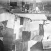
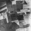
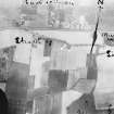
The following remains are visible as crop-markings on a series of air-photographs which were taken by the Royal Air Force in 1930, at the request of the late Dr J Graham Callander, and are now preserved in the Commission’s archives.
Earthwork, Mungoswells.
One, or possibly two, ditches of an oval earthwork measuring externally 320 ft in length by 250 ft in greatest width, in a low-lying pasture field a quarter of a mile due S of Mungoswells.
Information from RCAHMS (KAS) 25 October 1954.
Note (3 December 2015 - 18 May 2016)
Cropmarks have revealed traces of a double ditched enclosure, probably a fort or fortified settlement, in low-lying ground between the canalised burn and a sinuous field boundary marking the parish boundary S of Mungoswells. The cropmarks are not particularly well-defined on any of the photographs, but appear to show an oval enclosure measuring about 100m from ESE to WNW by 55m transversely (0.42ha) within two ditches set about 10m apart; allowing for the presence of an inner rampart, the interior is about 0.35ha in extent. The position of the entrance is not known. While no traces of the ditches remain visible on the ground, the field boundary on the ESE has adopted the outer ditch into its line suggesting that the remains of the enclosure remained upstanding in the medieval period, albeit that the irregular line of the parish boundary may indicate that it originated in a stream channel that preceded the canalised course a little to the W.
Information from An Atlas of Hillforts of Great Britain and Ireland – 18 May 2016. Atlas of Hillforts SC3786

