
Pricing Change
New pricing for orders of material from this site will come into place shortly. Charges for supply of digital images, digitisation on demand, prints and licensing will be altered.
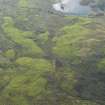
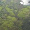
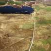
Loch Dulaich


Building (Period Unassigned)
Site Name Loch Dulaich
Classification Building (Period Unassigned)
Alternative Name(s) Loch Dola
Canmore ID 5475
Site Number NC60NW 8
NGR NC 6077 0793
Datum OSGB36 - NGR
Permalink http://canmore.org.uk/site/5475


- Council Highland
- Parish Lairg
- Former Region Highland
- Former District Sutherland
- Former County Sutherland
NC60NW 8 6077 0793.
In Loch Dulaich (NC 607 080) there is an island, the site of a habitation mentioned by Sir Robert Gordon. It is now thickly overgrown.
RCAHMS 1911.
There are three small islands at the S end of Loch Dola; the largest is wooded and the other two covered with rank grass. The islands were not visited, and no information was found regarding the 'habitation'.
Visited by OS (W D J) 29 June 1963.
On the tree-covered, largest island in Loch Dola, at NC 6077 0793, there is a subrectangular earthen mound 12.5m by 10.5m by 0.5m high. There is no trace of walling around or on it. The remains are too indeterminate to classify as the vestiges of a structure; the mound could be a natural feature. The smaller islands to the NW were not visited, but seem to be too low-lying to have been inhabited.
Visited by OS (J B) 8 October 1980.

