
Wester Pencaitland


Fort (Period Unassigned)
Site Name Wester Pencaitland
Classification Fort (Period Unassigned)
Canmore ID 54732
Site Number NT46NW 39
NGR NT 43636 68538
Datum OSGB36 - NGR
Permalink http://canmore.org.uk/site/54732


- Council East Lothian
- Parish Pencaitland
- Former Region Lothian
- Former District East Lothian
- Former County East Lothian
NT46NW 39 NT 43636 68538
Wester Pencaitland. Scheduled with NT46NW 36 as fort and enclosure.
Information from Historic Scotland, scheduling document dated 14 October 1993.
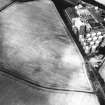
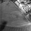
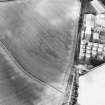
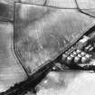
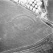
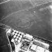
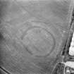
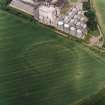
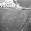
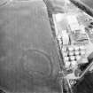
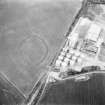
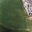
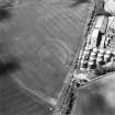
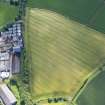
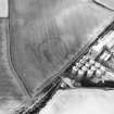
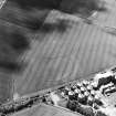
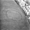
This fort has been recorded as cropmarks on oblique aerial photographs (RCAHMSAP 1979, 1980, 1983, 1990, 1992, 1994, 1995, 2000) and lies on a terrace about 200m WSW of Wester Pencaitland. The fort is roughly circular on plan and measures about 90m in diameter within a ditch about 5m across and a narrower outer ditch. There are entrances on the SW and E.
Information from RCAHMS (KMM) 20 May 2004.
Note (2 December 2015 - 18 October 2016)
This fort or fortified settlement is situated on a low rise immediately S of the the Bairds Malt Ltd storage silos. Oval on plan, it measures 110m from ENE to WSW by 80m transversely (0.69ha) within the inner of two ditches set between 16m and 20m apart. The inner ditch is between 4m and 5m in breadth, and the outer up to 3m, and they are pierced by a single entrance on the ESE. The interior, which is probably slightly dished, appears to contain some areas of deeper sediments and, allowing for the presence of the inner rampart, extends to about 0.55ha. The outer enclosure would have taken in an area measuring about 160m from ENE to WSW by 110m transversely (1.3ha).
Information from An Atlas of Hillforts of Great Britain and Ireland – 18 October 2016. Atlas of Hillforts SC3778

