
Mountmill Burn


Scooped Settlement(S) (Middle Iron Age)
Site Name Mountmill Burn
Classification Scooped Settlement(S) (Middle Iron Age)
Canmore ID 54581
Site Number NT45SE 14
NGR NT 4704 5333
NGR Description NT 4706 5333 and NT 4704 5330
Datum OSGB36 - NGR
Permalink http://canmore.org.uk/site/54581


- Council Scottish Borders, The
- Parish Channelkirk
- Former Region Borders
- Former District Ettrick And Lauderdale
- Former County Berwickshire
NT45SE 14 4704 5333.
(NT 4706 5333 and NT 4704 5330) Enclosures (NR)
OS 6" map (1970)
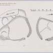
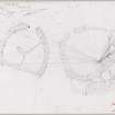
Two enclosures situated at the top of a SE-facing slope. The northernmost is sub-rectangular, measuring 17.0m NW-SE by 16.0m. It is formed by a low turf bank 0.4m high and is slightly scooped into the slope on the NW. There is a narrow entrance in the SE and the interior has vague traces of two small scooped areas. The other enclosure is sub-oval and measures 29.0m NE-SW by 24.0m. It is formed by a mutilated earth-and-stone bank and is scooped into the slope on the W. The bank has a maximum internal height of 0.9m and external height of 0.6m. The interior is divided into two levels by a scarp running NNW-SSE and there are two scooped areas distinguishable on either level. There is a narrow entrance in the NE. The area occupied by the enclosures has been used for quarrying and stone-dumping.
There seems little doubt that these are two scooped homesteads. (Information from K Steer, RCAHMS, 23 November 1954).
Visited by OS (WDJ) 7 January 1965 and (BS) 5 August 1975
Field Visit (29 August 1952)
This site was included within the RCAHMS Marginal Land Survey (1950-1962), an unpublished rescue project. Site descriptions, organised by county, are available to view online - see the searchable PDF in 'Digital Items'. These vary from short notes, to lengthy and full descriptions. Contemporary plane-table surveys and inked drawings, where available, can be viewed online in most cases - see 'Digital Images'. The original typecripts, notebooks and drawings can also be viewed in the RCAHMS search room.
Information from RCAHMS (GFG) 19 July 2013.
Reference (1957)
This site is noted in the ‘List of monuments discovered during the survey of marginal land (1951-5)’ (RCAHMS 1957, xiv-xviii).
Information from RCAHMS (GFG), 24 October 2012.
Sbc Note
Visibility: This is an upstanding earthwork or monument.
Information from Scottish Borders Council

