Pricing Change
New pricing for orders of material from this site will come into place shortly. Charges for supply of digital images, digitisation on demand, prints and licensing will be altered.
Upcoming Maintenance
Please be advised that this website will undergo scheduled maintenance on the following dates:
Thursday, 9 January: 11:00 AM - 3:00 PM
Thursday, 23 January: 11:00 AM - 3:00 PM
Thursday, 30 January: 11:00 AM - 3:00 PM
During these times, some functionality such as image purchasing may be temporarily unavailable. We apologise for any inconvenience this may cause.
Fairneylees
Scooped Settlement (Middle Iron Age)
Site Name Fairneylees
Classification Scooped Settlement (Middle Iron Age)
Alternative Name(s) Fairnylees
Canmore ID 54545
Site Number NT45NE 3
NGR NT 49485 56789
Datum OSGB36 - NGR
Permalink http://canmore.org.uk/site/54545
- Council Scottish Borders, The
- Parish Channelkirk
- Former Region Borders
- Former District Ettrick And Lauderdale
- Former County Berwickshire
NT45NE 3 NT 49485 56789
(NT 4948 5678) Enclosure (NR)
OS 25" map (1967)
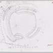
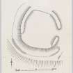
On the edge of the steep left bank of a tributary of the Hillhouse Burn are the remains of an earthwork which has recently been brought under cultivation. Roughly circular on plan, it has measured about 90' in internal diameter, and has been surrounded by a rampart and ditch, both of which are now in a fragmentary state. No trace of the rampart survives on the S side, where it ran along the crest of a natural scarp, some 6' high, and it has similarly been obliterated on the N; elsewhere it is represented by a low earth and rubble mound from 23' to 28' in thickness, but the original breadth of the rampart must have been somewhat less. The ditch, which was originally about 15' wide, is only visible at the SE and SW corners, and in neither case is it more than 18" deep at the present time; at the SW corner it is accompanied by a slight counterscarp mound. There is only a single entrance, some 10' wide, situated in the centre of the E side. The interior, which slopes gently from N to S, has been excavated on the lower side to provide a level floor, but there is no sign of structures.
RCAHMS MSS, visited 1952
This enclosure is as described, but is reduced by cultivation. Sufficient remains to enable it to be classified as a scooped settlement.
Surveyed at 1:2500.
Visited by OS (JTT) 16 December 1964 and (BS) 31 July 1975
Field Visit (26 February 1952)
This site was included within the RCAHMS Marginal Land Survey (1950-1962), an unpublished rescue project. Site descriptions, organised by county, are available to view online - see the searchable PDF in 'Digital Items'. These vary from short notes, to lengthy and full descriptions. Contemporary plane-table surveys and inked drawings, where available, can be viewed online in most cases - see 'Digital Images'. The original typecripts, notebooks and drawings can also be viewed in the RCAHMS search room.
Information from RCAHMS (GFG) 19 July 2013.
Reference (1957)
This site is noted in the ‘List of monuments discovered during the survey of marginal land (1951-5)’ (RCAHMS 1957, xiv-xviii).
Information from RCAHMS (GFG), 24 October 2012.
Sbc Note
Visibility: This is an upstanding earthwork or monument.
Information from Scottish Borders Council


