
Bow Castle


Broch (Iron Age)(Possible)
Site Name Bow Castle
Classification Broch (Iron Age)(Possible)
Canmore ID 54520
Site Number NT44SE 3
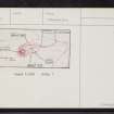
NGR NT 46135 41717
Datum OSGB36 - NGR
Permalink http://canmore.org.uk/site/54520


- Council Scottish Borders, The
- Parish Stow
- Former Region Borders
- Former District Ettrick And Lauderdale
- Former County Midlothian
NT44SE 3 46135 41717.
(NT 4613 4171) Bow Castle (NAT) Broch (NR) (remains of)
OS 6" map (1970)
The Object Name Book of the Ordnance Survey describes ' Bow Castle' as ' The remains of a fortification on Bow Hill. Composed of some scattered stones and earth, the date of its erection or destruction it quite unknown to the inhabitants of the District'.
Name Book 1854
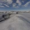
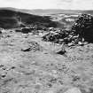
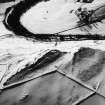
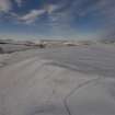
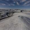
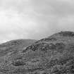
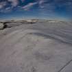
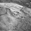
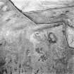
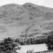
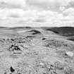
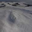
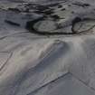
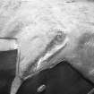
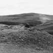
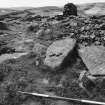
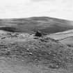
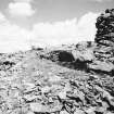
Bow Castle: This broch stands on level ground on the brink of a steep descent SW to the valley of the Gala Water. The ruin of its wall is surmounted by a tall modern cairn built out of the debris. The broch was originally formed by a wall 15ft thick, enclosing an area 31ft in diameter, with the entrance in the NE. It was excavated in 1890 when pottery, including some 2nd century Roman amphora fragments, were found, and in 1922 a 2nd century Roman enamelled bronze brooch in the form of a cock was found among the ruins of the wall. This, and other small finds, are in the NMAS.
R W Feachem 1963; J Curle 1892; 1932; A S Robertson 1970; RCAHMS 1929, visited 1915
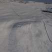
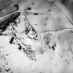
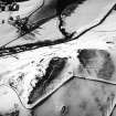
The rubble remains of this broch occupy the summit of a hill. Its wall, 4.5m thick and 0.5m maximum height, encloses a 10.0m diameter court, with an entrance in the E. It has a small modern cairn on its W side.
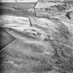
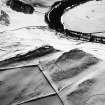
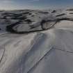
On the gentle slope E of the broch are the slight remains of walls and the occasional scooped area.
Resurveyed at 1:2500.
Visited by OS (EGC) 20 January 1965
Publication Account (2007)
NT44 1 BOW CASTLE
NT/4614 4172
This probable broch stands on level ground on the brink of a steep slope south-west to the valley of the Gala Water (visited in 1989).
Description
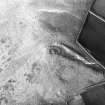
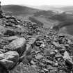
The remains were excavated in 1890 [2] and are now surmounted by a tall modern cairn built out of the debris. According to Curle the circular building has a wall 4.12m (13 ft 6 in) thick, enclosing an area 9.68m (31 ft 9 in) in diameter, with the entrance in the north-east; this wall stood nowhere more that 0.46m (18 in) high. It was observed that “great blocks of stone, which had evidently formed part of the structure, lay piled in confusion on the steep slopes of the hill towards the south and south-west, as though they had been hurled from the summit.” [2, 69]. No intra-mural features were found apart from the very dilapidated entrance on the east.
On the gentle slope east of the broch are the slight remains of walls and the occasional scooped area.
Finds
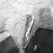
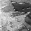
In 1892 fragments of pottery, including some 2nd century Roman amphora fragments, were found in the broch, together with a quern, presumably rotary, and some animal bones which were not identified. A wall sherd of native ware with an elaborate incised pattern was picked up on the site later [2, fig. 2].
In 1922 a 2nd century Roman enamelled bronze brooch in the form of a cockerel was found in the rubble and scree nearby. This and the other small finds are in the NMAS.
Discussion
The few finds, and the brief description of this structure and its exploration, make it difficult to come to definite conclusions, either about its nature or about the end of its occupation. Bow is only a few miles north of the much better understood Torwoodlee (NT43 1) and is likely to have shared the same fate – destruction by the Roman army probably at the beginning of the Antonine period. The tumbled large stones below the site seem to support this idea. The Roman brooch is usually dated to the 2nd century.
If the sherd of incised pottery is indeed associated with the broch it is likely to be a convincing piece of evidence (of a kind lacking from other excavated southern brochs) showing clear contact with Orkney or the Western Isles. This kind of incised pottery is typical of Vaul ware vases in the west but also occurs as a small proportion of the broch pottery of Orkney (see for example Lingro – HY40 2). Such a sherd need not of course indicate that a broch community had come down from the far north or west – the numerous finds from Leckie and Buchlyvie show no real evidence for this – but it could mean significant contact. The most obvious explanation is that a professional broch-builder came from Atlantic Scotland to build the tower at Bow Castle.
Sources: 1. NMRS site no. NT 44 SE 3: 2. J Curle 1892: 3. RCAHMS 1929, 169, no. 233: 4. Curle 1932, 334 and 351: 5. Robertson 1970, Table 1: 6. Macinnes 1985.
E W MacKie 2007
Sbc Note
Visibility: Upstanding building, which may not be intact.
Information from Scottish Borders Council

