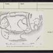
|
Prints and Drawings |
RXD 110/1 |
|
Plans, ink 1":40' RCAHMS 49 Inv. 252, fig. |
1974 |
Item Level |
|
|
Prints and Drawings |
RXD 110/2 |
|
PTS, pencil RCAHMS |
1949 |
Item Level |
|
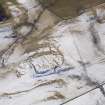 |
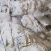
On-line Digital Images |
DP 086191 |
RCAHMS Aerial Photography Digital |
Oblique aerial view of Chester Knowe fort and settlement, looking SSW. |
2/3/2010 |
Item Level |
|
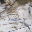 |
On-line Digital Images |
DP 086192 |
RCAHMS Aerial Photography Digital |
Oblique aerial view of Chester Knowe fort and settlement, looking S. |
2/3/2010 |
Item Level |
|
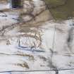 |
On-line Digital Images |
DP 086193 |
RCAHMS Aerial Photography Digital |
Oblique aerial view of Chester Knowe fort and settlement, looking SSE. |
2/3/2010 |
Item Level |
|
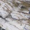 |
On-line Digital Images |
DP 086194 |
RCAHMS Aerial Photography Digital |
Oblique aerial view of the farmstead and Chester Knowe fort and settlement, looking SE. |
2/3/2010 |
Item Level |
|
 |
On-line Digital Images |
DP 086195 |
RCAHMS Aerial Photography Digital |
Oblique aerial view of the farmstead and Chester Knowe fort and settlement, looking NE. |
2/3/2010 |
Item Level |
|
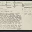 |
On-line Digital Images |
SC 2446601 |
Records of the Ordnance Survey, Southampton, Hampshire, England |
Chester Knowe, NT40NE 1, Ordnance Survey index card, page number 1, Recto |
1958 |
Item Level |
|
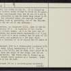 |
On-line Digital Images |
SC 2446602 |
Records of the Ordnance Survey, Southampton, Hampshire, England |
Chester Knowe, NT40NE 1, Ordnance Survey index card, page number 2, Verso |
1958 |
Item Level |
|
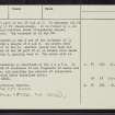 |
On-line Digital Images |
SC 2446603 |
Records of the Ordnance Survey, Southampton, Hampshire, England |
Chester Knowe, NT40NE 1, Ordnance Survey index card, page number 3, Recto |
1958 |
Item Level |
|
 |
On-line Digital Images |
SC 2446604 |
Records of the Ordnance Survey, Southampton, Hampshire, England |
Chester Knowe, NT40NE 1, Ordnance Survey index card, Recto |
1958 |
Item Level |
|
 |
On-line Digital Images |
SC 2446605 |
Records of the Ordnance Survey, Southampton, Hampshire, England |
Chester Knowe, NT40NE 1, Ordnance Survey index card, Recto |
1958 |
Item Level |
|
|
All Other |
551 166/1/1 |
Records of the Ordnance Survey, Southampton, Hampshire, England |
Archaeological site card index ('495' cards) |
1947 |
Sub-Group Level |
|


