
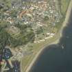
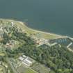
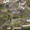
Dysart, Panhall, Shore Road, St Serf's Church


Church (16th Century), Dovecot (Post Medieval)
Site Name Dysart, Panhall, Shore Road, St Serf's Church
Classification Church (16th Century), Dovecot (Post Medieval)
Alternative Name(s) Old Parish Church; St. Serf's Tower; Doocot
Canmore ID 53991
Site Number NT39SW 2
NGR NT 30344 92951
Datum OSGB36 - NGR
Permalink http://canmore.org.uk/site/53991


- Council Fife
- Parish Kirkcaldy And Dysart
- Former Region Fife
- Former District Kirkcaldy
- Former County Fife
NT39SW 2.00 30344 929651
NT39SW 2.01 30360 92946 Churchyard
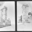
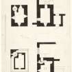
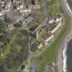
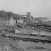
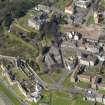
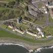
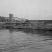
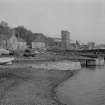
Ruinous. Originally a nave and chancel with aisles, S porch and forti fied SW tower 22.5m high to the parapet; ashlar built, mainly, if not entirely 16th century in date. N aisle has been removed and there are only fragmentary remains of the rest of the church (2 arches on N arcade and 1 of S survive) except for the tower and the porch which are complete.
W Lockhart 1886; D MacGibbon and T Ross 1887-92; 1896-7; J M MacKinlay 1914; RCAHMS 1933.
As described.
Surveyed at 1:2500.
Visited by OS 5 October 1954.
NT39SW 2.00 30344 929651
NT39SW 2.01 30360 92946 Churchyard
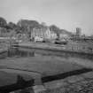
The South-West tower of the old church with fragments of the south aisle and other part of the body of the church.
Non-Guardianship Sites Plan Collection, DC2861.
Field Visit (8 May 1925)
St. Serf's Church.
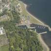
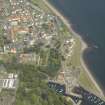
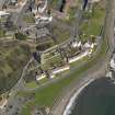
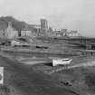
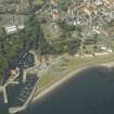
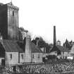
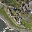
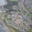
The ruins of this church stand close to the sea, not far from Dysart harbour, and may be identified from a considerable distance by the great western tower (Fig. 254 [SC 1107080]), which rises 74 feet in height from ground to parapet. The church dates mainly, if not entirely, from the early 16th century and has been an oblong of 141 ¾ by 50 feet, comprising a central nave with north and south aisles. The north aisle has been removed, and a road runs over its site, while the nave and south aisle are fragmentary. The western tower is built out from the south aisle, which is unusual but not exceptional, for at St. Giles, Edinburgh, and at St. Michael's, Cupar (NO31SE 15), there were towers similarly placed.
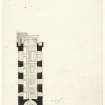
The tower is in alignment with the west gable of the church and there is no discontinuity in the ashlar masonry. It is divided into three unequal stages by string-courses. Externally it measures 29 by 22 ½ feet. In all there are seven floors, each of a single chamber. The two lower floors are vaulted, and the uppermost, which is at the level of the parapet walk, is now a dovecot, while the floor immediately below it is the bell-chamber and has a large pointed-arch window in each wall; on the inner sides of two of these windows are corbels to support the bell-carriages. As the stair-a turnpike at the south-west angle-is narrow, hatches have been formed in the vaults, through which the bells were hoisted. The parapet is borne on separate double-corbels. The turnpike terminates in a cap-house from which there are . two exits to the walk, an unusual provision but probably necessary here on account of wind. The tower has been thoroughly repaired and is in good order.
A porch is fitted in the external angle between tower and aisle. This porch, apparently an addition, is vaulted and is provided with a stone bench on east and south. Above the entrance arch is a late-Gothic niche, evidently intended to contain a figure of the Virgin, since the "pot of lilies" is represented on the corbelled base. Above the entrance to the church is another niche, with an ogival head and a corbelled base, the latter bearing a cherub's head. Within the church on the east of the entrance are the remains of a benatura.
The church has been 135 ½ feet long. The nave and chancel, without the aisles, were 20 ½ feet wide. The whole was covered with a timber roof. In the west gable is a door with a semicircular chamfered head, and above this is the west window, lacking sill and tracery; the gable is crowstepped. The east gable was largely rebuilt when a tomb was inserted within the eastern end of the church, and of the east window merely a portion of one jamb remains. The nave arcade is peculiar in having circular piers set between oblong piers with semi-circular responds. The arches are in two orders, checked and chamfered. Some of the pier capitals are moulded and others are bellshaped; the latter were intended to be carved. The moulded capitals bear some resemblance to the 13th-century capitals of the north transept of Culross Abbey Church (NS98NE 3). The south aisle wall is a patchwork, but traces still remain of windows and doors and these are indicated on the plan.
Near to and south of the old church once stood the chapel of “St. Dennis," on which see New Statistical Account, ix. p. 134.
Cf. also Eccles. Arch., iii, p. 437.
RCAHMS 1933, visited 28 May 1925.
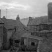
Photographic Survey (October 1964 - November 1964)
Photographic survey of buildings in Dysart by the Scottish National Buildings Record/Ministry of Work in October and November 1964.

