 |
On-line Digital Images |
SC 335748 |
|
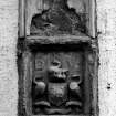
North facade, detail of heraldic plaque |
|
Item Level |
|
 |
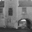
On-line Digital Images |
SC 335749 |
|
View from north of Tolbooth. Includes No.1 - 2 Broad Wynd (49 Main Street). |
|
Item Level |
|
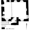 |
On-line Digital Images |
SC 337421 |
Records of the Royal Commission on the Ancient and Historical Monuments of Scotland (RCAHMS), Edinbu |
First floor plan
Preparatory drawing for 'Tolbooths and Town-Houses', RCAHMS, 1996.
N.d. |
|
Item Level |
|
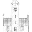 |
On-line Digital Images |
SC 337422 |
Records of the Royal Commission on the Ancient and Historical Monuments of Scotland (RCAHMS), Edinbu |
North elevation
Preparatory drawing for 'Tolbooths and Town-Houses', RCAHMS, 1996.
N.d. |
|
Item Level |
|
 |
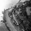
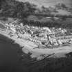
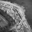
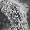
On-line Digital Images |
SC 397802 |
RCAHMS Aerial Photography |
Oblique aerial view from South East. |
1991 |
Item Level |
|
 |
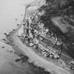
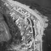
On-line Digital Images |
SC 397803 |
RCAHMS Aerial Photography |
Oblique aerial view from North East. |
1991 |
Item Level |
|
 |
On-line Digital Images |
SC 397805 |
|
13-37 Main Street (odd numbers).
View from South West of Main Street including Tolbooth. |
|
Item Level |
|
 |
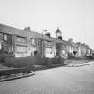
On-line Digital Images |
SC 397806 |
|
2-20 Main Street (even numbers) also 29 and 39.
View from West of Main Street including Tolbooth. |
|
Item Level |
|
 |
On-line Digital Images |
SC 397807 |
|
View from Burns Wynd (North East) of Main Street including Tolbooth. |
|
Item Level |
|
 |
On-line Digital Images |
SC 803920 |
Papers of Professor John R Hume, economic and industrial historian, Glasgow, Scotland |
View from ENE showing ENE front of tower |
1979 |
Item Level |
|
 |
On-line Digital Images |
SC 803923 |
Papers of Professor John R Hume, economic and industrial historian, Glasgow, Scotland |
View from WSW showing WSW front of tower |
1979 |
Item Level |
|
 |
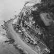
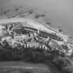
On-line Digital Images |
SC 1672756 |
RCAHMS Aerial Photography |
Oblique aerial view from South East. |
1991 |
Item Level |
|
 |
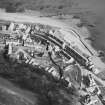
On-line Digital Images |
SC 1672757 |
RCAHMS Aerial Photography |
Aerial view from North East. |
1991 |
Item Level |
|
 |
On-line Digital Images |
SC 1672758 |
RCAHMS Aerial Photography |
Aerial view from North East. |
1991 |
Item Level |
|
 |
On-line Digital Images |
SC 1672759 |
RCAHMS Aerial Photography |
Oblique aerial view from North East. |
1991 |
Item Level |
|
 |
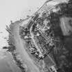
On-line Digital Images |
SC 1672760 |
RCAHMS Aerial Photography |
Aerial view from West. |
1991 |
Item Level |
|
 |
On-line Digital Images |
SC 1672761 |
RCAHMS Aerial Photography |
Aerial view from West. |
1991 |
Item Level |
|
 |
On-line Digital Images |
SC 1672762 |
RCAHMS Aerial Photography |
Aerial view from North. |
1991 |
Item Level |
|
 |
On-line Digital Images |
SC 1672763 |
RCAHMS Aerial Photography |
Aerial view from North West. |
1991 |
Item Level |
|
 |
On-line Digital Images |
SC 1672764 |
RCAHMS Aerial Photography |
Aerial view from West. |
1991 |
Item Level |
|
 |
On-line Digital Images |
SC 1802482 |
Scottish Development Department |
Tolbooth, Main Street, West Wemyss, Wemyss Parish, East Lothian & Kirkcaldy, Lothian and Fife |
20/12/1983 |
Item Level |
|
 |
On-line Digital Images |
SC 2446577 |
Records of the Ordnance Survey, Southampton, Hampshire, England |
West Wemyss, Main Street, Tolbooth, NT39SW 13, Ordnance Survey index card, Recto |
1958 |
Item Level |
|
 |
On-line Digital Images |
SC 2446578 |
Records of the Ordnance Survey, Southampton, Hampshire, England |
West Wemyss, Main Street, Tolbooth, NT39SW 13, Ordnance Survey index card, Recto |
1958 |
Item Level |
|
 |
On-line Digital Images |
SC 2510592 |
|
View from SW of rear of No.s 2 - 20 Main Street. Includes part of Tolbooth. |
27/2/1991 |
Item Level |
|


