
Pricing Change
New pricing for orders of material from this site will come into place shortly. Charges for supply of digital images, digitisation on demand, prints and licensing will be altered.
Inveresk Lodge


Lodge (17th Century)
Site Name Inveresk Lodge
Classification Lodge (17th Century)
Canmore ID 53812
Site Number NT37SW 162
NGR NT 34869 71851
Datum OSGB36 - NGR
Permalink http://canmore.org.uk/site/53812


- Council East Lothian
- Parish Inveresk (East Lothian)
- Former Region Lothian
- Former District East Lothian
- Former County Midlothian
An L plan house with an octagonal stair turret in the angle, one of the windows dated 1683; the wing is slightly later, but the whole was completed by 1700. Interior modernised except for drawing room on the E side, which has early 18th century panelling.
D MacGibbon and T Ross 1889; RCAHMS 1929; R Prentice 1976; C McWilliam 1978
NT37SW 162 34876 71849
NT37SW 162.01 3490 7185 Gardens (watching brief)
NT37SW 162.02 34884 71821 Gardens
NT37SW 162.03 34890 71818 Sundial (Pitreavie Sundial)
NT37SW 162.04 34878 71870 Gateway
NT37SW 162.05 34870 71870 Motorhouse
NT37SW 162.06 34895 71851 Greenhouse
NT37SW 162.07 34851 71840 Outbuilding remains
NT37SW 162.08 c. 34910 71844 Sundial (Inveresk Sundial).
NMRS REFERENCE
Dick Peddie and McKay, Edinburgh additions and alterations
Attic 2, Bin 6, Bag 2 J.R. McKay 1937
Field Visit (18 February 1921)
Inveresk Lodge.
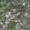
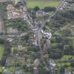
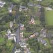
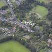
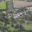
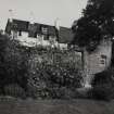
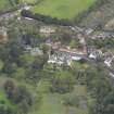
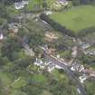
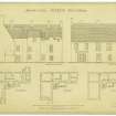
Inveresk Lodge is situated at the south-eastern end of the village of Inveresk, on the south-west side of the highway. The earliest portion of the house dates from 1683, and the whole was completed before 1700. The nucleus was an L-planned structure, comprising a main block, 25 feet broad and 55 feet long, of two storeys and a garret in height, with a wing two storeys, an attic, and a garret in height and 21 feet wide, that projects 15 ½ feet westwards in alignment with the south-east gable. Within the re-entrant angle, which opens to the north, is a semi-octagonal tower containing a turnpike. Shortly after its completion the wing was extended to the north-western boundary of the feu, and from this extension a low range of stabling was run up parallel to the main block; buildings thus enclosed three sides of a courtyard shut off from the road by a boundary wall. Within the re-entrant angle formed by the stair tower and the extension an outbuilding was added in modern times. South-west of the house is a terrace that was at one time occupied by offices, but these, with the exception of two subterranean vaulted cellars, have been removed. The extension of the wing has also been cutback 7 ½ feet; at its present termination the north-east wall has an almost imperceptible swelling, which is all that now denotes the turret stair which formerly rose from the first floor to the garret.
The masonry is of rubble and is rough-cast; the windows have dressed and back-set margins, which in the earlier work are moulded with an edge-roll and quirk, and in the later work chamfered at the arris; the window in the stair tower above the entrance is dated 1683. The attic floor is lit by a series of close-set dormers. The gables are crow-stepped.
The entrance is at the stair foot in the north eastern wall of the tower; the adjoining entrance is a transformed window; the wrought iron knocker, hinges and lock date from the 18th century at latest.
The internal arrangements have been entirely modernised, but the present smoking-room, which lies on the ground floor between the dining- and drawing-rooms, is much in its original state. Its walls are panelled in oak after the early 18th-century mode; behind the panelling was a plaster ground decorated in black or dark grey paint, and on this, while still soft, the plasterer incised the date 1704; the panelling is therefore subsequent to that time.
RCAHMS 1929, visited 18 February 1921.
OS map: Edinburgh iv S.E. (unnoted).
Standing Building Recording (18 January 2011 - 11 November 2011)
NT 34876 71849 A survey of the roof structures at Inveresk Lodge was undertaken, 18 January–11 November 2011, following the localised failure of the roof structure above the double height first floor Music Room, on the eastern pitch of the principal N–S aligned range. The work consisted of a drawn survey of the roof structure, a written record, a photographic survey and a report.
Inveresk Lodge lies on the SW side of Inveresk Main Street towards its SE end. The building occupies the NW corner of a wider plot located on the SE side of the level top of the Inveresk ridge; beyond the building itself the ground then slopes rapidly downhill to the flood plain. The area of ridge to the SE of the house and the sloping ground to the SW form part of the NTS Inveresk Garden.
An initial examination of the roof indicated that it was a complex structure, which had been considerably modified at an early date. The relationship of the main roof to additional roof structures relating to the stair tower and S range, which ran in from the W, were considered of particular interest. These structures appeared to be secondary to the roof structure of the main range, suggesting that the principal range may have been pre-existing. This finding was at odds with an established theory that the original Inveresk Lodge consisted of the main range and the first section of the southern range, forming an L-plan, with the existing semi-octagonal stair tower at the re-entrant, and that the whole was datable to c1683 (on the basis of a dated window lintel on the stair tower). The possibility that the Inveresk Lodge of the 1680s incorporated parts of pre-existing structures had been proposed in the past, though little direct evidence had been cited.
The roof above the principal, eastern range of Inveresk Lodge was a complicated single structure, the product of a number of periods and re-workings. The structure basically consists of 35 couples (cross-frames) arranged at 16 to 18” centres. The surviving original couples are arranged in sequence by numbered carpenters’ assembly marks. These run in an interrupted, though correctly positioned sequence, from I–XXXII. A number, including the last three, have been wholly or partly renewed. The roof is substantial, with a span of c7.6m. Each frame consists of a rafter couple, each morticed, tenoned and pegged at the apex; an upper collar affixed to the upper (N) side of the rafters, this half-lapped with a half dove-tail and pegged; and a lower collar (or tie) that is morticed, tenoned and single-pegged. The lower collars are set at relatively high level for such a span, at about 1.7m above the rafter foot; this was evidently contributory to the structural failure of the roof below.
Parts of the rafter-end assembly were visible at the interior wall face in the S compartment of the roof space. Though the wall head masonry is built up around the rafter feet, short vertical timber sections were visible and these revealed that the rafters terminated at an ashlar-piece/sole-piece assembly, a feature typical of early Scots roof construction. In November 2011 rafter feet were revealed and recorded during repair works at five points in the N compartment of the roof, three on the E pitch and two to the W. The full assembly was revealed in a number of places and added to the survey drawings.
The recording and analysis carried out suggests that even the early part of the building is far more complicated than previously thought. The early roof structure predates work dated to c1683 (the stair tower). Typologically the roof form could be considerably earlier, although details of Scots roofing evolved very slowly and over a long period of time. The possibility of an earlier 17th-century or even late 16th-century date cannot be excluded on the basis of present evidence. The quirked angle roll detail present on some of the E range windows would be somewhat archaic at the end of the 17th century, but is commonly employed in the later 16th and earlier 17th centuries.
Archive: RCAHMS
Funder: The National Trust for Scotland
Addyman Archaeology 2011
Reference (February 2013 - February 2013)
Inveresk Lodge, well situated at the south-eastern end of the village, with its principal façade orientated perpendicular to the main street, overlooking its large gardens. The principal five-bay wing that faces south-east was completed in 1683 (this date based on a dated lintel on the stair tower), with the extension and heightening of the NW wing being completed by the end of the century.
There appears to be little evidence to confirm any pre-1683 structure other than the layout of the NW extension –Green raises this point stating that ‘Inveresk Lodge appears to have been constructed on the site of or incorporating earlier buildings. This would explain the curious angle of the E kitchen wall and related parallel walls’.
According to the RCAHMS Inventory of 1929 the original form of the lodge would appear to have been the ‘main block, 25-feet broad and 55-feet long, of two storeys and a garret in height’, served by an octagonal stair projecting from the NW elevation (at the midpoint of the ‘main block’), with its principal entrance at the base of the stair in the re-entrant angle. The RCAHMS Inventory suggests that the NW wing forming the ‘original’ L-plan extended only as far as the north wall of the scullery, with the aforementioned extension adding further rooms to the NW to connect with a stable range.
The evidence of a former dormer window to the NW corner of the main block, it would suggest that the roof of any ‘original’ NW wing was lower than it is now. This would suggest that if the NW extension was completed by 1700, the roof of the ‘original’ NW wing must presumably have been raised at the same time – but this presents a quandary in that the roofline is not contiguous and clearly dates to different periods. Furthermore, the roof structure in the ‘original’ NW wing differs from the main block, as does the roof structure to the top of the stair. This therefore alludes to the original rectangular form, or more likely, T-plan with projecting octagonal stair serving only the first floor. The first part of the NW wing is therefore a subsequent phase, which rose to the full height of the main block, blocking the aforementioned dormer in the process. This was perhaps coupled with the raising of the stair tower to serve this second floor level and would appear to make sense of the unusual sharp right-hand turn at the top of the stair that leads into the NW wing that has no evidence of a direct entry in to the main block.
Furthermore, although it is known that the combed ceiling to the first floor room (variously referred to as state dining room, drawing room or billiard room), is an early 18th century alteration, there is evidence of plastered walls behind the combe. This suggests not a double-height space, but a two-storey space with the existing garret above – rather than the floor level of the garret having been
raised to increase the height of the room below. The enlarged windows to this grand room have further obscured the original section of the building, but the evidence seems to suggest two storeys, attic plus garret, neatly tying in with the visual arrangement of the NW wing extension and the near contemporary Halkerston with their double lines of dormers.
Many of the interiors date from the 18th century, with subsequent minor alterations in the 19th century including the advanced window of the new dining room on the ground floor (with the state dining room above then becoming a drawing room), and the addition of a full-height extension to the NW of the stair tower.
At some point between 1921 and 1943, the subdivision between the smoking room/entrance hall and drawing room was removed, and the ‘18th century panelling [was] ‘stretched’ round all the walls’. Further alterations carried out in the 20th century included new bathrooms, but not on the scale suggested by the 1937 drawings held by the RCAHMS that proposed a half-octagonal extension to the south end of the SW elevation.
A Historic Building Survey carried out in 2010 on the eastern roof structure of Inveresk Lodge suggests that the Lodge was built up over a number of periods, with the first roof structure comprising the timberwork above the long east range, indicating that the east range is an ‘original core’ of the present Lodge.
That the other elements of the ‘L-plan’ are secondary are suggested by their roof structures. The stair tower roof runs over that of the E range, as does that of the western jamb of the ‘L’. Of the two the stair tower seems to have been erected first, the dated lintel indicating c1683. The early E range thus became a ‘T’-plan. This is further supported by the very noticeable difference in window detail between the early surviving windows of the E range, which have quirked rolls, and those of the stair tower, which are chamfered.
The addition of the western jamb occurred later, and seems to have been associated with a major reordering of the interior of the E wing – the formation of the double-height great chamber, a probable State Dining Room, and creation of associated high status rooms at the S end of the E range and within the new W jamb. The details of these interiors suggest an early 18th century date. A painted date discovered beneath panelling of 1704 may relate to these works.
The Survey suggested that even the early part of the building is far more complicated than previously supposed. The early roof structure pre-dates work dated to c1683 (the stair tower). Typologically the roof form could be considerably earlier. The possibility of an earlier 17th century or even late 16th century date cannot be excluded on the basis of present evidence.
Information from NTS
Standing Building Recording (17 June 2013 - 23 August 2013)
NT 34869 71851 An opportunity arose for a standing building survey of the lodge to be carried out, 17 June – 23 August 2013, when the building became temporarily vacant following a small fire. A measured survey of external and internal elevations, a plan and photographic and written records were produced. A review of archive material was also undertaken.
The work established that several phases of building had taken place within the lodge. The long standing construction date of 1683, based on the date inscribed lintel over the stair tower window, reflects the date of the stair tower, which was added to the original and earlier SE wing. The SW wing was then added, probably in two stages, with later 19th-century additions and changes. One of the major changes to the house was the creation of the Music Room, possibly in the late 18th or early 19th century, from a former two-storey element of the SE wing. Large windows were inserted to the SE elevation, disturbing the balance of the façade. A central doorway with porch and a large dining room extension to the S was also added at this time. The NW wing of the house was demolished during the early 19th century, creating a bulge in the wall on the W side of the NE elevation. There is now a separate block forming the NW wing.
Archive: RCAHMS (intended)
Funder: The National Trust for Scotland
Diana Sproat, AOC Archaeology Group, 2013
(Source: DES)

