
Following the launch of trove.scot in February 2025 we are now planning the retiral of some of our webservices. Canmore will be switched off on 24th June 2025. Information about the closure can be found on the HES website: Retiral of HES web services | Historic Environment Scotland
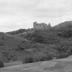
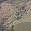
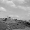
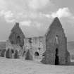
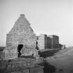
Crichton Castle, The Slaughter House


Graffiti (Period Unknown), Stable (Period Unassigned)
Site Name Crichton Castle, The Slaughter House
Classification Graffiti (Period Unknown), Stable (Period Unassigned)
Alternative Name(s) Crichton Castle, Stable Block; Crichton Castle, Chapel (Possible)
Canmore ID 53602
Site Number NT36SE 7.01
NGR NT 38008 61088
Datum OSGB36 - NGR
Permalink http://canmore.org.uk/site/53602


First 100 images shown. See the Collections panel (below) for a link to all digital images.
- Council Midlothian
- Parish Crichton
- Former Region Lothian
- Former District Midlothian
- Former County Midlothian
NT36SE 7.01 38008 61088
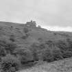
(NT 3801 6107) The Slaughter House (NR)
Ruins of Chapel (NR) (Supposed)
OS 6" map, Midlothian, 1st ed., (1852).
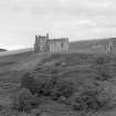
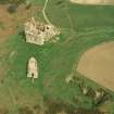
This building has all the appearance of an old chapel. It is not known locally what its purpose was; some say it was for the accommodation of visitors' retainers, others suppose it was for keeping cattle.
Name Book 1852.
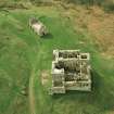
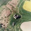
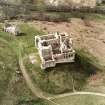
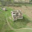
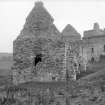
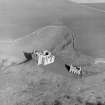
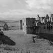
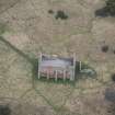
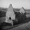
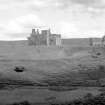
This roofless building was a stable, with quarters for the grooms overhead. The buttressing is an afterthought. There are foundations of other outbuildings nearby.
W D Simpson 1957.
A ruined building, of uncertain purpose, as described.
Visited by OS (BS), 24 October 1975.
Field Visit (2 September 1920)
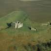
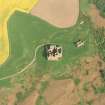
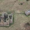
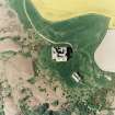
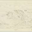
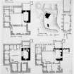
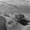
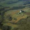
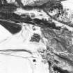
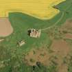
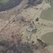
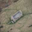
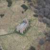
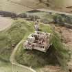
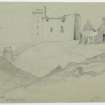
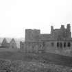
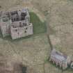
OUTBUILDING. The outbuilding (Fig. 79) is an oblong structure of two storeys, built about the same time as the northern portion of the castle. The lower storey was a stable, and is vaulted. To resist the thrust of this vault the lateral walls were subsequently buttressed. The masonry is of freestone rubble with polished dressings, which at voids are rounded at jamb and lintel. The gables are crowstepped. At either end of the building, at ground-level, there has been an entrance; the southern one is ruinous, but the other is fairly complete. The latter has a semicircular head and is surmounted by an opening, ovoid in form and bordered by an enrichment resembling a twisted thong or strap. This opening gave access to a hay-loft in the upper part of the stable. The upper storey may have been heightened; it was habitable, had a fireplace in the south gable, and was well lit by windows in the other gable and in the lateral walls. The walls are also pierced by loops of different forms.
RCAHMS 1929, 2 September 1920.
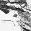
Photographic Survey (1953 - 1954)
Photographic survey of Crichton Castle in 1953-54, likely by the Ministry of Works.
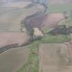
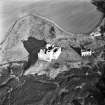
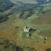
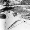
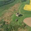
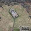
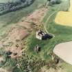
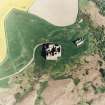
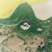
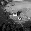
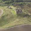
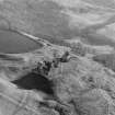
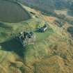
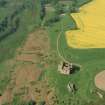
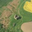
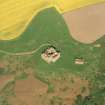
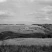
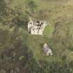
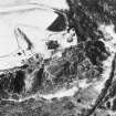
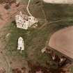
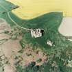
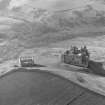
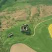
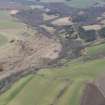
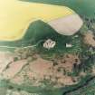
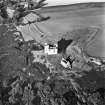
Aerial Photography (1981)
Aerial survey of Crichton Castle by RCAHMS in 1981.
Aerial Photography (1985)
Aerial survey of Crichton Castle by RCAHMS in 1985.
Aerial Photography (1994)
Aerial survey of Crichton Castle by RCAHMS in 1994
Aerial Photography (28 May 1997)
Aerial survey of Crichton Castle by RCAHMS in 1997.
Field Visit (21 October 2018)
Several instances of graffiti in the form of sets of initials, now very eroded, have been incised into the sandstone surround of the doorway in the south end of the building.
Visited by HES Survey and Recording (JRS) 21 October 2018.

