
Melville Nurseries


Pit Alignment (Prehistoric)
Site Name Melville Nurseries
Classification Pit Alignment (Prehistoric)
Canmore ID 53512
Site Number NT36NW 77
NGR NT 30912 67473
NGR Description From NT 30804 67518 to NT 31040 67421
Datum OSGB36 - NGR
Permalink http://canmore.org.uk/site/53512
Ordnance Survey licence number AC0000807262. All rights reserved.
Canmore Disclaimer.
© Bluesky International Limited 2025. Public Sector Viewing Terms
- Correction
- Favourite

DP 052459
Oblique aerial view centred on the cropmarks of the palisaded settlement and pit alignments at Melville Nurseries, taken from the WSW.
RCAHMS Aerial Photography Digital
24/7/2008
© Crown Copyright: HES


SC 1735491
Melville Nurseries, palisaded homestead and pit-alignment: oblique air photograph.
RCAHMS Aerial Photography
1990
© Crown Copyright: HES


SC 1735562
Oblique aerial view centred on the cropmarks of the palisaded homestead and pit-alignments, taken from the WSW.
RCAHMS Aerial Photography
29/6/2000
© Crown Copyright: HES

SC 2445565
Melville Nurseries, NT36NW 77, Ordnance Survey index card, page number 1, Recto
Records of the Ordnance Survey, Southampton, Hampshire, England
c. 1958
© Crown Copyright: HES (Ordnance Survey Archaeology Division)

SC 563317
Melville Nurseries, palisaded homestead and pit-alignments 1-3: oblique air photograph.
RCAHMS Aerial Photography
1984
© Crown Copyright: HES

DP 052456
Oblique aerial view centred on the cropmarks of the palisaded settlement and pit alignments at Melville Nurseries, taken from the NE.
RCAHMS Aerial Photography Digital
24/7/2008
© Crown Copyright: HES

DP 052457
Oblique aerial view centred on the cropmarks of the palisaded settlement and pit alignments at Melville Nurseries, taken from the NNW.
RCAHMS Aerial Photography Digital
24/7/2008
© Crown Copyright: HES

SC 1735485
Melville Nurseries, palisaded homestead and pit-alignments 1-2: oblique air photograph.
RCAHMS Aerial Photography
1988
© Crown Copyright: HES

SC 1735523
Melville Nurseries, palisaded homestead and pit-alignments: oblique air photograph.
RCAHMS Aerial Photography
1992
© Crown Copyright: HES

SC 1735553
Oblique aerial view centred on the cropmarks of the pit-alignments, taken from the SSE.
RCAHMS Aerial Photography
14/6/2000
© Crown Copyright: HES

SC 1735556
Oblique aerial view centred on the cropmarks of the palisaded homestead with pit-alignments adjacent, taken from the N.
RCAHMS Aerial Photography
14/6/2000
© Crown Copyright: HES

SC 1735557
Oblique aerial view centred on the cropmarks of the palisaded homestead with pit-alignments adjacent, taken from the NNW.
RCAHMS Aerial Photography
14/6/2000
© Crown Copyright: HES


SC 1735580
Melville Nurseries, palisaded homestead and pit-enclosures 1-3: oblique air photograph.
RCAHMS Aerial Photography
1981
© Crown Copyright: HES

SC 1735581
Melville Nurseries, palisaded homestead and pit-enclosures 1-3: oblique air photograph.
RCAHMS Aerial Photography
1981
© Crown Copyright: HES

SC 1735601
Melville Nurseries, pit-alignments: oblique air photograph.
RCAHMS Aerial Photography
1983
© Crown Copyright: HES

SC 1735483
Melville Nurseries, palisaded homestead and pit-alignments 1-2: oblique air photograph.
RCAHMS Aerial Photography
1988
© Crown Copyright: HES

SC 1735492
Melville Nurseries, palisaded homestead and pit-alignment: oblique air photograph.
RCAHMS Aerial Photography
1990
© Crown Copyright: HES

SC 1735494
Melville Nurseries, palisaded homestead and pit-alignment: oblique air photograph.
RCAHMS Aerial Photography
1990
© Crown Copyright: HES


SC 1735524
Melville Nurseries, palisaded homestead and pit-alignments: oblique air photograph.
RCAHMS Aerial Photography
1992
© Crown Copyright: HES

SC 1735565
Melville Nurseries, palisaded homestead and pit-alignments 1-2: oblique air photograph.
RCAHMS Aerial Photography
1978
© Crown Copyright: HES

SC 1735566
Melville Nurseries, palisaded homestead and pit-alignments 1-2: oblique air photograph.
RCAHMS Aerial Photography
1980
© Crown Copyright: HES

SC 1735603
Melville Nurseries, pit-alignments: oblique air photograph.
RCAHMS Aerial Photography
1983
© Crown Copyright: HES

SC 1735604
Melville Nurseries, pit-alignments: oblique air photograph.
RCAHMS Aerial Photography
1983
© Crown Copyright: HES

SC 1735526
Melville Nurseries, palisaded homestead and pit-alignments: oblique air photograph.
RCAHMS Aerial Photography
1992
© Crown Copyright: HES

SC 1735527
Melville Nurseries, palisaded homestead and pit-alignments: oblique air photograph.
RCAHMS Aerial Photography
1992
© Crown Copyright: HES

SC 1735531
Melville Nurseries, oblique aerial view, taken from the SE, centred on the cropmarks of a palisaded settlement and pit-alignments.
RCAHMS Aerial Photography
27/6/1996
© Crown Copyright: HES

SC 1735551
Oblique aerial view centred on the cropmarks of the pit-alignments with palisaded homestead adjacent, taken from the SSW.
RCAHMS Aerial Photography
14/6/2000
© Crown Copyright: HES

SC 1735555
Oblique aerial view centred on the cropmarks of the palisaded homestead with pit-alignments adjacent, taken from the NNE.
RCAHMS Aerial Photography
14/6/2000
© Crown Copyright: HES

SC 1735582
Melville Nurseries, palisaded homestead and pit-enclosures 1-3: oblique air photograph.
RCAHMS Aerial Photography
1981
© Crown Copyright: HES

SC 1735605
Melville Nurseries, pit-alignments: oblique air photograph.
RCAHMS Aerial Photography
1983
© Crown Copyright: HES

SC 2445563
Melville Nurseries, NT36NW 77, Ordnance Survey index card, page number 2, Recto
Records of the Ordnance Survey, Southampton, Hampshire, England
c. 1958
© Crown Copyright: HES (Ordnance Survey Archaeology Division)

SC 1735471
Melville Nurseries, palisaded homestead and pit-alignments 1-3: oblique air photograph.
RCAHMS Aerial Photography
1984
© Crown Copyright: HES

SC 1735495
Melville Nurseries, palisaded homestead and pit-alignment: oblique air photograph.
RCAHMS Aerial Photography
1990
© Crown Copyright: HES


SC 1735529
Melville Nurseries, oblique aerial view, taken from the N, centred on the cropmarks of a palisaded settlement and pit-alignments.
RCAHMS Aerial Photography
27/6/1996
© Crown Copyright: HES

SC 1735554
Oblique aerial view centred on the cropmarks of the pit-alignments with palisaded homestead adjacent, taken from the SSE.
RCAHMS Aerial Photography
14/6/2000
© Crown Copyright: HES

SC 1735560
Oblique aerial view centred on the cropmarks of the palisaded homestead and pit-alignments, taken from the NW.
RCAHMS Aerial Photography
29/6/2000
© Crown Copyright: HES

SC 1735583
Melville Nurseries, palisaded homestead and pit-enclosures 1-3: oblique air photograph.
RCAHMS Aerial Photography
1981
© Crown Copyright: HES

DP 052458
Oblique aerial view centred on the cropmarks of the palisaded settlement and pit alignments at Melville Nurseries, taken from the W.
RCAHMS Aerial Photography Digital
24/7/2008
© Crown Copyright: HES

SC 1735470
Melville Nurseries, palisaded homestead and pit-alignments 1-3: oblique air photograph.
RCAHMS Aerial Photography
1984
© Crown Copyright: HES

SC 1735472
Melville Nurseries, palisaded homestead and pit-alignments 1-3: oblique air photograph.
RCAHMS Aerial Photography
1984
© Crown Copyright: HES

SC 1735530
Melville Nurseries, oblique aerial view, taken from the WSW, centred on the cropmarks of a palisaded settlement and pit-alignments.
RCAHMS Aerial Photography
27/6/1996
© Crown Copyright: HES

SC 1735552
Oblique aerial view centred on the cropmarks of the pit-alignments with palisaded homestead adjacent, taken from the S.
RCAHMS Aerial Photography
14/6/2000
© Crown Copyright: HES

SC 1735574
Melville Nurseries, palisaded homestead and pit-alignments 1-2: oblique air photograph.
RCAHMS Aerial Photography
1980
© Crown Copyright: HES

SC 1735584
Melville Nurseries, palisaded homestead and pit-enclosures 1-3: oblique air photograph.
RCAHMS Aerial Photography
1981
© Crown Copyright: HES

SC 1735607
Melville Nurseries, pit-alignments: oblique air photograph.
RCAHMS Aerial Photography
1983
© Crown Copyright: HES

SC 2445564
Melville Nurseries, NT36NW 77, Ordnance Survey index card, Recto
Records of the Ordnance Survey, Southampton, Hampshire, England
c. 1958
© Crown Copyright: HES (Ordnance Survey Archaeology Division)

SC 1735473
Melville Nurseries, palisaded homestead and pit-alignments 1-3: oblique air photograph.
RCAHMS Aerial Photography
1984
© Crown Copyright: HES

SC 1735486
Melville Nurseries, palisaded homestead and pit-alignments 1-2: oblique air photograph.
RCAHMS Aerial Photography
1988
© Crown Copyright: HES

SC 1735550
Oblique aerial view centred on the cropmarks of the pit-alignments with palisaded homestead adjacent, taken from the SW.
RCAHMS Aerial Photography
14/6/2000
© Crown Copyright: HES

SC 1735561
Oblique aerial view centred on the cropmarks of the palisaded homestead and pit-alignments, taken from the W.
RCAHMS Aerial Photography
29/6/2000
© Crown Copyright: HES


SC 1735567
Melville Nurseries, palisaded homestead and pit-alignments 1-2: oblique air photograph.
RCAHMS Aerial Photography
1980
© Crown Copyright: HES

SC 1735602
Melville Nurseries, pit-alignments: oblique air photograph.
RCAHMS Aerial Photography
1983
© Crown Copyright: HES

SC 2445562
Melville Nurseries, NT36NW 77, Ordnance Survey index card, Recto
Records of the Ordnance Survey, Southampton, Hampshire, England
c. 1958
© Crown Copyright: HES (Ordnance Survey Archaeology Division)

SC 624575
Melville Nurseries, oblique aerial view, taken from the N, centred on the cropmarks of a palisaded settlement and pit-alignments.
RCAHMS Aerial Photography
27/6/1996
© Crown Copyright: HES

DP 052454
Oblique aerial view centred on the cropmarks of the palisaded settlement and pit alignments at Melville Nurseries, taken from the SW.
RCAHMS Aerial Photography Digital
24/7/2008
© Crown Copyright: HES

SC 1735474
Melville Nurseries, palisaded homestead and pit-alignments 1-3: oblique air photograph.
RCAHMS Aerial Photography
1984
© Crown Copyright: HES

SC 1735482
Melville Nurseries, palisaded homestead and pit-alignments 1-2: oblique air photograph.
RCAHMS Aerial Photography
1988
© Crown Copyright: HES

SC 1735484
Melville Nurseries, palisaded homestead and pit-alignments 1-2: oblique air photograph.
RCAHMS Aerial Photography
1988
© Crown Copyright: HES

SC 1735493
Melville Nurseries, palisaded homestead and pit-alignment: oblique air photograph.
RCAHMS Aerial Photography
1990
© Crown Copyright: HES


SC 1735569
Melville Nurseries, palisaded homestead and pit-alignments 1-2: oblique air photograph.
RCAHMS Aerial Photography
1980
© Crown Copyright: HES

SC 1735573
Melville Nurseries, palisaded homestead and pit-alignments 1-2: oblique air photograph.
RCAHMS Aerial Photography
1980
© Crown Copyright: HES

SC 1735585
Melville Nurseries, palisaded homestead and pit-enclosures 1-3: oblique air photograph.
RCAHMS Aerial Photography
1981
© Crown Copyright: HES

SC 1735600
Melville Nurseries, pit-alignments: oblique air photograph.
RCAHMS Aerial Photography
1983
© Crown Copyright: HES

SC 1735606
Melville Nurseries, pit-alignments: oblique air photograph.
RCAHMS Aerial Photography
1983
© Crown Copyright: HES


- Council Midlothian
- Parish Lasswade
- Former Region Lothian
- Former District Midlothian
- Former County Midlothian
Note (1988)
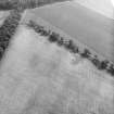
Melville Nurseries NT 31 67 & 30 67 NT36NW 76 77 & 82
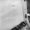
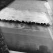
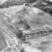
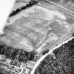
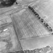
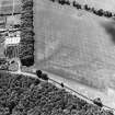
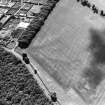
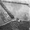
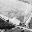
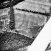
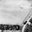
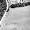
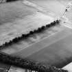
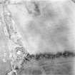
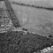
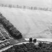
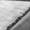
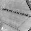
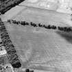
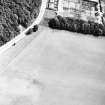
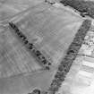
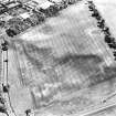
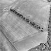
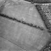
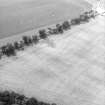
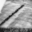
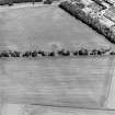
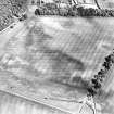
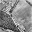
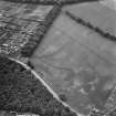
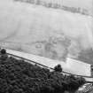
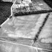
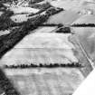
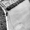
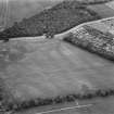
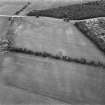
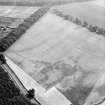
Cropmarks reveal two lines of pits in the fields to the W of Melville Nurseries. The first runs SSW from a point 50m SE of the palisaded homestead NT36NW 10 (NT 3102 6756) for a distance of about 220m, before turning WSW for a further 150m (NT 3074 6730). The second extends towards the E from the W boundary of Melville Nurseries (NT 3106 6742), turning to cross the first at right angles about 130m S of the home stead, and then continuing towards the WNW (NT 3078 6753).
RCAHMS 1988

