
Following the launch of trove.scot in February 2025 we are now planning the retiral of some of our webservices. Canmore will be switched off on 24th June 2025. Information about the closure can be found on the HES website: Retiral of HES web services | Historic Environment Scotland
Smeaton House


Tower House (Medieval), Wall(S) (Medieval)
Site Name Smeaton House
Classification Tower House (Medieval), Wall(S) (Medieval)
Alternative Name(s) Dalkeith Home Farm; Smeaton Home Farm; Smeaton Castle
Canmore ID 53473
Site Number NT36NW 44
NGR NT 34787 69689
Datum OSGB36 - NGR
Permalink http://canmore.org.uk/site/53473


- Council East Lothian
- Parish Inveresk (East Lothian)
- Former Region Lothian
- Former District East Lothian
- Former County Midlothian
NT36NW 44 3479 6969.
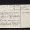
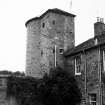
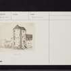
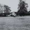
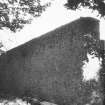
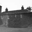
(NT 3479 6969) Smeaton Castle, once a large courtyard style castle, is now named Dalkeith Home Farm. It appears to have been an impressive establishment of possibly the 15th c, with later alterations, enclosing an oblong courtyard, with circular flanking-towers at the angles, of which only those at the NW and SW remain, with a main range of lower level along the S curtain wall, now modernised. No traces of the E towers or perimeter walling on that side are now evident. Indications of the moat remain.
The main feature is the SW tower, circular, but with a square-tower attached to the E. Entire to the eaves-course, it has a modern roof. It is now four storeys high but the floor levels have been altered; some of the windows have been enlarged. The slightly smaller NW tower has been reduced in height. The section of curtain walling connecting the towers bears a series of fairly large windows, old but not original. Presumably a lean-to building was erected here, possibly a large hall. The range along the S front, always the main dwelling-house, now retains no original features externally, except for the basement course and two small windows.
An early reference shows that the lands of Smeaton belonged to Dunfermline Abbey in 1450. In 1563, a charter was confirmed to Robert Richardson, Treasurer of Scotland. Another charter of 1576 mentions the fortalice, though the surviving buildings indicate a date earlier than this. It may be noted that in 1547, after the Battle of Pinkie, the English commander methodically destroyed all the substantial buildings in the area. It is hardly likely that Smeaton escaped. Possibly it was this derelict property that the Treasurer restored.
N Tranter 1970
Smeaton Castle, in use as a farmhouse, is as described.
Visited by OS (BS) 31 October 1975
NMRS REFERENCE:
ARCHITECT:
James Smith 1710 - 1711 (Attribution)
John Adam visited to inspect for necessary repairs June 1752.
EXTERNAL REFERENCE:
Scottish Record Office
RHP 9520 1718 - plan of lands
RHP 9521 1799 - plan of lands
Photographic Survey (May 1961)
Photographic survey by the Scottish National Buildings Record in 1961.
Photographic Survey (1967)
Photographic survey by the Scottish National Buildings Record in 1967.
Field Visit (31 October 1975)
Smeaton Castle, in use as a farmhouse, is as described.
Visited by OS (BS) 31 October 1975

