
Melville Nurseries


Palisaded Settlement (Iron Age)
Site Name Melville Nurseries
Classification Palisaded Settlement (Iron Age)
Canmore ID 53406
Site Number NT36NW 10
NGR NT 31002 67617
Datum OSGB36 - NGR
Permalink http://canmore.org.uk/site/53406
Ordnance Survey licence number AC0000807262. All rights reserved.
Canmore Disclaimer.
© Bluesky International Limited 2025. Public Sector Viewing Terms
- Correction
- Favourite

DP 052459
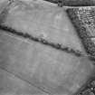
Oblique aerial view centred on the cropmarks of the palisaded settlement and pit alignments at Melville Nurseries, taken from the WSW.
RCAHMS Aerial Photography Digital
24/7/2008
© Crown Copyright: HES


SC 1735491
Melville Nurseries, palisaded homestead and pit-alignment: oblique air photograph.
RCAHMS Aerial Photography
1990
© Crown Copyright: HES

SC 1735500
Melville Nurseries, palisaded homestead: oblique air photograph.
RCAHMS Aerial Photography
1991
© Crown Copyright: HES

SC 1735518
Melville Nurseries, palisaded homestead and pit-alignments: oblique air photograph.
RCAHMS Aerial Photography
23/6/1994
© Crown Copyright: HES

SC 1735559
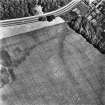
Oblique aerial view centred on the cropmarks of the palisaded homestead, taken from the SW.
RCAHMS Aerial Photography
14/6/2000
© Crown Copyright: HES

SC 1735562
Oblique aerial view centred on the cropmarks of the palisaded homestead and pit-alignments, taken from the WSW.
RCAHMS Aerial Photography
29/6/2000
© Crown Copyright: HES

SC 1735570
Melville Nurseries, palisaded homestead and pit-alignment 1: oblique air photograph.
RCAHMS Aerial Photography
1980
© Crown Copyright: HES

SC 563317
Melville Nurseries, palisaded homestead and pit-alignments 1-3: oblique air photograph.
RCAHMS Aerial Photography
1984
© Crown Copyright: HES

DP 052456
Oblique aerial view centred on the cropmarks of the palisaded settlement and pit alignments at Melville Nurseries, taken from the NE.
RCAHMS Aerial Photography Digital
24/7/2008
© Crown Copyright: HES

DP 052457
Oblique aerial view centred on the cropmarks of the palisaded settlement and pit alignments at Melville Nurseries, taken from the NNW.
RCAHMS Aerial Photography Digital
24/7/2008
© Crown Copyright: HES


SC 1735485
Melville Nurseries, palisaded homestead and pit-alignments 1-2: oblique air photograph.
RCAHMS Aerial Photography
1988
© Crown Copyright: HES


SC 1735503
Melville Nurseries, palisaded homestead: oblique air photograph.
RCAHMS Aerial Photography
1991
© Crown Copyright: HES

SC 1735523
Melville Nurseries, palisaded homestead and pit-alignments: oblique air photograph.
RCAHMS Aerial Photography
1992
© Crown Copyright: HES

SC 1735549
Oblique aerial view centred on the cropmarks of the palisaded homestead and pit-alignment, taken from the SW.
RCAHMS Aerial Photography
9/6/2000
© Crown Copyright: HES

SC 1735556
Oblique aerial view centred on the cropmarks of the palisaded homestead with pit-alignments adjacent, taken from the N.
RCAHMS Aerial Photography
14/6/2000
© Crown Copyright: HES

SC 1735557
Oblique aerial view centred on the cropmarks of the palisaded homestead with pit-alignments adjacent, taken from the NNW.
RCAHMS Aerial Photography
14/6/2000
© Crown Copyright: HES


SC 1735580
Melville Nurseries, palisaded homestead and pit-enclosures 1-3: oblique air photograph.
RCAHMS Aerial Photography
1981
© Crown Copyright: HES

SC 1735581
Melville Nurseries, palisaded homestead and pit-enclosures 1-3: oblique air photograph.
RCAHMS Aerial Photography
1981
© Crown Copyright: HES

DP 281238
Oblique aerial view.
Historic Environment Scotland
21/6/2018
© Copyright: HES

SC 2445379
Melville Nurseries, NT36NW 10, Ordnance Survey index card, page number 1, Recto
Records of the Ordnance Survey, Southampton, Hampshire, England
c. 1958
© Crown Copyright: HES (Ordnance Survey Archaeology Division)

SC 2445380
Melville Nurseries, NT36NW 10, Ordnance Survey index card, page number 2, Recto
Records of the Ordnance Survey, Southampton, Hampshire, England
c. 1958
© Crown Copyright: HES (Ordnance Survey Archaeology Division)

SC 1735483
Melville Nurseries, palisaded homestead and pit-alignments 1-2: oblique air photograph.
RCAHMS Aerial Photography
1988
© Crown Copyright: HES

SC 1735492
Melville Nurseries, palisaded homestead and pit-alignment: oblique air photograph.
RCAHMS Aerial Photography
1990
© Crown Copyright: HES

SC 1735494
Melville Nurseries, palisaded homestead and pit-alignment: oblique air photograph.
RCAHMS Aerial Photography
1990
© Crown Copyright: HES


SC 1735524
Melville Nurseries, palisaded homestead and pit-alignments: oblique air photograph.
RCAHMS Aerial Photography
1992
© Crown Copyright: HES

SC 1735565
Melville Nurseries, palisaded homestead and pit-alignments 1-2: oblique air photograph.
RCAHMS Aerial Photography
1978
© Crown Copyright: HES

SC 1735566
Melville Nurseries, palisaded homestead and pit-alignments 1-2: oblique air photograph.
RCAHMS Aerial Photography
1980
© Crown Copyright: HES

SC 1735576
Melville Nurseries, palisaded homestead: oblique air photograph.
RCAHMS Aerial Photography
1981
© Crown Copyright: HES

SC 1735579
Melville Nurseries, palisaded homestead: oblique air photograph.
RCAHMS Aerial Photography
1981
© Crown Copyright: HES


SC 1735526
Melville Nurseries, palisaded homestead and pit-alignments: oblique air photograph.
RCAHMS Aerial Photography
1992
© Crown Copyright: HES

SC 1735527
Melville Nurseries, palisaded homestead and pit-alignments: oblique air photograph.
RCAHMS Aerial Photography
1992
© Crown Copyright: HES

SC 1735531
Melville Nurseries, oblique aerial view, taken from the SE, centred on the cropmarks of a palisaded settlement and pit-alignments.
RCAHMS Aerial Photography
27/6/1996
© Crown Copyright: HES

SC 1735546
Oblique aerial view of Melville Nurseries centred on the cropmarks of a palisaded homestead, taken from the NW.
RCAHMS Aerial Photography
24/7/1998
© Crown Copyright: HES

SC 1735547
Oblique aerial view of Melville Nurseries centred on the cropmarks of a palisaded homestead, taken from the SW.
RCAHMS Aerial Photography
24/7/1998
© Crown Copyright: HES

SC 1735551
Oblique aerial view centred on the cropmarks of the pit-alignments with palisaded homestead adjacent, taken from the SSW.
RCAHMS Aerial Photography
14/6/2000
© Crown Copyright: HES

SC 1735555
Oblique aerial view centred on the cropmarks of the palisaded homestead with pit-alignments adjacent, taken from the NNE.
RCAHMS Aerial Photography
14/6/2000
© Crown Copyright: HES

SC 1735578
Melville Nurseries, palisaded homestead: oblique air photograph.
RCAHMS Aerial Photography
1981
© Crown Copyright: HES

SC 1735582
Melville Nurseries, palisaded homestead and pit-enclosures 1-3: oblique air photograph.
RCAHMS Aerial Photography
1981
© Crown Copyright: HES

SC 2445375
Melville Nurseries, NT36NW 10, Ordnance Survey index card, Recto
Records of the Ordnance Survey, Southampton, Hampshire, England
c. 1958
© Crown Copyright: HES (Ordnance Survey Archaeology Division)

DP 052455
Oblique aerial view centred on the cropmarks of the palisaded settlement and pit alignments at Melville Nurseries, taken from the SSW.
RCAHMS Aerial Photography Digital
24/7/2008
© Crown Copyright: HES

SC 1735471
Melville Nurseries, palisaded homestead and pit-alignments 1-3: oblique air photograph.
RCAHMS Aerial Photography
1984
© Crown Copyright: HES

SC 1735495
Melville Nurseries, palisaded homestead and pit-alignment: oblique air photograph.
RCAHMS Aerial Photography
1990
© Crown Copyright: HES

SC 1735529
Melville Nurseries, oblique aerial view, taken from the N, centred on the cropmarks of a palisaded settlement and pit-alignments.
RCAHMS Aerial Photography
27/6/1996
© Crown Copyright: HES

SC 1735554
Oblique aerial view centred on the cropmarks of the pit-alignments with palisaded homestead adjacent, taken from the SSE.
RCAHMS Aerial Photography
14/6/2000
© Crown Copyright: HES

SC 1735560
Oblique aerial view centred on the cropmarks of the palisaded homestead and pit-alignments, taken from the NW.
RCAHMS Aerial Photography
29/6/2000
© Crown Copyright: HES

SC 1735583
Melville Nurseries, palisaded homestead and pit-enclosures 1-3: oblique air photograph.
RCAHMS Aerial Photography
1981
© Crown Copyright: HES

SC 2445373
Melville Nurseries, NT36NW 10, Ordnance Survey index card, Recto
Records of the Ordnance Survey, Southampton, Hampshire, England
c. 1958
© Crown Copyright: HES (Ordnance Survey Archaeology Division)

DP 052458
Oblique aerial view centred on the cropmarks of the palisaded settlement and pit alignments at Melville Nurseries, taken from the W.
RCAHMS Aerial Photography Digital
24/7/2008
© Crown Copyright: HES


SC 1735470
Melville Nurseries, palisaded homestead and pit-alignments 1-3: oblique air photograph.
RCAHMS Aerial Photography
1984
© Crown Copyright: HES

SC 1735472
Melville Nurseries, palisaded homestead and pit-alignments 1-3: oblique air photograph.
RCAHMS Aerial Photography
1984
© Crown Copyright: HES

SC 1735475
Melville Nurseries, palisaded homestead and pit-alignments 1-2: oblique air photograph.
RCAHMS Aerial Photography
1984
© Crown Copyright: HES

SC 1735530
Melville Nurseries, oblique aerial view, taken from the WSW, centred on the cropmarks of a palisaded settlement and pit-alignments.
RCAHMS Aerial Photography
27/6/1996
© Crown Copyright: HES

SC 1735552
Oblique aerial view centred on the cropmarks of the pit-alignments with palisaded homestead adjacent, taken from the S.
RCAHMS Aerial Photography
14/6/2000
© Crown Copyright: HES

SC 1735574
Melville Nurseries, palisaded homestead and pit-alignments 1-2: oblique air photograph.
RCAHMS Aerial Photography
1980
© Crown Copyright: HES

SC 1735577
Melville Nurseries, palisaded homestead: oblique air photograph.
RCAHMS Aerial Photography
1981
© Crown Copyright: HES

SC 1735584
Melville Nurseries, palisaded homestead and pit-enclosures 1-3: oblique air photograph.
RCAHMS Aerial Photography
1981
© Crown Copyright: HES

SC 2445376
Melville Nurseries, NT36NW 10, Ordnance Survey index card, Recto
Records of the Ordnance Survey, Southampton, Hampshire, England
c. 1958
© Crown Copyright: HES (Ordnance Survey Archaeology Division)

SC 2445377
Melville Nurseries, NT36NW 10, Ordnance Survey index card, Recto
Records of the Ordnance Survey, Southampton, Hampshire, England
c. 1958
© Crown Copyright: HES (Ordnance Survey Archaeology Division)

SC 2445378
Melville Nurseries, NT36NW 10, Ordnance Survey index card, Recto
Records of the Ordnance Survey, Southampton, Hampshire, England
c. 1958
© Crown Copyright: HES (Ordnance Survey Archaeology Division)

SC 1735473
Melville Nurseries, palisaded homestead and pit-alignments 1-3: oblique air photograph.
RCAHMS Aerial Photography
1984
© Crown Copyright: HES

SC 1735502
Melville Nurseries, palisaded homestead: oblique air photograph.
RCAHMS Aerial Photography
1991
© Crown Copyright: HES

SC 1735550
Oblique aerial view centred on the cropmarks of the pit-alignments with palisaded homestead adjacent, taken from the SW.
RCAHMS Aerial Photography
14/6/2000
© Crown Copyright: HES

SC 1735558
Oblique aerial view centred on the cropmarks of the palisaded homestead, taken from the W.
RCAHMS Aerial Photography
14/6/2000
© Crown Copyright: HES

SC 1735561
Oblique aerial view centred on the cropmarks of the palisaded homestead and pit-alignments, taken from the W.
RCAHMS Aerial Photography
29/6/2000
© Crown Copyright: HES


SC 1735567
Melville Nurseries, palisaded homestead and pit-alignments 1-2: oblique air photograph.
RCAHMS Aerial Photography
1980
© Crown Copyright: HES

SC 624575
Melville Nurseries, oblique aerial view, taken from the N, centred on the cropmarks of a palisaded settlement and pit-alignments.
RCAHMS Aerial Photography
27/6/1996
© Crown Copyright: HES

DP 052454
Oblique aerial view centred on the cropmarks of the palisaded settlement and pit alignments at Melville Nurseries, taken from the SW.
RCAHMS Aerial Photography Digital
24/7/2008
© Crown Copyright: HES


SC 1735467
Melville Nurseries, palisaded homestead: oblique air phptograph.
RCAHMS Aerial Photography
1986
© Crown Copyright: HES

SC 1735474
Melville Nurseries, palisaded homestead and pit-alignments 1-3: oblique air photograph.
RCAHMS Aerial Photography
1984
© Crown Copyright: HES

SC 1735482
Melville Nurseries, palisaded homestead and pit-alignments 1-2: oblique air photograph.
RCAHMS Aerial Photography
1988
© Crown Copyright: HES

SC 1735493
Melville Nurseries, palisaded homestead and pit-alignment: oblique air photograph.
RCAHMS Aerial Photography
1990
© Crown Copyright: HES

SC 1735501
Melville Nurseries, palisaded homestead: oblique air photograph.
RCAHMS Aerial Photography
1991
© Crown Copyright: HES

SC 1735517
Melville Nurseries, palisaded homestead and pit-alignments: oblique air photograph.
RCAHMS Aerial Photography
23/6/1994
© Crown Copyright: HES


SC 1735545
Oblique aerial view of Melville Nurseries centred on the cropmarks of a palisaded homestead, taken from the NNE.
RCAHMS Aerial Photography
24/7/1998
© Crown Copyright: HES

SC 1735548
Oblique aerial view centred on the cropmarks of the palisaded homestead and pit-alignment, taken from the N.
RCAHMS Aerial Photography
9/6/2000
© Crown Copyright: HES

SC 1735568
Melville Nurseries, palisaded homestead and pit-alignment 1: oblique air photograph.
RCAHMS Aerial Photography
1980
© Crown Copyright: HES

SC 1735569
Melville Nurseries, palisaded homestead and pit-alignments 1-2: oblique air photograph.
RCAHMS Aerial Photography
1980
© Crown Copyright: HES

SC 1735573
Melville Nurseries, palisaded homestead and pit-alignments 1-2: oblique air photograph.
RCAHMS Aerial Photography
1980
© Crown Copyright: HES

SC 1735585
Melville Nurseries, palisaded homestead and pit-enclosures 1-3: oblique air photograph.
RCAHMS Aerial Photography
1981
© Crown Copyright: HES

SC 2445374
Melville Nurseries, NT36NW 10, Ordnance Survey index card, Recto
Records of the Ordnance Survey, Southampton, Hampshire, England
c. 1958
© Crown Copyright: HES (Ordnance Survey Archaeology Division)


- Council Midlothian
- Parish Lasswade
- Former Region Lothian
- Former District Midlothian
- Former County Midlothian
Note (1988)
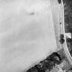
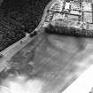
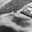
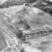
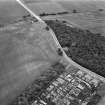
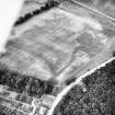
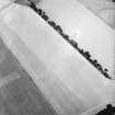
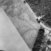
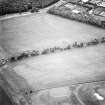
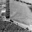
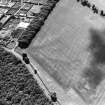
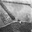
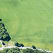
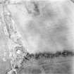
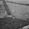
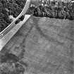
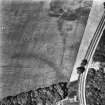
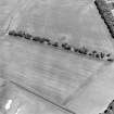
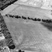
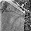
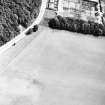
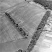
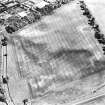
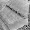
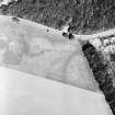
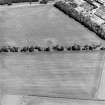
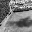
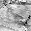
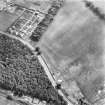
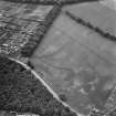
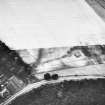
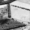
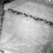
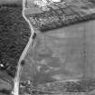
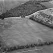
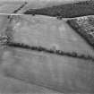
Melville Nurseries NT 3096 6760 NT36NW 10
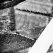
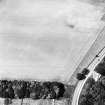
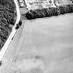
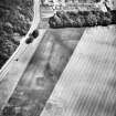
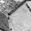
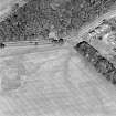
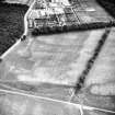
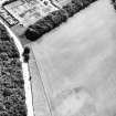
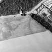
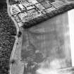
A roughly circular palisaded homestead is revealed by cropmarks to the W of Melville Nurseries, some 40m S of the public road (A7). It measures 40m in diameter within a pair of palisade trenches set 5m apart, and what were probably two superimposed timber houses, each about 15m in diameter, are visible at the centre of the interior. About 5m beyond the outer palisade there are traces of what may be a third palisade trench.
RCAHMS 1988

