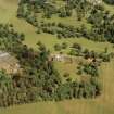
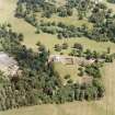
Accessibility

Font Size

100% 150% 200%

Background Colour

Default Contrast
Close Reset

Preston Hall

Country House (18th Century)

Site Name Preston Hall

Classification Country House (18th Century)

Alternative Name(s) Prestonhall; Preston Hall Policies

Canmore ID 53386

Site Number NT36NE 61

NGR NT 39431 65760

Datum OSGB36 - NGR

Permalink http://canmore.org.uk/site/53386

Ordnance Survey licence number AC0000807262. All rights reserved.
Canmore Disclaimer. © Bluesky International Limited 2025. Public Sector Viewing Terms

Toggle Aerial | View on large map

Digital Images

Oblique aerial view, taken from the SW, centred on Oxenfoord Castle.  Preston Hall is also visible in the top right hand corner of the photograph.
Oblique aerial view, taken from the SW, centred on Oxenfoord Castle.  Preston Hall is also visible in the top right hand corner of the photograph.General oblique aerial view of Preston Hall with adjacent stables, looking to the E.General oblique aerial view of Preston Hall with adjacent stables, looking to the NE.General oblique aerial view of Oxenfoord Castle and Preston House with Tyne Bridge in the foreground, looking to the N.Aerial view.Preston Hall, oblique aerial view, taken from the S, centred on the country house.Preston Hall, oblique aerial view, taken from the S, centred on the country house with the formal garden in the centre left of the photograph.General oblique aerial view of Preston Hall with adjacent walled garden, looking to the NNW.Oblique aerial view of Preston Hall, looking to the WNW.Preston Hall, oblique aerial view, taken from the SSE, centred on the country house.Oblique aerial view, taken from the SW, centred on the country house with the formal garden in the top left-hand corner of the photograph.Oblique aerial view of Preston Hall, looking to the N.General oblique aerial view of Oxenfoord Castle and Preston House, looking to the NE.Oblique aerial view, taken from the SW, centred on the country house with the formal garden in the top left-hand corner of the photograph.Aerial view.Preston Hall, oblique aerial view, taken from the SE, centred on the country house.Preston Hall, oblique aerial view, taken from the SSW, centred on the country house.Preston Hall, oblique aerial view, taken from the SSE, centred on the country house.Preston Hall, oblique aerial view, taken from the SW, centred on the country house with the stables in the top left-hand corner of the photograph.Preston Hall, oblique aerial view, taken from the S, centred on the country house with the stables in the top right-hand corner of the photograph.Preston Hall, NT36NE 61, Ordnance Survey index card, RectoGeneral oblique aerial view of Preston Hall with adjacent walled garden, looking to the SSE.Aerial view.Aerial view.Aerial view.Preston Hall, oblique aerial view, taken from the S, centred on the country house with the stables and formal gardens on either side.Preston Hall, oblique aerial view, taken from the N, centred on the country house.Preston Hall, oblique aerial view, taken from the SSE, centred on the country house with the stables in the top right-hand corner of the photograph.Aerial view.Aerial view.Aerial view.Aerial view.Preston Hall, oblique aerial view, taken from the SE, centred on the country house with the formal garden in the centre left of the photograph.Preston Hall, oblique aerial view, taken from the ESE, centred on the country house with the stables and formal gardens on either side.Aerial view.Preston Hall, oblique aerial view, taken from the SW, centred on the country house with the stables in the top centre of the photograph.Preston Hall, NT36NE 61, Ordnance Survey index card, RectoView of landing.Oblique aerial view, taken from the SW, centred on Oxenfoord Castle.  Preston Hall is also visible in the top right hand corner of the photograph.Preston Hall, oblique aerial view, taken from the NNW, centred on the country house.Preston Hall, NT36NE 61, Ordnance Survey index card, RectoPreston Hall, NT36NE 61, Ordnance Survey index card, RectoView from SW.Interior.
Detail of fireplace.

Administrative Areas

  • Council Midlothian
  • Parish Cranston
  • Former Region Lothian
  • Former District Midlothian
  • Former County Midlothian

Architecture Notes

NT36NE 61.00 39431 65760

NT36NE 61.01 39503 66419 The Temple

NT36NE 61.02 39628 65930 Stables, Northern Block

NT36NE 61.03 39242 65952 Walled garden

NT36NE 61.04 39252 65209 Lion's Gate

NT36NE 61.05 39248 65997 Gardener's Cottage

NT36NE 61.06 39249 65981 E Gazebo

NT36NE 61.07 39237 65980 W Gazebo

NT36NE 61.08 39243 65930 Sundial

NT36NE 61.09 39611 65903 Stables, Southern Block and Pheasantry

NT36NE 61.10 39658 65896 Stables, Outbuilding and Piggery

NT36NE 61.11 39643 65902 Stables, Piggery Lean-to

NT36NE 61.12 39660 65913 Stables, Cottages

NT36NE 61.13 39654 65934 Stables, Kennels

NT36NE 41 39065 65875 Ice-house

NT46NW 126 40277 67156 North Gate

NT46NW 158 40055 65927 Keeper's Lodge

Begun 1791, architect Robert Mitchell.

C McWilliam 1978.

NMRS REFERENCE:

Owner: Major W. H. Callander

Architect: Robert Mitchell c.1794. also architect of the stables

David Bryce porch c.1850

See 'Edinburgh Magazine' March 1800

Print and description

EXTERNAL REFERENCE:

Edinburgh University Library, "Views & Perspectives of houses in England and Scotland" by Robert Mitchell. 1801 - plans and elevations & 3 coloured engravings.

Preston Hall - Coade stone

As well as the four figures (one marked coade 1794) in the hall (Erechtheion - type caryatid, Vestal Virgin and 2 others to be researched) and the Florentine Lions at the gate, (all in Pevsner Lothians) there are 4 ionic pilaster capitals and a coat of arms on the main front (now the back) and decorations of a mask and draperies on aediacles on single storey wings.

Information from Miss Alison Kelly, 1983

Activities

Photographic Survey (1955)

Photographs of Preston Hall, Midlothian, by the Scottish National Buildings Record in 1955

References

MyCanmore Image Contributions


Contribute an Image

MyCanmore Text Contributions