
Chalkieside


Enclosed Settlement (Prehistoric)
Site Name Chalkieside
Classification Enclosed Settlement (Prehistoric)
Canmore ID 53375
Site Number NT36NE 51
NGR NT 36249 68182
Datum OSGB36 - NGR
Permalink http://canmore.org.uk/site/53375


- Council Midlothian
- Parish Dalkeith
- Former Region Lothian
- Former District Midlothian
- Former County Midlothian
NT36NE 51 36249 68182.
Site identified during an archaeological assessment carried out by CFA Archaeology Ltd.
Mhairi Hastie, 2006.
Note (1988)
Chalkieside NT 3628 6815 NT36NE 51
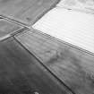
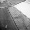
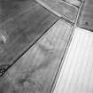
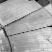
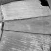
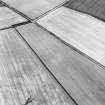
Cropmarks reveal a pear-shaped enclosure, measuring 40m by 30m within a ditch 2m broad, 600m SW of Chalkieside.
RCAHMS 1988
Aerial Photographic Transcription (13 December 1990 - 18 December 1990)
An aerial transcription was produced from oblique aerial photographs. Information from Historic Environment Scotland (BM) 31 March 2017.

