Edinburgh, Holyrood Park, St Anthony's Well
Holy Well (Period Unassigned)
Site Name Edinburgh, Holyrood Park, St Anthony's Well
Classification Holy Well (Period Unassigned)
Alternative Name(s) Queen's Park
Canmore ID 52448
Site Number NT27SE 40
NGR NT 27522 73648
Datum OSGB36 - NGR
Permalink http://canmore.org.uk/site/52448
- Council Edinburgh, City Of
- Parish Edinburgh (Edinburgh, City Of)
- Former Region Lothian
- Former District City Of Edinburgh
- Former County Midlothian
NT27SE 40 2752 7364.
(NT 2752 7364) St Anthony's Well (NR)
OS 25"map, (1968)
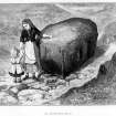
St Anthony's Well a holy well (ONB 1852) springs from below a boulder on the approach to St Anthony's Chapel. Until 1674, however, the spring flowed from under a little stone arch situated at a rather higher level. Name Book 1852; RCAHMS 1951.
This well is as described in previous information. The stone arch no longer exists.
Visited by OS (S F S) 2 December 1975.
All that can now be seen at the site of this well is a narrow lead pipe, which protrudes from beneath a large rounded boulder and channels water into a stone bowl placed immediately below.
Visited by RCAHMS (ARG), 15 December 1998
NMRS, MS/726/96 (54, no. 38); RCAHMS 1999.
Condition Survey (February 1996)
The site consists of a large rounded boulder c. 1.5m long, 1m wide and 0.9m high. Below this large boulder there is a stone bowl c. 0.5m in diameter and 0.4m high which was fed by a small lead pipe protruding from underneath the boulder. The well appears to have dried up and no trace was found of the earlier stone arch. A length of track which leads up to the boulder and around its north-eastern side may have been the access track to St Anthony’s Chapel. It is defined by a length of stone kerning c. 58m long, 0.6m wide and 0.1 - 0.2m wide. The track is crossed by two cross ridges, or steps, 27m and 44m from the west end. At the east end there are a set of 33 worn steps, each consisting of 3 - 5 flat stones, leading up and around the well. The date of this trackway and steps is unknown but it seems to be suffering from heavy use.
Information from Derek Alexander (Centre for Field Archaeology, University of Edinburgh) February 1997, no.38
Alexander 1997
Condition Survey (12 March 2018 - 15 April 2018)
The remains of this well were described by Alexander (1997). The site comprises a large rounded boulder c. 1.5m long, 1m wide and 0.9m high below which there is a stone bowl c. 0.5m in diameter and 0.4m high fed by a small lead pipe protruding from underneath the boulder. The well appears to have dried up and no trace was found of the earlier stone arch. A length of track which leads up to the boulder and around its north-eastern side may have been the access track to St Anthony’s Chapel. It is defined by a length of stone kerbing c. 58m long, 0.6m wide and 0.1 - 0.2m wide. The track is crossed by two cross ridges, or steps, 27m and 44m from the west end. At the east end there are a set of 33 worn steps, each consisting of 3 - 5 flat stones, leading up and around the well. The date of this trackway and steps is unknown but it seems to be suffering from heavy use.
The 2018 CFA Archaeology Ltd condition survey found the site as previously described. Two rectangular holes cut into the front the large boulder above the ‘font’ stone were also noted. The holes are 2.5cm by 5cm and the right one has the remains of a metal fitting. The left one appeared empty. These holes were for the attaching a chains for drinking cups to the stone. A postcard written on April 13th 1914 in the ‘Knox Series’ by William J Hay shows the well with the chains and cups (Europeana Foundation 2018).
Information from Graeme Carruthers (CFA Archaeology Ltd) July 2018. OASIS ID: cfaarcha1-317194, no.38
Alexander 1997; Europeana Foundation 2018.


