|
Prints and Drawings |
DC 40496 |
|
Electrical Services drawing : plan of proposed tunnel - general arrangements. |
1988 |
Item Level |
|
|
Prints and Drawings |
DC 40498 |
|
Electrical Services drawing : copy of drawing M607/GA1. |
1988 |
Item Level |
|
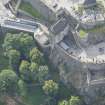 |
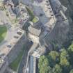
On-line Digital Images |
DP 221114 |
RCAHMS Aerial Photography Digital |
Oblique aerial view of Edinburgh Castle centred on the Portcullis Gate and Argyle Tower, looking S. |
11/9/2015 |
Item Level |
|
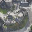 |
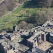
On-line Digital Images |
DP 221115 |
RCAHMS Aerial Photography Digital |
Oblique aerial view of Edinburgh Castle centred on St Margaret's Chapel, looking S. |
11/9/2015 |
Item Level |
|
 |
On-line Digital Images |
DP 221121 |
RCAHMS Aerial Photography Digital |
Oblique aerial view of Edinburgh Castle centred on St Margaret's Chapel, looking ENE. |
11/9/2015 |
Item Level |
|
 |
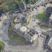
On-line Digital Images |
DP 221122 |
RCAHMS Aerial Photography Digital |
Oblique aerial view of Edinburgh Castle centred on the Portcullis Gate and Argyle Tower, looking NE. |
11/9/2015 |
Item Level |
|
 |
On-line Digital Images |
DP 221129 |
RCAHMS Aerial Photography Digital |
Oblique aerial view of Edinburgh Castle centred on the Portcullis Gate and Argyle Tower, looking NW. |
11/9/2015 |
Item Level |
|
 |
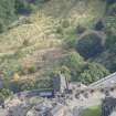
On-line Digital Images |
DP 221146 |
RCAHMS Aerial Photography Digital |
Oblique aerial view of Edinburgh Castle centred on the Scottish National War Memorial, looking NE. |
11/9/2015 |
Item Level |
|
 |
On-line Digital Images |
DP 250929 |
Historic Environment Scotland |
Oblique aerial view. |
27/3/2017 |
Item Level |
|
 |
On-line Digital Images |
SC 2442990 |
Records of the Ordnance Survey, Southampton, Hampshire, England |
Edinburgh, West Mains Road, University Of Edinburgh, King's Buildings, Civil And Environmental Engineering, NT27SE 1.6, Ordnance Survey index card, Recto |
c. 1958 |
Item Level |
|
 |
On-line Digital Images |
SC 2442991 |
Records of the Ordnance Survey, Southampton, Hampshire, England |
Edinburgh, West Mains Road, University Of Edinburgh, King's Buildings, Civil And Environmental Engineering, NT27SE 1.6, Ordnance Survey index card, Recto |
c. 1958 |
Item Level |
|
|
All Other |
551 166/1/1 |
Records of the Ordnance Survey, Southampton, Hampshire, England |
Archaeological site card index ('495' cards) |
1947 |
Sub-Group Level |
|


