
Castlelaw Hill


Ring Ditch House (Prehistoric)
Site Name Castlelaw Hill
Classification Ring Ditch House (Prehistoric)
Alternative Name(s) Castle Law; Castlelaw Range
Canmore ID 51898
Site Number NT26SW 44
NGR NT 22296 64150
Datum OSGB36 - NGR
Permalink http://canmore.org.uk/site/51898


- Council Midlothian
- Parish Glencorse
- Former Region Lothian
- Former District Midlothian
- Former County Midlothian
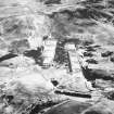
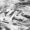
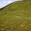
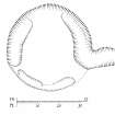
This ring-ditch house is situated on a grassy spur above and immediately W of the Castlelaw firing ranges (NT26SW 65). It measures about 12.5m in diameter over a shallow ditch up to 2m in breadth, and the entrance is probably on the E, where the ditch turns out across the line of the wall and peters out after a distance of about 4.5m.
(CDTA05 47)
Visited by RCAHMS (AGCH) 6 June 2005.
Note (1988)
Castlelaw Hill NT 2224 6410 NT26SW 44
A ring-ditch house is situated on a spur that projects from the foot of Castlelaw Hill immediately W of the rifle range. The house measures 12m in overall diameter, its ditch comprising a series of shallow scoops up to 2.5m in breadth. The entrance is probably on the SE where one of the scoops turns outwards and extends about 4.5m beyond the presumed line of the house wall.
RCAHMS 1988
(Reynolds 1982, 48)

