
Pricing Change
New pricing for orders of material from this site will come into place shortly. Charges for supply of digital images, digitisation on demand, prints and licensing will be altered.
Border - Crawford - Inveresk (?)


Roman Road (Roman)
Site Name Border - Crawford - Inveresk (?)
Classification Roman Road (Roman)
Alternative Name(s) Silverburn; Glencorse
Canmore ID 51859
Site Number NT26SW 59
NGR NT 2005 6000
NGR Description NT 2005 6000 to NT 2499 6377
Datum OSGB36 - NGR
Permalink http://canmore.org.uk/site/51859


- Council Midlothian
- Parish Penicuik (Midlothian)
- Former Region Lothian
- Former District Midlothian
- Former County Midlothian
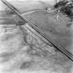
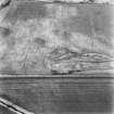
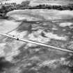
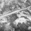
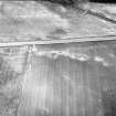
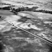
NT26SW 59 2005 6000 to 2499 6377 RR 1.
Formerly RR 7g.
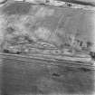
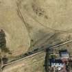
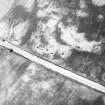
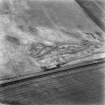
The course of the Roman road across this sheet is probably largely overlain by the modern A702. Its immediate destination is uncertain, but it may originally have led to the fort at Elginhaugh (NT36NW 61) by way of the camp at Flotterstone (NT26SW 33, at NT 232 627).
I D Margary 1957; RCAHMS 1988.
NT 2005 6000 - NT 2242 6175 Modern road on probable course of Roman road.
NT 2242 6175 - NT 2499 6377 No trace.
Visited by OS (WDJ) February 1970.

