
Hawthornden Castle


Castle (Medieval)
Site Name Hawthornden Castle
Classification Castle (Medieval)
Alternative Name(s) Hawthornden House; Hawthornden Castle And Caves; Hawthornden Castle Policies
Canmore ID 51802
Site Number NT26SE 13
NGR NT 28620 63677
Datum OSGB36 - NGR
Permalink http://canmore.org.uk/site/51802


- Council Midlothian
- Parish Lasswade
- Former Region Lothian
- Former District Midlothian
- Former County Midlothian
NT26SE 13.00 28620 63677
(NT 2862 6367) Hawthornden Castle (NR) (Remains of)
OS 6" map (1957).
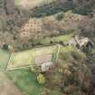
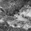
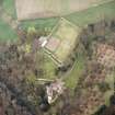
NT26SE 13.01 NT 2863 6364 Walled garden
NT26SE 13.02 NT 28985 63613 Lodge
NT26SE 13.03 NT 28650 63665 Fountainhead
See also NT26SE 12 and NT26SE 16.
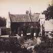
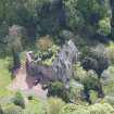
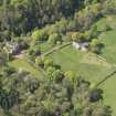
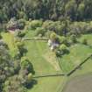
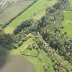
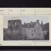
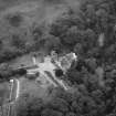
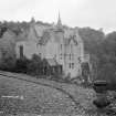
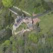
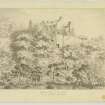
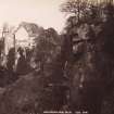
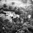
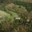
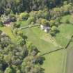
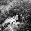
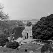
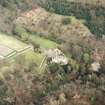
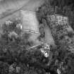
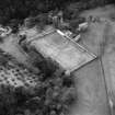
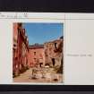
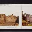
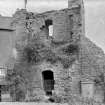
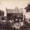
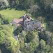
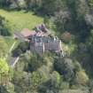
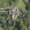
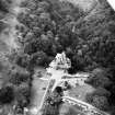
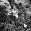
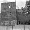
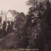
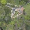
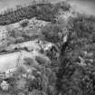
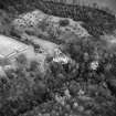
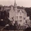
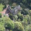
Hawthornden Castle occupies a strong position on a triangular promontory. The structure, as it now stands, is composed of a ruinous 15th century tower, to the N of which is attached an early 17th century house on the traditional L-plan. The old tower, ashlar-built and measuring c. 30' x 26', which has contained at least 3 storeys, is only a broken shell, with the remains of other buildings stretching to the W. The later house, which has been largely modernised and heightened, is of harled rubble, three storeys and a garret in height. A panel bearing a Latin inscription, near the doorway into the wing, which is dated 1795, states that the house was restored in 1638 by William Drummond, the poet.
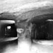
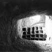
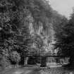
(For associated well and caves, see NT26SE 12 and NT26SE 16 ).
D MacGibbon and T Ross 1892; RCAHMS 1929, visited 1920; N Tranter 1962.
This castle is generally as described in previous information.
Visited by OS (SFS), 31 October 1975.
EXTERNAL REFERENCE:
Scottish Records Office:
Pen and Pencil sketch.
1851 GD38/1/1248A
Scottish Records Office:
RHP 13704
Plans of Hawthorden_D. Menzies
Field Visit (16 June 1920)
Hawthornden Castle.
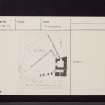
At Hawthornden, which is a mile north-east of and lower down the river North Esk than Roslin Castle, the stream winds through a deep and densely wooded gorge, the right bank of which exposes to the river a series of sandstone cliffs. At a turn of the stream, where the banks are precipitous, a rocky terrace juts out westward as a promontory and forms a very strong position for the castle which surmounts it, even though the ground to landward is considerably higher. In shape the site is roughly a triangle with a blunted apex. It measures rather less than 120 feet from east to west by 127 feet along the base and has on the west a height of 50 feet. Towards the southern end of the eastern side is a 15th-century tower, from which a screen wall returned to either extremity of the site, enclosing a slightly larger area than that now occupied by building. The 15th-century walling, which is ashlar in 12-inch courses of the stone composing the site, is seen returning from the tower southwards, where it is incorporated in a 16th-century structure, and then westwards, breasting the cliff to the extremity. Within the enclosure stand the ruins of the tower and of a hall, the latter on the southern side. Any contemporary structures which may have occupied the areas north and west of the tower have been removed or are obscured by the 17th-century mansion which now completes the enclosure.
The tower is quadrangular. It measures, externally, 30 1/3 feet from north to south by 26 feet from east to west, and has contained at least three storeys. At base a heavy ground course of chamfered members returns along the south wall, and also along the greater part of the east wall, where it has abutted on an upstanding rock, which rises to a height of 10 feet above the general level of the terrace and has been vertically scarped.
[see RCAHMS 1929 for a full architectural description]
RCAHMS 1929, visited 16 June 1920.

