
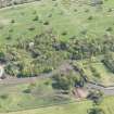
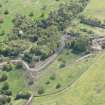
Edinburgh, Old Dalkeith Road, Edmonstone House


Boiler House (Period Unassigned)(Possible), Country House (Period Unassigned), Culvert (Period Unassigned), Gateway(S) (Period Unassigned), Ha Ha (Post Medieval), Rig And Furrow (Medieval) - (Post Medieval), Roman Road (Roman)(Possible), Track (Period Unassigned), Well(S) (Period Unassigned)(Possible)
Site Name Edinburgh, Old Dalkeith Road, Edmonstone House
Classification Boiler House (Period Unassigned)(Possible), Country House (Period Unassigned), Culvert (Period Unassigned), Gateway(S) (Period Unassigned), Ha Ha (Post Medieval), Rig And Furrow (Medieval) - (Post Medieval), Roman Road (Roman)(Possible), Track (Period Unassigned), Well(S) (Period Unassigned)(Possible)
Canmore ID 51744
Site Number NT26NE 70
NGR NT 2995 6990
Datum OSGB36 - NGR
Permalink http://canmore.org.uk/site/51744


- Council Edinburgh, City Of
- Parish Edinburgh (Edinburgh, City Of)
- Former Region Lothian
- Former District City Of Edinburgh
- Former County Midlothian
NT26NE 70 2995 6990
See also NT26NE 71 299 699 Ice House.
NT26NE 195 29760 69485 South Gates; West Gates
NT37SW 407 30374 70027 East Lodge
NT26NE 276 29772 69475 South Lodge; West Lodge
NT36NW 580 30013 69919 Sundial
NT26NE 385 29803 69813 Walled Garden
An archaeological evaluation took place on the site of Edmonstone House ahead of a proposed development of the area. A total of 8 trenches were excavated across the site. The trenches located in the footprint of the former mansion house revealed substantial remains and foundations. Examination of the stone foundations and wall remains revealed there had been a number of phases of building, with extensions added to the original mansion core. The main walls of the house had substantial foundations that extended 0.7m from the base of the walls. The foundations were built within a foundation trench, with the backfill still evident. A number of stone-lined culverts or drains were uncovered, with capping stones still in place. Numerous ceramic and iron pipes were also uncovered, found to be set within pipe trenches with a variety of backfill. Four of the archaeological trenches were excavated in the grounds of the former mansion house. It is landscaped, with grass cover and patches of mature trees. Nothing of archaeological significance was found in any of these trenches. It is hoped the footprint of Edmonstone House will be preserved in situ and not affected by the proposed development. There is a possibility of remains of earlier structures surviving on the site.
B Will 2005
NT 299 699 The evaluation, undertaken between August and September 2006, involved opening eight trial trenches to identify the location and level of survival of the now demolished mansion house. Substantial stone-built walls were uncovered in four of the trenches, enabling the extent of the surviving ground plan to be determined. The remaining trenches were in the grounds to the S and E of the house but no archaeological remains were uncovered.
Archive to be deposited in NMRS. Report to be lodged with City of Edinburgh Council Archaeology Service SMR and NMRS.
Sponsor: Boskabelle Ltd, through their agents Allan Murray Architects.
R Will and Alan Radley, 2006.
NMRS REFERENCE:
ARCHITECT: William Burn (Drawing Room, 1830)
Adam?
Edmonstone House has been demolished. Information from Demolitions catalogue held in RCAHMS library.
Archaeological Evaluation (January 2008)
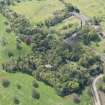
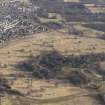
NT 299 699 (centred on) In January 2008 a survey and evaluation were undertaken ahead of proposed development. A photographic survey and recording programme were conducted to provide a general appraisal of the construction, character and condition of several surviving upstanding components of the designed landscape which surrounded the former Edmonstone House. These remains included an unconsolidated ha-ha (one of several on the estate) to the E of the extant stable block. The survey confirmed that the ha-ha had been adapted and repaired over time and is now in a poor state of repair. It also identified surviving structural
features, such as three former gateways and two possible abandoned wells on the eastern belt of the ha-ha. Three nonarchaeological sections previously cut through the ha-ha to the S of the stable block were cleaned and recorded. The sections showed that construction method of the ha-ha varied along its course, fitting the topography. Two further trenches were opened. The first, at the southern end of the estate, revealed the foundation of the ha-ha below an existing entranceway, suggesting that this opening was a later addition. Due to the lack of datable finds the date of the ha-ha is unknown. We carried out photographic recording and survey of a stonebuilt culvert, a series of wells and a sunken wall running N/S in the SE quadrant of the estate.
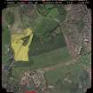
A total of 96 trenches were opened in March 2008 as part of a 5% evaluation of areas proposed for tree planting
throughout the estate. Substantial quantities of masonry were uncovered in four trenches.
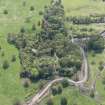
The stone foundations of a possible boiler house were revealed to the W of the estate’s walled garden. This garden may have been in place by the late 18th century; a complex ‘hot-wall’ system fed hot air through cavities in the walls and through pipes beneath the ground to heat the garden, allowing exotic plants to be cultivated (Montgomery, 1984). Further investigation may shed light on the processes involved in heating the former greenhouses next to the walled garden. NW of these foundations the remains of a substantial
sandstone wall were exposed.
A possible soak-away was found to the NW of the stable block, and we located the upper part of a stone-built culvert in the NW quadrant of the estate. A track leading to the stable block was exposed, revealing evidence of recent re-levelling and resurfacing in tarmac. This made the accurate recording of the sequence of construction difficult to determine. Rig and furrow indicated extensive agricultural activity across the site, and a number of trenches revealed stone-built field drains.
The evaluation also encountered numerous features, structures and deposits associated with mining, concentrated in the eastern part of the estate. Other modern uses of the landscape included demolition deposits and made ground surfaces, resulting from the construction of the ha-ha and estate boundary walls. NE of the stable block a shallow ditch exposed in three trenches appeared to be parallel to the ha-ha.
No evidence for prehistoric or medieval activity was found though on the E side of the estate three trenches revealed a possible Roman road [NT37SW 196 and NT37SW 1145]. A Roman road might be expected in this area, representing either the continuation of Dere Street, or a major spur from it leading on to the Forth-Clyde isthmus. However, no dating evidence was recovered and the remains were badly disturbed by both recent ploughing and mining. Further investigation would be required to confirm the date and route of the road.
Montgomery, G. (1984) A History of Newton Parish. Privately published.
Archive: RCAHMS (intended). Report: CECAS SMR and RCAHMS
Funder: Boskabelle Ltd
Charlotte Francoz and Alan Leslie (GUARD), 2008

