 |
On-line Digital Images |
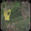
SC 692483 |
Scottish Development Department: Commissioned Aerial Imagery |
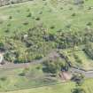
Vertical aerial view showing Moredun and Edmonstone districts, including the site of the new Edinburgh Royal Infirmary at Little France. |
15/5/1992 |
Item Level |
|
|
Manuscripts |
MS 2565 |
|
Report of an archaeological evaluation at Edmonstone House |
12/2005 |
Item Level |
|
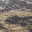 |
On-line Digital Images |
DP 085084 |
RCAHMS Aerial Photography Digital |
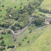
General oblique aerial view of Edmonstone House and policies and rig, looking SSE. |
1/3/2010 |
Item Level |
|
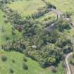 |
On-line Digital Images |
DP 188369 |
RCAHMS Aerial Photography Digital |
Oblique aerial view of Edmonstone House, looking W. |
2/5/2014 |
Item Level |
|
 |
On-line Digital Images |
DP 188371 |
RCAHMS Aerial Photography Digital |
Oblique aerial view of Edmonstone House, looking SSW. |
2/5/2014 |
Item Level |
|
 |
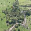
On-line Digital Images |
DP 188372 |
RCAHMS Aerial Photography Digital |
Oblique aerial view of Edmonstone House, looking S. |
2/5/2014 |
Item Level |
|
 |
On-line Digital Images |
DP 188373 |
RCAHMS Aerial Photography Digital |
Oblique aerial view of Edmonstone House, looking SE. |
2/5/2014 |
Item Level |
|
 |
On-line Digital Images |
SC 2442391 |
Records of the Ordnance Survey, Southampton, Hampshire, England |
Edinburgh, Old Dalkeith Road, Edmonstone House, NT26NE 70, Ordnance Survey index card, Recto |
c. 1958 |
Item Level |
|
|
All Other |
551 341/5/3/7 |
William Notman |
Plans, details, elevations and specifications for new offices at Edmonstone House |
|
Batch Level |
|
|
All Other |
MS 152/5 |
William Notman |
Specifications relating to Edmonstone House |
1821 |
Batch Level |
|


