Pricing Change
New pricing for orders of material from this site will come into place shortly. Charges for supply of digital images, digitisation on demand, prints and licensing will be altered.
South Hill Head
Settlement (Period Unassigned)
Site Name South Hill Head
Classification Settlement (Period Unassigned)
Canmore ID 51580
Site Number NT24SW 6
NGR NT 2127 4142
Datum OSGB36 - NGR
Permalink http://canmore.org.uk/site/51580
- Council Scottish Borders, The
- Parish Peebles
- Former Region Borders
- Former District Tweeddale
- Former County Peebles-shire
NT24SW 6 2127 4142.
(NT 2127 4142) Enclosure (NR)
OS 6" map (1965)
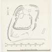
Two successive enclosures are situated on a shelf which extends between the W flank of South Hill Head and a steep slope, some 200' high, which here overlooks the Meldon Burn from the E. The larger enclosure, which may be assumed to be the earlier, measures 250' by 150' within a boulder faced rubble wall (I) originally about 10' thick Considerable stretches of the wall have been removed by former cultivation, and the rest has been heavily robbed, but an original entrance, 6' wide, can still be seen on the E.
The smaller enclosures, which lies entirely inside the larger one, measures 125' by 100' within a ruined boulder faced rubble wall (II) about 12' thick. The remains of the wall are overlain on the E, S and W by a sheepfold, while the NE sector has been entirely removed. That the two enclosures are of different dates is clearly indicated by the fact that there is no entrance on the E side of wall II to correspond with that in wall I; instead, the entrance to the inner enclosure is in the opposite W side, and, in order to give access to it, it has been necessary to clear a path at this point through the debris of wall I.
In the space between the two enclosures on the S there are several low stone banks, and a grass- covered rocky mound, the southern end of which is faced with boulders. These features are probably contemporary with the foundations of two rectangular stone buildings of no great age, one of which lies on the course of the robbed NE sector of the wall II, and the other 18 yards outside the enclosure on the E. The general similarity between these works and the enclosures described under NT24SW 15 is worth noting.
(Information from R W Feachem 1961, 21)
RCAHMS 1967, visited 1961
These enclosures are as described. They bear a marked similarity to NT24SW 15. The non-defensive position, overlooked on the E, rules out the possibility of a fort, but it is ideal for a settlement.
Visited by OS (BS) 23 September 1974
Reference (1957)
This site is noted in the ‘List of monuments discovered during the survey of marginal land (1951-5)’ (RCAHMS 1957, xiv-xviii).
Information from RCAHMS (GFG), 24 October 2012.
Sbc Note
Visibility: This is an upstanding earthwork or monument.
Information from Scottish Borders Council


