
Meldon Burn


Settlement (Prehistoric)
Site Name Meldon Burn
Classification Settlement (Prehistoric)
Alternative Name(s) White Meldon
Canmore ID 51531
Site Number NT24SW 15
NGR NT 2140 4290
Datum OSGB36 - NGR
Permalink http://canmore.org.uk/site/51531


- Council Scottish Borders, The
- Parish Peebles
- Former Region Borders
- Former District Tweeddale
- Former County Peebles-shire
NT24SW 15 2140 4290.
(NT 2140 4290) Earthwork (NR)
OS 6" map (1965)
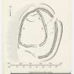
Two stone-walled enclosures, one of which has been built inside the other are situated on a broad natural terrace near the foot of the W slopes of White Meldon Hill.
The earlier enclosure (I) measures 220' by 180' and has been surrounded by a heavy wall, 12' in thickness, composed of a core of earth and small stones faced with boulders. Round the E half of the enclosure the remains of the wall now appear as a turf-covered bank standing up to 7' in height, with a considerable number of facing-stones still visible; a portion of the outer face on the SSE survives to a height of 2' 6" in three courses. The wall is accompanied by an external ditch which measures up to 6' in depth and 20' in width. Round the W half, however, the later enclosure has virtually destroyed the earlier structure; nothing can be seen of the ditch, and only slight traces of the wall remain, but its course is indicated by a slight terrace on the NW, and on the SW by an intermittent low scarp in which four outer facing-stones are visible. There are two entrances, each 10' in width and situated on the NE and S respectively, both of which appear to be original.
The later enclosure (II) measures 165' by 120' within a wall consisting of a rubble core faced with heavy angular blocks. It has been severely robbed, but portions of the lowest course of either face still visible in the collapsed debris indicate a thickness of 10'. There is a single entrance on the SW measuring 8' in width. The interior is featureless apart from a slightly raised platform at the N end.
Between the two walls on the NE two parallel settings of earthfast boulders, which extend across the intervening space at an interval of 50', appear to have been the footings of thin walls. Although they seem to be associated with one or other of the enclosures already described, their function is uncertain.
(Information from A McLaren notebook 1, 30)
RCAHMS 1967, visited 1959
A massive walled settlement as described.
Visited by OS (JLD) 2 May 1962 and (BS) 26 September 1974
Photographed by the RCAHMS in 1980.
Reference (1957)
This site is noted in the ‘List of monuments discovered during the survey of marginal land (1951-5)’ (RCAHMS 1957, xiv-xviii).
Information from RCAHMS (GFG), 24 October 2012.
Note (21 October 2015 - 20 October 2016)
This fort or fortified settlement occupies a shelf near the foot of the steep and boulder-strewn W flank of the White Meldon, capitalising upon an escarpment that forms the leading edge of the shelf above the E bank of the Meldon Burn to enhance the defences of its W flank. Oval on plan it measures about 68m from N to S by 52m transversely (0.31ha) within a single rampart 3.6m in thickness by up to 2.1m in height, which has long runs of outer face visible, at one point on the SSE still standing 0.7m high. An external ditch some 6m in breadth by 1.8m in depth has been cut around the uphill side on the E and has evidently been carried round the N flank and onto the escarpment on the W. One entrance lies on the NNE, with a clear causeway across the ditch, and there was probably a second on the S. No contemporary features are visible within the interior, over half of which is occupied by a scooped settlement, the construction of which is probably responsible for the mutilation of the earlier defences on the SSW. The settlement measures about 50m from N to S by 35m transversely within a wall that incorporates the earlier perimeter on the W, and the interior has been dug in deeply on the E. Various walls dividing the space between the settlement and the earlier defences on the E, a trackway that approaches from the N, and a series of small fields that overlie the ditch on the SSE, probably relate to the late Iron Age occupation of the scooped settlement.
Information from An Atlas of Hillforts of Great Britain and Ireland – 20 October 2016. Atlas of Hillforts SC3675
Sbc Note
Visibility: This is an upstanding earthwork or monument.
Information from Scottish Borders Council

