
North Queensferry, Harbour


Harbour (Period Unassigned)
Site Name North Queensferry, Harbour
Classification Harbour (Period Unassigned)
Alternative Name(s) North Queensferry Harbour; St Margaret's Haven; St Margaret's Bay; Queensferry Narrows; Queensferry Passage
Canmore ID 51025
Site Number NT18SW 98
NGR NT 1290 8030
NGR Description Centred NT 1290 8030
Datum OSGB36 - NGR
Permalink http://canmore.org.uk/site/51025


- Council Fife
- Parish Inverkeithing
- Former Region Fife
- Former District Dunfermline
- Former County Fife
NT18SW 98.00 centred 1290 8030
Location formerly cited as NT 13 80.
NT18SW 98.01 NT 12840 80249 Railway Pier (formerly entered as NT18SW 248.00)
NT18SW 98.02 NT 12840 80249 Watching Brief (formerly entered as NT18SW 248.01)
NT18SW 98.03 NT 13096 80274 'Town' or 'Ferry' Pier (formerly entered as NT18SW 112)
NT18SW 98.04 NT 13101 80331 'Town' or 'Ferry' Pier, Signal House (formerly entered as NT18SW 40)
NT18SW 98.05 NT 13129 80359 'Town' or 'Ferry' Pier, Royal Navy Signal House (formerly entered as NT18SW 39).
For corresponding harbour at South Queensferry (NT 13017 78545), see NT17NW 71.00.
For corresponding Hawes ('Ferry') Pier at South Queensferry, Lothian (NT 13633 78497), see NT17NW 172.00.
(Locations cited as NT 131 802 and NT 128 802). Ferry piers, North Queensferry, 19th century. Two ramped ferry piers and a wood-piled pier. The eastern ferry-pier has a neat hexagonal light tower at its shore end, c. 1810.
J R Hume 1976.
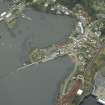
North Queensferry harbour, which is also known as St Margaret's Haven, is not defined by artificial construction, but instead comprises piers within St Margaret's Bay, on the N side of Queensferry Narrows or Queensferry Passage and to the of North Queensferry village (NT18SW 121). It is sheltered by the Long Craig rocks [name: NT 126 802] to the W and by the massive headland of Carlingnose Point to the E. The greater part of the harbour dries at Low Water, and a significant portion (around NT 1286 8040) on the E side of the Railway Pier (NT18SW 98.01) has been infilled.
Since the end of the vehicular ferry service (1964), the harbour has been used almost exclusively by leisure and recreational craft.
The Forth Rail Bridge (NT17NW 70) overarches the harbour.
Information from RCAHMS (RJCM), 6 March 2006.

