
Kirkliston, The Square, Kirkliston Parish Church


Church (12th Century), Dovecot (Post Medieval)
Site Name Kirkliston, The Square, Kirkliston Parish Church
Classification Church (12th Century), Dovecot (Post Medieval)
Alternative Name(s) Free Church
Canmore ID 50729
Site Number NT17SW 19
NGR NT 12480 74379
Datum OSGB36 - NGR
Permalink http://canmore.org.uk/site/50729


- Council Edinburgh, City Of
- Parish Kirkliston (City Of Edinburgh/w Lothian)
- Former Region Lothian
- Former District City Of Edinburgh
- Former County West Lothian
NT17SW 19.00 12480 74379
NT17SW 19.01 12563 74364 Hall
NT17SW 19.02 12494 74364 Churchyard
NT17SW 19.03 12511 74367 Watch house
NT17SW 19.04 12418 74349 Churchyard extension
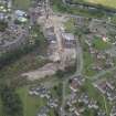
NT 124 743 A watching brief was carried out in July 1998 on two test pits excavated immediately adjacent to the NW and SW corners of the church tower (assumed date AD 1200), to examine the foundations because of movement of the tower. A raft of mortared masonry of late medieval date was seen to underpin the tower foundations, which were only 0.2m below current ground level. A small quantity of disarticulated human bone was discovered in an 18th-century wall trench, but there was no evidence of medieval burials within a metre of the tower walls.
Sponsor: City of Edinburgh Council.
D Henderson 1999
NT 1246 7439 Excavation of a small test pit (1 x 3m) was required in September 2004 to assess the depth of the foundations for the retaining wall and the church wall prior to proposed repair work on the retaining wall. Two large discrete collections of human bone, several other stray human bones, and a number of modern artefacts including pottery and drainpipes were discovered, along with one piece of medieval green-glazed ware.
The test pit determined a depth of 2.4m for the foundation of the retaining wall, though the church wall foundation continues below the depth of the test pit. The retaining wall is constructed of rough stone blocks and mortar, with at least one drainage slot through it, close to its base. It is c 1.75m high on the N side, bordering a private garden, but on the S side only 0.2-0.3m of the wall is visible above ground level. The church wall foundation is constructed of brick with a concrete base. The human bone was not studied and was re-interred during the backfilling of the test pit.
Report lodged with Edinburgh SMR and the NMRS.
Sponsor: City of Edinburgh Council Archaeology Service.
S Badger 2004
INVENTORY OF GRAVEYARD AND CEMETERY SITES IN SCOTLAND REFERENCE:
N.B. This reference applies collectively to NT17SW 19.00, NT17SW 19.02, NT17SW 19.03, NT17SW 245
Address: Kirkliston Parish Church and Burial Aisle, Churchyard, Churchyard extension/Cemetery and Cemetery, The Square, Kirkliston
Postcode: EH19 9AX
Status: In current use for burials
Size: Churchyard: 0.20 hectares, 0.49 acres; Churchyard extension/Cemetery: 0.44 hectares, 1.08 acres; Cemetery: 0.26 hectares, 0.64 acres
Polygon: No
TOIDs:
Number of gravestones: Not Known
Earliest gravestone: Not Known
Most recent gravestone: Not Known
Description: Church with burial aisle, burial ground associated with a church, modern cemetery.
Data Sources: OS MasterMap checked 12 September 2005; Bereavement Services Portal checked 12 September 2005
NT17SW 19.00 12480 74379
NT17SW 19.01 12563 74364 Hall
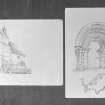
(NT 12480 74379) Kirkliston parish church, which has been considerably modernised and is still in use, contains considerable portion of the original fabric, dating from about 1200, which show detail showing the transition between Norman and Early English work. The older masonry is of cubical ashlar, axe-dressed, and is in a very fair state of preservation; of particular note is the S doorway, one of the finest fragments of late Transitional work in Scotland.
RCAHMS 1929, visited 1915
This church, still in use, is generally as described, the W side showing signs of renovation in recent years.
Visited by OS (BS) 12 August 1974
NMRS REFERENCE:
Also see under MLD/2 for architectural details filed with Hallyards Castle. Pen and Ink.1913.
NMRS REFERENCE
Plans: I G Lindsay Coll, W/435
Photographic Survey (1950)
Photographs of Kirkliston Parish Church, West Lothian, likely taken by the Ministry of Works c1950.
Dendrochronology
NT 12480 74379 Kirkliston Parish Church has early origins, retaining some Norman Transitional features, but has been much altered in post-medieval times. Following a lead from Rachel Pickering of HES, assessment revealed two re-used structural oak timbers above the top of the stairwell in the bellcote tower. These were cored and proved to be native oak felled in AD 1203, and they probably relate to the original construction of the church. Full details of the Kirkliston and other SESOD results will be given in the project publication. See also the SESOD overview (p6).
Archive: NRHE (intended)
Funder: Historic Environment Scotland
Coralie M Mills – Dendrochronicle
(Source: DES Volume 23)

