Accessibility

Font Size

100% 150% 200%

Background Colour

Default Contrast
Close Reset

Forth Road Bridge

Pier(S) (20th Century), Road Bridge (20th Century), Suspension Bridge (20th Century)

Site Name Forth Road Bridge

Classification Pier(S) (20th Century), Road Bridge (20th Century), Suspension Bridge (20th Century)

Alternative Name(s) Forth Bridge; River Forth; Queensferry Narrows

Canmore ID 50549

Site Number NT17NW 171

NGR NT 12535 79638

NGR Description NT 12468 78249 to NT 12589 80796

Datum OSGB36 - NGR

Permalink http://canmore.org.uk/site/50549

Ordnance Survey licence number AC0000807262. All rights reserved.
Canmore Disclaimer. © Bluesky International Limited 2025. Public Sector Viewing Terms

Toggle Aerial | View on large map

Digital Images

Forth Road Bridge
View of driving machine for cable spinning
Forth Road Bridge
View of driving machine for cable spinningNorth Queensferry, Town Pier
View looking SSW along pier with part of Forth Road Bridge in backgroundEdinburgh, Forth Road Bridge.
View from North West.
Digital image of A 37390 CN.Tower box section entering metallisation shop, drem Airfield
Copy of original 35mm colour transparency
Survey of Private CollectionCorner jacking compartment of South Main Tower climbing structure.
Copy of original 35mm colour transparency
Survey of Private CollectionAerodynamic damping device fro South Main Tower, supported on piles, west side of south viaduct.
Copy of original 35mm colour transparency
Survey of Private CollectionPontoon with footwalk support strand reel at South Jetty.
Copy of original 35mm colour transparency
Survey of Private CollectionUpstream footwalk support strands in main span. View north from top of South Main Tower.
Copy of original 35mm colour transparency
Survey of Private CollectionSpinning wheel crossing top of main tower. Handling crew gliding dead wires into saddle.
Copy of original 35mm colour transparency
Survey of Private CollectionWire adjustment control point at mid-span.
Copy of original 35mm colour transparency
Survey of Private CollectionMain towers with footwalks in main and side spans. View from South Queensferry pier.
Copy of original 35mm colour transparency
Survey of Private CollectionAn eight bolt cable band clamped on the downstream cable adjacent to South Main Tower.
Copy of original 35mm colour transparency
Survey of Private CollectionVisit by Prime Minister, the Rt. Hon. Harold McMillan with (left to right) Mr J R Dixon, Chairman of the A.D.C Bridge Co., Mr J A K Hamilton, Resident Engineer for Mott, Hay and Anderson, and Sir Hubert Shirley-Smith, Site Agent for the A.D.C. Bridge Co.
Copy of original 35mm colour transparency
Survey of Private CollectionView north of south side span and main span from south shore. Suspender and deck erection in progress.
Copy of original 35mm colour transparency
Survey of Private CollectionCleaning out galvanised duct pipes in south yard.
Copy of original 35mm colour transparency
Survey of Private CollectionView north of erection of main span suspended structure with two deck panels positioned in each roadway.
Copy of original 35mm colour transparency
Survey of Private CollectionView north east showing progress of erection of viaduct between north abutment and north side tower.
Copy of original 35mm colour transparency
Survey of Private CollectionPrgress of erection of suspended structure in main and side spans. View north west from south shore.
Copy of original 35mm colour transparency
Survey of Private CollectionSouth viaduct piers. View south from south causeway.
Copy of original 35mm colour transparency
Survey of Private CollectionSuspended structure in south side span showing safety net carriage and nets. View north from south side tower.
Copy of original 35mm colour transparency
Survey of Private CollectionCable wrapping machine on downstream cable at mid-span. Machine stabilised by 4 tackles to tram support strands.
Copy of original 35mm colour transparency.
Survey of Private CollectionSouth side span, south viaduct and toll area at night. View looking south from top of South Main Tower.
Copy of original 35mm colour transparency.
Survey of Private CollectionGeneral oblique aerial view centred on the railway bridge and road bridge with the pier adjacent, taken from the WNW.General oblique aerial view of North Queensferry with the Forth Bridges in the foreground, taken from the ESE.Firth of Forth, general view, showing Queensferry and Forth Rail Bridge.  Oblique aerial photograph taken facing north-west.General oblique aerial view of South Queensferry, Forth Rail Bridge and Forth Road Bridge, taken from the NW.General oblique aerial view of the new Forth crossing works site, taken from the SE.General oblique aerial view of Forth Rail Bridge, Forth Road Bridge, North Queensferry and construction of Queensferry Crossing, looking SW.General oblique aerial view of Carlowrie Country House with the runway in the foreground and the Bridges in the distance, looking N.Oblique aerial view during construction of the New Forth Bridge Crossing, looking to the S.General oblique aerial view of the River Forth centred on the new  Forth Bridge crossing, looking to the ESE.Oblique aerial view of the construction of the Queensferry Crossing, the Forth Road Bridge and Forth Rail Bridge, looking SSE.Oblique aerial view of the Forth Bridge, Forth Road Bridge and  construction of the Queensferry Crossing, looking NE.General oblique aerial view of the Upper Firth of Forth with The Queensferry Crossing construction, Forth Road bridge and Forth bridge in the distance, looking NE.Oblique aerial view of the construction of the new Queensferry Crossing, the Forth Road Bridge and South Queensferry, looking NNW.Forth Road Bridge Dalmeny, West Lothian, Scotland. Oblique aerial photograph taken facing North/East. Oblique aerial view.Oblique aerial view.Oblique aerial view.Oblique aerial view.Oblique aerial view.Oblique aerial view of the Queensferry Crossing on the day of the public pedestrian crossing.Oblique aerial view of the Queensferry Crossing on the day of the public pedestrian crossing.Oblique aerial view of the Queensferry Crossing on the day of the public pedestrian crossing, taken in 2016.Oblique aerial view.Oblique aerial view.A preliminary sketch design for the towers of the Forth Road Bridge by Giles Gilbert Scott (1880-1960).General oblique aerial view of the River Forth showing the construction site of the new Queensferry Crossing, the Forth Road and Rail bridges and Port Edgar looking to the NE.Edinburgh, Forth Road Bridge.
View from North approach viaduct.Edinburgh, Forth Road Bridge.
View from North approach viaduct of Forth Bridge, North East.Edinburgh, Forth Road Bridge.
View of South half of Road Bridge from Fife erection of Forth Bridge, North East.Edinburgh, Forth Road Bridge.
View of South half of Road Bridge from Forth Bridge, from East.South Queensferry, Forth Road Bridge.
View of South Queensferry from South approach viaduct of Forth Bridge.South Queensferry, Forth Road Bridge
View from top of South portal  of Forth BridgeOblique aerial view centred on the Forth Road Bridge with South Queensferry adjacent, taken from the NW.Forth Road Bridge general view, Firth of ForthForth Road Bridge from South, Firth of ForthView of section of Forth Road Bridge tower leaving Sir William Arrol's works.
Acc. No. 1987/2
Filed in Negative store
 Sir William Arrol Collection Box 13
Digital image of C87198/POHutments and storage area on the West wing of the North jetty. View from 4th lift, North Main Tower
Copy of original 35mm colour transparency
Survey of Private CollectionView North from South shore. Erection of South Main Tower commenced
Copy of original 35mm colour transparency
Survey of Private CollectionThree box sections erected, east leg, South Main Tower
Copy of original 35mm colour transparency
Survey of Private CollectionView up south face of South MAin Tower from jety. Cover plate being hoisyed between wire rope guides.
Copy of original 35mm colour transparency
Survey of Private CollectionStack of bridge wire coils in wire store.
Copy of original 35mm colour transparency
Survey of Private CollectionPontoon unreeling a footwalk support strand in mid-stream. View looking north.
Copy of original 35mm colour transparency
Survey of Private CollectionFloor and parapet mesh panels on partly constructed upstream footwalk in south side span.
Copy of original 35mm colour transparency
Survey of Private CollectionFootwalk  mesh erection in south side span. View north from from top of South Main Tower.
Copy of original 35mm colour transparency
Survey of Private CollectionUnreeling machines, counter-weight towers, and drums of bridge wire in Unreeling Area, South Working Area.
Copy of original 35mm colour transparency
Survey of Private CollectionTwo man crew on work-car suspended from upstream tram support strands. View north west from South Tower.
Copy of original 35mm colour transparency
Survey of Private CollectionSpinning wheel leaving south anchorage carrying two bights of bridge wire.
Copy of original 35mm colour transparency
Survey of Private CollectionSpinning wheel with 4 bights of wire passing mid-span. Construction of first upstream strand in progress.
Copy of original 35mm colour transparency
Survey of Private CollectionMain cable strands with temporary compression clamps.
Copy of original 35mm colour transparency
Survey of Private CollectionLive wire guide sheaves on upstream footwalk.
Copy of original 35mm colour transparency
Survey of Private CollectionRock-fill causeway to North Main Tower damaged by storm. View South.
Copy of original 35mm colour transparency
Survey of Private CollectionTreated road deck and footway panels in storage at Drem Airfield, East Lothian.
Copy of original 35mm colour transparency
Survey of Private CollectionCable compaction in progress on downstream cable in main span. Temporary galvanised steel straps at 750mm spacing.
Copy of original 35mm colour transparency
Survey of Private CollectionWinch installed at the South Main Tower for suspender erection.
Copy of original 35mm colour transparency
Survey of Private CollectionView north from top of South Main Tower. Tramway ropes slacked off for removal.
Copy of original 35mm colour transparency
Survey of Private CollectionErection of deck transverse girder on north side of South Main Tower.
Copy of original 35mm colour transparency
Survey of Private CollectionLong suspender ropes hung from  upstream and downstream cables in main span. View north from South Main Tower.
Copy of original 35mm colour transparency
Survey of Private CollectionConnection of suspender ropes to upper chord of suspended structure using hydraulic rams.
Copy of original 35mm colour transparency
Survey of Private CollectionGeneral view of erection of the south section of main span suspended structure. View north from mid-span.
Copy of original 35mm colour transparency.
Survey of Private CollectionTests on screeding a trial panel of side span roadway concrete in south working area.
Copy of original 35mm colour transparency.
Survey of Private CollectionFixing reinforcement in a downstream roadway deck panel in south side span. View north east.
Copy of original 35mm colour transparency.
Survey of Private CollectionConcreting a roadway deck panel on downstream side of south side span. View looking east.
Copy of original 35mm colour transparency.
Survey of Private CollectionProgress of concreting north side span roadway deck panels. Sequence of concreting to reduce to a minimum distortion of suspended structure.
Copy of original 35mm colour transparency.
Survey of Private CollectionGeneral view of the bridge with erection of penultimate panels on each side of main span in progress.
Copy of original 35mm colour transparency.
Survey of Private CollectionView north through stiffening trusses of main suspended structure.
Copy of original 35mm colour transparency.
Survey of Private CollectionErection of footway/cycle track panel on downstream side of main span.
Copy of original 35mm colour transparency.
Survey of Private CollectionThe main span deck from the top of the South Main Tower , showing erection of the roadway and footway/cycle track panels completed.
Copy of original 35mm colour transparency.
Survey of Private CollectionView of completed mastic asphalt surfacing of the upstream roadway in main span.
Copy of original 35mm colour transparency.
Survey of Private Collectionthe Forth Road Bridge opening ceremony. Arrival of H M The Queen.
Copy of original 35mm colour transparency.
Survey of Private CollectionGeneral oblique aerial view centred on the road bridge, suspension bridge, piers and railway bridge, taken from the WSW.Oblique aerial view centred on the railway bridge and road bridge with the pier, breakwaters and harbour adjacent, taken from the WSW.General oblique aerial view centred on the Forth Bridge and the Forth Road Birdge, taken from the WSW.Forth Road Bridge under construction, oblique aerial view.General oblique aerial view centred on the rail and road bridges, taken from the S.Oblique aerial view centred on the Forth Bridge with the Forth Road Bridge adjacent, taken from the NE.General oblique aerial of the new Forth crossing works site, taken from the WNW.Oblique aerial view of Dundas Park Golf Course with the Forth Rail and Road Bridges beyond, taken from the SSW.General oblique aerial view of North Queensferry, Forth Bridge and Forth Road Bridge, taken from the NW.

First 100 images shown. See the Collections panel (below) for a link to all digital images.

Administrative Areas

  • Council Edinburgh, City Of
  • Parish Dalmeny
  • Former Region Lothian
  • Former District City Of Edinburgh
  • Former County West Lothian

Treasured Places

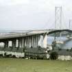
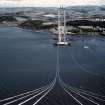
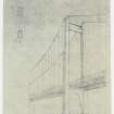
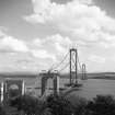
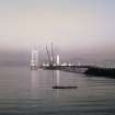
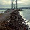
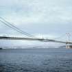
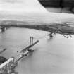
In 1958 construction began of the Forth Road Bridge, and it was officially opened by the Queen in 1964. The architects were Sir Giles Gilbert Scott & Partners and the consultant engineers were Mott, Hay & Anderson and Freeman Fox & Partners.

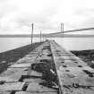
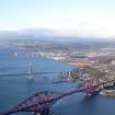
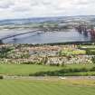
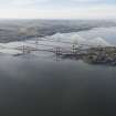
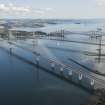
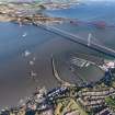
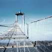
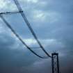
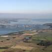
The suspension bridge comprises two 150m high steel towers which carry cables supporting the road; further support is supplied by concrete arches close to the shore at each side. The bridge spans some 1.8km between North and South Queensferry.

Information from RCAHMS (SC) 27 June 2007

McWilliam, C 1978

Archaeology Notes

NT17NW 171.00 12535 79638 (NT 12468 78249 to NT 12589 80796)

The Forth Road Bridge (Toll) [NAT]

OS 1:10,000 map [no date available].

NT17NW 171.01 NT 12439 78049 Toll

For Forth Rail Bridge (NT 1390 7790 to 1315 8082), see NT17NW 70.

For wreck of SS Telesilla (adjacent to North Pier), see NT18SW 8004.

NMRS REFERENCE:

Non-Guardianship Sites Plan Collection, DC23753.

(Undated) information in NMRS.

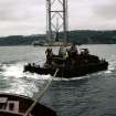
The Dumbarton ship building firm of William Denny & Brothers Ltd, in conjunction with British Railways operated the ferry service between North and South Queensferry on the Firth of Forth. In 1934, Denny built two ships for the ferry, these were joined by a further two vessels, also built by Denny, in 1949 and 1956. During the summer months all four vessels provided a frequent service. A three boat service operated during the winter months.

Information from The Royal Burgh of Dumbarton, The Official Guide, Sixth Edition, c.1960.

(Location cited as NT 124 782 to 126 808). Suspension bridge of parallel wire cables type. Built 1958-64 by Freeman, Fox & Partners, engineers. Steel girder pylons. Single spun wire cable on each side, wire rope suspenders, deep truss deck. Clear span 3,300 ft (1006m), total span 5,980 ft (1823m). Public road bridge.

J R Hume 1977b.

Mott, Hay & Anderson began their report on the feasability and siting of the road bridge in 1926. The Joint Board set up in 1947 confirmed their appointment as consulting engineers together with Freeman, Fox & Partners, Giles Gilbert Scott & Partners being the consultant architects. The site was one of those originally recommended, using the Mackintosh Rock on the N side to support one of the two towers of a suspension bridge. Treasury authority was given in 1958 and the Queen opened the bridge in 1964.

It was not a pioneer work of its kind like the rail bridge (NT17NW 70), and its design owed much to previous experience, not least to the lesson of the Tacoma Narrows bridge, USA, which collapsed as a result of rhythmic movement induced by wind pressure. This is one reason for the absence of continuous surfaces to the sides, which in turn contributes to the main quality of the bridge if it is seen as a work of architecture.

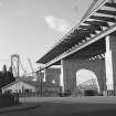
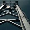
The carriageway, unlike that of the rail bridge, is predominant, rising and falling in an easy curve 1830m in length between the box girders of the approach viaducts; the main span accounts for just over 1000m of this. The only other elements are the two steel towers, 150m high, simply latticed between their slightly tapering legs, which carry saddles for the cables whose calligraphic curve complements that of the carriageway, and then disappears underneath it to anchorages in the rock. The only suspicion of 'applied architecture' is the design of the arched concrete piers, whose job is not only to carry the last girders of the approach, but also to take the eccentric strain of the cables before they run to ground. The dual carriageway is supported by lattice trusses, elegantly pointed at the extreme ends.

The experience of crossing it, attaining the greatest height at the furtest distance from land, is made less exciting (but doubtless safer) by the steel grid crash-barriers blocking the sideways and downwards view; the slightly later Severn Bridge improved on this. Cross-girders outside the trusses support a track for cyclists and pedestrians. Undoubtedly the best way to see the bridge, and the views from it, is to walk.

The Administration Building at the S end, with curved-up eaves that are not inappropriate to the levitation effect of the bridge itself, is by Giles Gilbert Scott & Partners. Wheeler & Sproson added the garages for service vehicles in 1969, tactfully concealing them to avoid clutter.

C McWilliam 1978.

Spans Forth from South Queensferry and North Queensferry. Undergoing repairs.

Site recorded by GUARD during the Coastal Assessment Survey for Historic Scotland, 'The Firth of Forth from Dunbar to the Coast of Fife' 18th February 1996.

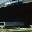
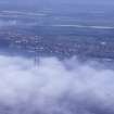
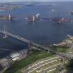
This bridge carries the A90 (T) public road across the inner estuary of the River Forth at the Queensferry Narrows, between the parishes of Dalmeny (in the former county of West Lothain and City of Edinburgh District of Lothian Region) and Inverkeithing (in the former county of Fife and Dunfermline District of Fife Region). There are toll booths and an administration building at the S end.

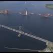
This bridge forms a notable panorama with the corresponding rail bridge (NT17NW 70) which stands a short distance to the E. The N ends of the two bridges lie close together, but they diverge towards the S, the village of South Queensferry (NT17NW 175) lying between them. Like the rail bridge, this bridge over-arches the village of North Queensferry (NT18SW 121).

The location assigned to this record defines the midpoint of the structure. The available map evidence indicates that it extends from NT c. 12468 78249 to NT c. 12589 80796.

Information from RCAHMS (RJCM), 3 March 2006.

The Forth Road Bridge (toll) [NAT]

OS (GIS) MasterMap, December 2010.

Activities

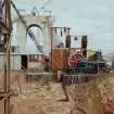
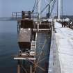
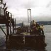
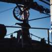
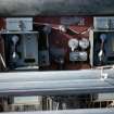
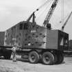
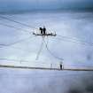
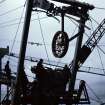
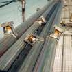
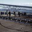
Photographic Record (1958 - 1964)

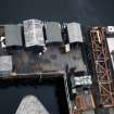
Photographs taken during the construction of the Forth Road Bridge.

Construction (1958 - 1964)

Bridge built 1958-1964 by Freeman, Fox and Partners, engineers.

C McWilliam 1978.

Principle contractors were A.C.D. Bridge Co. (superstructure) and John Howard and Co. Ltd (foundations). Freeman, Fox and Partners and ott, Hay And Anderson were consulting engineers.

R Paxton and J Shipway 2007.

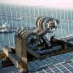
Photographic Record (1960 - 1969)

Photos taken in the 1960s by Andrew Simpson, scanned and contributed to RCAHMS.

Three sites:

CRUACHAN PUMP STORAGE DAM

Four Photographs.

Scanned from Mono-chrome negatives.
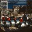
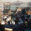
FORTH ROAD BRIDGE

Six Photographs.

Scanned from Mono-Chrome negatives.

RIVER CLYDE

Two Photographs

Scanned from 35mm Kodachrome.

(A) Construction of QE2

400mm Telephotograph from Great Western Rd.

(B) General Terminus Quay

Ore Carrier, Bulk Handling Cranes and Ferry at General Terminus Quay, Glasgow

Photographic Record (4 September 1964)

Photographs taken during the opening of the Forth Road Bridge.

Photographic Record (1964)

Photographs taken in 1964 during an informal site visit.

Standing Building Recording (28 April 1982)

Undertaken as part of the Scottish Industrial Archaeology Survey

Standing Building Recording (16 April 1983)

Aerial Photography (1 January 1987 - 31 December 1987)

Aerial Photography (1 January 1988 - 31 December 1988)

Aerial Photography (8 May 2000)

Aerial Photography (2 December 2004)

Aerial Photography (13 June 2004)

Project (2007)

This project was undertaken to input site information listed in 'Civil engineering heritage: Scotland - Lowlands and Borders' by R Paxton and J Shipway, 2007.

Publication Account (2007)

A road bridge at Queensferry was first proposed in the 1920s and in 1926 the Ministry of Transport invited Messrs Mott, Hay & Anderson to prepare a design but no action was taken. In 1934–35 proposals were made for a bridge at different sites, including one half a mile upstream from the railway bridge, at Mackintosh Rock. But the war intervened and it was not until 1947 that the government gave permission for the Forth Bridge Joint Board to obtain proposals and prepare for construction. At this time the estimated cost of the bridge was £6.2 million.

Because of the depth of water at the bridge site at Mackintosh Rock, foundations in mid-channel were impracticable. A navigational headroom of 150 ft was required for access to Rosyth Dockyard. These considerations gave rise to a design for a long-span suspension bridge. The Forth Road Bridge was thus to be the first long-span suspension bridge built in Great Britain in modern times.

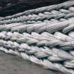
The construction of the bridge was to be the first use in Britain of ‘cable spinning’, by which small-diameter wires are laid side by side in large numbers and then bound together to form a single cable. Much of the technical expertise for this work was derived from USA practice. Wind tunnel tests on a model of the bridge showed that to restrict undesirable oscillations the bridge deck would require longitudinal vents along its full length to assist the dispersal of wind effects.

The construction of the bridge took place from 1959–64 and the bridge was opened on 4 September 1964. It was then the first in the world with a span of over 1 km not designed and built by American engineers, and the longest span bridge in Europe. The consulting engineers were Mott,Hay & Anderson and Freeman, Fox & Partners. The main contractorswere John Howard & Co. Ltd for the foundations, and the A. C. D. Bridge Co. for the superstructure. This latter firmwas a combination of SirWmArrol&Co. Ltd, Cleveland

Bridge Engineering Co., and Dorman Long & Co.

The principal dimensions are:

Main span 3300 ft

Side spans 1340 ft

South approach viaduct 1437 ft

North approach viaduct 842 ft

Total length of bridge between abutments 8259 ft

Height of main towers above mean tide level 512 ft

Diameter of cables 2 ft

No. of wires in each cable 11 618 (dia. 0.196 in.)

Total length of wire in both cables 30 800 miles

Sag/span ratio 1 :11

Navigational clearance under main span 150 ft

Carriageway width 24 ft

Cycle track width 9 ft

Footway width 6 ft

Total weight of steel in the bridge 39 000 tons.

R Paxton and J Shipway 2007

Reproduced from 'Civil Engineering heritage: Scotland - Lowlands and Borders' with kind permission of Thomas Telford Publishers.

Photographic Survey (2016)

Photographic survey images by HES, 2016.

References

MyCanmore Image Contributions


Contribute an Image

MyCanmore Text Contributions