|
Photographs and Off-line Digital Images |
B 98356 CS |
|
Plate 1 from J Mothersole (1927) 'In Roman Scotland'. |
1927 |
Item Level |
|
|
Photographs and Off-line Digital Images |
WL 1912 PO |
|
General view |
|
Item Level |
|
|
Photographs and Off-line Digital Images |
WL 1913 PO |
|
General view |
1979 |
Item Level |
|
|
Photographs and Off-line Digital Images |
WL 2102 |
|
General view |
|
Item Level |
|
|
Manuscripts |
MS 725/138 |
Historic Scotland Archive Project |
Report of coastal assessment survey for Historic Scotland: The Firth of Forth from Dunbar to the border of Fife. (3 volumes)
Revised version with amended text. |
1996 |
Item Level |
|
|
Manuscripts |
MS 2221/05 |
Historic Scotland Archive Project |
Survey archive: List of Vertical Aerial Photographs consulted in the NMRS, from Coastal Assessment Survey, 'The Firth of Forth from Dunbar to the Coast of Fife'. |
1996 |
Item Level |
|
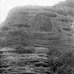 |
On-line Digital Images |
SC 1131765 |
J W Paterson |
General view of sculpture at Eagle Rock. |
c. 1920 |
Item Level |
|
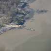 |
On-line Digital Images |
DP 250978 |
Historic Environment Scotland |
Oblique aerial view. |
27/3/2017 |
Item Level |
|
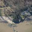 |
On-line Digital Images |
DP 250979 |
Historic Environment Scotland |
Oblique aerial view. |
27/3/2017 |
Item Level |
|
 |
On-line Digital Images |
SC 2439702 |
Records of the Ordnance Survey, Southampton, Hampshire, England |
Eagle Rock, NT17NE 11, Ordnance Survey index card, page number 1, Recto |
1958 |
Item Level |
|
 |
On-line Digital Images |
SC 2439703 |
Records of the Ordnance Survey, Southampton, Hampshire, England |
Eagle Rock, NT17NE 11, Ordnance Survey index card, page number 2, Verso |
1958 |
Item Level |
|
 |
On-line Digital Images |
SC 2439704 |
Records of the Ordnance Survey, Southampton, Hampshire, England |
Eagle Rock, NT17NE 11, Ordnance Survey index card, Recto |
1958 |
Item Level |
|
 |
On-line Digital Images |
SC 2439705 |
Records of the Ordnance Survey, Southampton, Hampshire, England |
Eagle Rock, NT17NE 11, Ordnance Survey index card, Recto |
1958 |
Item Level |
|
|
Manuscripts |
MS 2221/01 |
Historic Scotland Archive Project |
Survey archive: Photographic register from Coastal Assessment Survey, 'The Firth of Forth from Dunbar to the Coast of Fife'. |
1996 |
Batch Level |
|
|
Photographs and Off-line Digital Images |
BP 55/07 CN |
Historic Scotland Archive Project |
Survey photographs: Eagle Rock and other features on the coast between Cramond and S. Queensferry including World War 2 defences at Hound Point and Barnbougle Castle; Forth Rail Bridge; Hawes Inn, garage, pier with lighthouse; buildings in S.Queensferry itself.
Geology unit 22 and erosion unit 25 at Cramond, gology unit 20 at Long Green Beach, erosion unit 21 at Barnbougle, erosion units 18 and 19 at Pedraught Bay. |
1996 |
Batch Level |
|
|
Photographs and Off-line Digital Images |
BS 47/07 CS |
Historic Scotland Archive Project |
Survey photographs: Wooden posts W. of river Almond estuary; Eagle Rock and other features on the coast between Cramond and S. Queensferry including World War 2 defences at Hound Point and Barnbougle Castle; Forth Rail Bridge; Hawes Inn, garage, pier with lighthouse; buildings in S.Queensferry itself.
Geology unit 22 and erosion unit 25 at Cramond, gology unit 20 at Long Green Beach, erosion unit 21 at Barnbougle, erosion units 18 and 19 at Pedraught Bay. |
1996 |
Batch Level |
|
|
Manuscripts |
MS 2221/02 |
Historic Scotland Archive Project |
Survey archive: Record sheets from Coastal Assessment Survey, 'The Firth of Forth from Dunbar to the Coast of Fife'. |
1996 |
Batch Level |
|
|
Manuscripts |
MS 2221/03 |
Historic Scotland Archive Project |
Survey archive: Record sheets and maps of Erosion Units, from Coastal Assessment Survey, 'The Firth of Forth from Dunbar to the Coast of Fife'. |
1996 |
Batch Level |
|
|
Manuscripts |
MS 2221/04 |
Historic Scotland Archive Project |
Survey archive: Record sheets and maps of Geology and Coastal Geomorphology Units , from Coastal Assessment Survey, 'The Firth of Forth from Dunbar to the Coast of Fife'. |
1996 |
Batch Level |
|
|
All Other |
551 166/1/1 |
Records of the Ordnance Survey, Southampton, Hampshire, England |
Archaeological site card index ('495' cards) |
1947 |
Sub-Group Level |
|


