
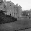
Hatton House


Country House (17th Century), Tower House (Medieval)
Site Name Hatton House
Classification Country House (17th Century), Tower House (Medieval)
Alternative Name(s) Hatton Estate; Old Argyle House; Haltoun House
Canmore ID 50361
Site Number NT16NW 5
NGR NT 1285 6881
Datum OSGB36 - NGR
Permalink http://canmore.org.uk/site/50361


- Council Edinburgh, City Of
- Parish Ratho
- Former Region Lothian
- Former District City Of Edinburgh
- Former County Midlothian
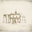
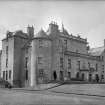
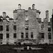
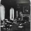
Hatton House, 1678 (demolished, 1955)
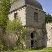
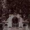
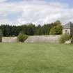
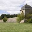
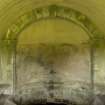
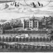
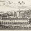
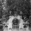
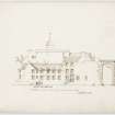
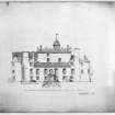
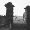
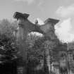
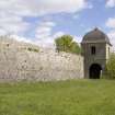
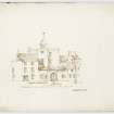
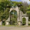
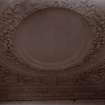
One of the great Renaissance houses of Scotland expanded from an original tower and later Renaissance courtyard by Lord Charles Maitland, brother of the Duke of Lauderdale. It became a great rectangular mansion, circular towers on each corner, its main tower turned into an enormous balustraded viewing platform at the centre. Its surrounding policies were equally imposing - parterres, formal gardens and wilderness - some traces of which - including the ogee-roofed pavilions at each end - remain. Most splendid survival is the magnificent winged gates.
Taken from "West Lothian: An Illustrated Architectural Guide", by Stuart Eydmann, Richard Jaques and Charles McKean, 2008. Published by the Rutland Press http://www.rias.org.uk

(NT 1285 6881) Hatton House (NR)
OS 6" map (1958)
Burnt out (1952) and demolished (1955).
ARCHITECT:
Robert Rowand Anderson - restoration (1870s)
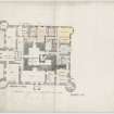
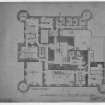
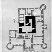
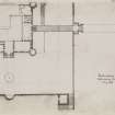
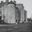
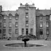
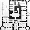
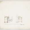
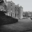
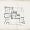
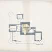
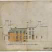
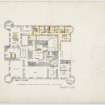
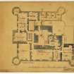
Hatton House: The present mansion is a plain, rectangular structure of the later 17th century, round a 15th century L-shaped tower.
The 17th century additions were made by Charles Maitland; and a wrought iron vane bears the monogram of himself and his wife, whom he married in 1652. The tower may, in part, represent 'the tower of Haltone' which was besieged in 1453. There is said to have been a royal licence in 1515 to William de Lauder to fortify or re-edify his house at Halton (J R Findlay (1875).
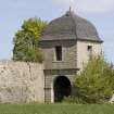
On the main approach from the Glasgow road is a Renaissance gateway bearing the date 1692. It was moved to this position in 1829 from its original site, farther east, at the entrance to the mile-long avenue which led westwards in a straight line, and terminated in the forecourt of the house.
RCAHMS 1929, visited 24 July 1913
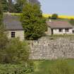
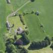
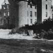
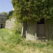
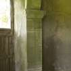
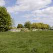
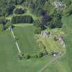
Hatton House has recently been demolished except for 20th century wing not shown on the RCAHMS plan. All that remains of the 17th century building is a fragment of the west wall where it joins the modern building and four courses of the south wall.
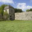
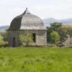
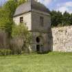
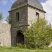
The garden wall and the two square towers which were part of the 17th century complex still remain. The Renaissance gateway is at NT 1280 6844. Nothing remains of the 15th century tower.
Visited by OS (JTT) 19 August 1965
NMRS REFERENCE:
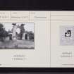
Engraved view of Hatton House, Midlothian
Insc: 'Old Argyle House'
Unsigned, not dated Acc. no.1993/89
REFERENCE:
Hatton House was bought by Captain William Davidson (also of Muirhouse, see NT27NW 18) in 1796 for £21,300 and was sold in 1870 for £42, 000 to the Earl of Horton.
See The Davidson's of Muirhouse Album in RCAHMS Print Room for written description of the Hatton Estate.
See also:
NT16NW 5.01 12864 68748 Bath House
NT16NW 5.02 12710 68752 Temple
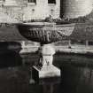
NT16NW 5.03 12830 68768 Terrace and Fountain
NT16NW 5.04 128 688 Garden; sundials
NT16NW 5.05 12799 68444 Entrance Gates
NT16NW 5.05 12822 68735 West Pavilion
NT16NW 5.06 12920 68760 East Pavilion
NT16NW 28 13908 68970 East Gates
Photographic Survey (26 October 1954)
Photographic survey of Hatton House, Midlothian, by the Scottish National Buildings Record/Ministry of Work in October 1954.
Photographic Survey (1954)
Photographic survey by the National Buildings Record Scottish Council in 1954.
Photographic Survey (June 1964)
Photographic survey of the south entrance gate to Hatton House, Midlothian, and of the grotto, by the Scottish National Buildings Record/Ministry of Work in June 1964.
Field Visit (15 August 2009)
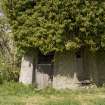
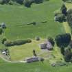
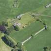
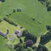
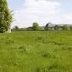
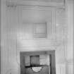
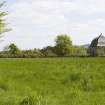
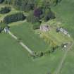
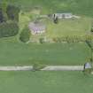
Hatton House has been demolished and levelled. The old building’s foundations survive in part to at least 1.5m below ground and remnants of the outer walls are partially extant on the south and west sides. These exposed walls include the base of the two turrets and the main entrance porch. An arched culvert opens out from the wall immediately east of the west turret. The walls on the south side are overgrown and are in a poor state of repair. The present house is a T-shaped bungalow occupying the west side of the foundation platform of the manor house. The west wall of the bungalow is built over the foundations of the west wall of the manor, incorporating them into storerooms built below. In the west face of a modern wall on the west side of the bungalow is a wall sundial dated 1675. The date includes a monogram made up of the letters CMEL (Charles Maitland and Elisabeth Lauder). Northeast of the bungalow is a modern barn or shed. East of this are two more barns, forming a long range in the old east drive.
Archaeological Services Durham University, 15 September 2009. OASIS-id: archaeol3-64466
Project (15 September 2009)
An archaeological desk-based assessment, field recording and geophysical surveys were conducted in advance of a proposed development at Hatton House, Ratho. The assessment included a search of databases, documentary, photographic and cartographic records and a field visit. Existing structures within the study area were recorded and described. The geophysical evaluation comprised geomagnetic and electrical resistance surveys in the area of proposed new-build.
The study area covers an area of approximately 25 hectares and is bounded by fields to the north and east, a lane to the west and the A71 road to the south. The proposed development area comprises a landscaped terrace immediately south of the site of the original Hatton House and the existing bungalow.
The works were commissioned by Holmar Property Developments.
Archaeological Services Durham University. 15 September 2009. OASIS-id: archaeol3-64466

