
Scheduled Maintenance
Please be advised that this website will undergo scheduled maintenance on the following dates: •
Tuesday 3rd December 11:00-15:00
During these times, some services may be temporarily unavailable. We apologise for any inconvenience this may cause.
Kaimes Hill


Fort (Prehistoric)
Site Name Kaimes Hill
Classification Fort (Prehistoric)
Canmore ID 50329
Site Number NT16NW 2
NGR NT 1315 6655
Datum OSGB36 - NGR
Permalink http://canmore.org.uk/site/50329


First 100 images shown. See the Collections panel (below) for a link to all digital images.
- Council Edinburgh, City Of
- Parish Ratho
- Former Region Lothian
- Former District City Of Edinburgh
- Former County Midlothian
NT16NW 2 1315 6655.
(NT 1315 6655) Fort (NR)
OS 1:10000 map (1977)
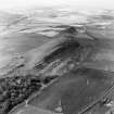
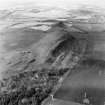
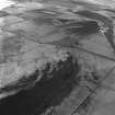
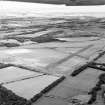
The fort on Kaimes Hill is being destroyed by quarrying which will ultimately remove the whole of the hill. It was first planned by Coles (1896) and later by the RCAHMS before quarrying started. The first excavations were carried out by Childe (1941) in 1940, and further excavations have taken place from 1964-72. In 1967, only the ramparts on the S and W sides of the hill were still preserved. Here, ground surveys and aerial photographs have revealed lines of ramparts, numbered 1 - 7 from those on the summit to the outermost.
The excavations revealed three main structural phases, starting with a univallate, timber-laced fort represented by rampart 1. The outer face of this rampart survived to a height of 5ft, but the inner face was marked only by a number of massive slabs, not set contiguously; the thickness was approximately 12 ft; the core of the rampart was composed of a number of stones, some vitrified, and occupation debris including slag and animal bones. Traces of carbonised timbers were also noted at its base.
In phase 2, rampart 1 was replaced by a rubble-cored, stone-faced rampart (no. 2) which in some areas overlay rampart 1 and in other areas lay immediately in front of it; the entrance through rampart 1 was remodelled. Ramparts 3 and 4, which survive in a fragmentary state, are similar in plan and are probably contemporary. A radio-carbon date of 365 +/- 90 BC was obtained from some twigs from the core of rampart 2. The final phase consists of the rubble and turf rampart 7 as its major structure and ramparts 5 and 6 at the E end of the hill. The entrances at the E and SE corner are simple structures and the gaps in the E end of ramparts 1 - 4 which continue the line of the entrances through 5 - 7 may also have been constructed at this time. The main object of these additional ramparts appears to have been to enclose the platform on the NE side of the hill on which at least 15 hut circles are visible, marked by stone footings and turf-covered banks.
South of rampart 7 and east of the entrance a series of stone slabs - chevaux de frise - projects from the turf and can be traced down the slope for some 100ft.
Among the huts, excavated, one overlay rampart 1; an anomalous radio-carbon date of 1191 +/- 90 BC was obtained from a piece of carbonised wood found in its wall filling.
Many artifacts, now in the National Museum of Antiquities of Scotland (NMAS), have come from this site, either as stray finds or from the excavations. Among them are: microliths, cup-and-ring marked stones (casts in the NMAS), various jet, flint, and stone artifacts, Iron Age pottery, Roman pottery (of 3rd century AD date) and a denarius of Severus.
D D A Simpson 1969; RCAHMS 1929, visited 1927; P R Ritchie 1970; DoE 1969; 1971; 1972; Proc Soc Antiq Scot 1974; 1975; G Macdoald 1918; A S Robertson 1970
Surveyed at 1:2500.
Visited by OS (JTT) 24 August 1965
(See also NT16NW 18).
Site quarried away by May 1986.
Excavation (June 1940 - July 1940)
Supervised excavations by the Ancient Monuments Board in 1940.
V G Childe 1941
Aerial Photography (April 1967)
Oblique aerial photographs of Kaimes Hill Fort, Midlothian, photographed by John Dewar in April 1967.
Note (3 November 2015 - 3 April 2017)
The greater part of the fort that stood on Kaimes Hill has been quarried away and now only a minor fragment of the ENE end survives beyond the disused N face of the quarry. Its defences were evidently complex, representing multiple phases, and it would be naive to believe that the true sequence of their construction and dates are understood from the rescue excavations conducted in 1940 at the WSW end under the supervision of Gordon Childe (1941), and more recently at the SSE side and at the ENE end from 1964 to 1972 by Derek Simpson (1969). Nevertheless, the circuits break down into two main elements, namely an inner and an outer enclosure, the former enclosing a roughly oval area measuring about 165m from E to W by 65m transversely (0.85ha), and the latter a less regular 260m from ENE to WSW by 120m transversely (2.3ha). Both Childe and Simpson found that the circuit of the inner enclosure had been adopted on at least two occasions, and that an earlier rampart had been partly demolished and replaced on a slightly different line. Childe also found another rampart buried on the slope below, with midden deposits built up against its rear and rubble from the later reconstruction apparently collapsed across it; on these grounds he assigned it to the earlier phase, though its course is concentric to the reconstructed circuit rather than the earlier line. Simpson likewise showed that the perimeter of the inner enclosure incorporated the remains of two ramparts, the core of the earlier of which contained burnt earth, some vitrified stones, and domestic debris and covered traces of burnt timbers at its base. The rampart that replaced it was itself of two periods of construction, the first a drystone wall, which was subsequently encased in a thicker deposit of earth and rubble with a massive outer face. At the entrance midway along the SSE side, the facing of the terminal of the earliest rampart had been carried into the interior, and in the later reconstructions this seems to have formed the rear face of a built inturn. Like Childe, he also identified a series of additional ramparts on the slope outside the inner circuit, mainly outside the entrance at the E end and largely hidden beneath the later occupation represented by numerous later stone-founded round-houses that existed around the S margin of the inner enclosure and sprawled across the defences down across the interior of the outer enclosure at the at the ENE end. The continuity of the circuit of the outer enclosure is represented by what is generally its outermost rampart, and it is not fully understood how this related to the two ramparts placed concentrically within it at the ENE end, or indeed to yet another rampart which detaches itself on the E to swing on a wider arc round the ENE end down to the cliff-edge on the N. Simpson made sense of this by assuming that the outermost rampart dug by Childe at the W end was the innermost of these ramparts at the ENE end (Simpson's rampart 5), but Childe believed he had excavated the outermost rampart shown on the various plans by Fred Coles (1896, 270, fig 1) and the RCAHMS investigators (1929, 160-2, no.216, fig 199) and identified by Simpson elsewhere as his rampart 7. The sequence of enclosure is evidently more complex than has been revealed by survey and excavation. Nevertheless, the outermost rampart was clearly an important circuit at some stage in the fort's history, pierced by entrances on the ENE, E and S, though not in the apparent gap tested by Simpson below the S entrance of the inner enclosure; the enhanced belt of defences at the ENE end flanks both the ENE and E entrances, and from the latter the route to the summit evidently passed through the complex of ramparts outside the E entrance of the inner enclosure. The outer enclosure was also accompanied by a chevaux de frise, which was identified on the RCAHMS plan at two points along the SSE side; in the area uncovered by Simpson, however, it was not a continuous belt. The main evidence of occupation within the fort is represented by stone-founded round-houses, two of which were excavated by Childe and others by Simpson. Some clearly overlie ramparts, as was first demonstrated by Childe, but in view of the uncertainties about the complete structural history of the defences, it would be unwise to assume that this represents a phase of essentially unenclosed or undefended settlement.
Information from An Atlas of Hillforts of Great Britain and Ireland – 03 April 2017. Atlas of Hillforts SC3699

