
Following the launch of trove.scot in February 2025 we are now planning the retiral of some of our webservices. Canmore will be switched off on 24th June 2025. Information about the closure can be found on the HES website: Retiral of HES web services | Historic Environment Scotland
Braidwood


Fort (Prehistoric)
Site Name Braidwood
Classification Fort (Prehistoric)
Alternative Name(s) Camp Hill; Camphill Fort; Braidwood Bridge
Canmore ID 50152
Site Number NT15NE 14
NGR NT 19280 59630
Datum OSGB36 - NGR
Permalink http://canmore.org.uk/site/50152


First 100 images shown. See the Collections panel (below) for a link to all digital images.
- Council Midlothian
- Parish Penicuik (Midlothian)
- Former Region Lothian
- Former District Midlothian
- Former County Midlothian
NT15NE 14 19280 59630.
(NT 1928 5963) Camp Hill (NAT) Fort (NR).
OS 6" map (1962)
This settlement (R W Feachem 1963), fort is oval in shape, 232' long internally by 175'.
Two structural phases are represented, firstly an all-timber settlement enclosed by a single palisade, accompanied by another palisade some 45' outside it, the two being joined at the entrances by connecting fences. In the second phase, these fences were replaced by two banks and ditches. The inner bank was piled up against the outer palisade, and as a result its quarry ditch lies inside it. The outer bank, likewise with an internal ditch, is almost ploughed away. Within the enclosure can be seen short sections of the original inner palisade, and more than a dozen ring-ditch houses. Some, perhaps almost all, of them belong to the later period, several of them overlying the earlier palisade.
The occupation period probably extended from the pre-Roman Iron Age to 1st-2nd century AD. As a result of excavations in 1947-8, a few IA finds were presented to National Museum of Antiquities of Scotland (NMAS
Proc Soc Antiq Scot 1949) (listed by Stevenson), but no finds were made by the excavators in 1951-5. Another small excavation was carried out in 1968.
A gold torc was found by a workman digging in the fort c.1790. It has since been lost.
D Wilson 1863; RCAHMS 1929, visited 1913; R Stevenson 1951; S Piggott 1960; I Brown 1968.
As described.
Resurveyed at 1:2500.
Visited by OS (WDJ) 10 February 1970
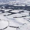
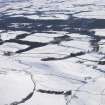
Settlement, Braidwood: Photographed by the RCAHMS in 1980.
(Undated) information in NMRS.
There is a small area of rig to the SW of the settlement on a small low promontory. The rig runs down towards Eight Mile Burn cottages.
Visited by RCAHMS (DE) 18 September 1994.
This settlement is situated on the crest of Camp Hill, 500m N of Braidwood farm. The results of small scale excavations, combined with survey, have revealed a complex sequence of structures, elements of which included two circuits of palisades and a pair of ditches with a medial rampart. The trench of the inner palisade, which is still visible on the ground for much of its course, encloses an oval area measuring 55m by 35m; the outer palisade, which was later incorporated into the rampart, lay at a distance of about 13m beyond the inner. Both palisades were interrupted by an entrance on the SW, but this relationship does not necessarily indicate that they were contemporary. The rampart was composed of material derived from the accompanying ditches, and there are also traces of a counterscarp bank around the W half of the perimeter. The main entrance of the settlement in the earthwork phase was again on the SW, and excavation has shown that the outer palisade trench curved inwards on each side of the gap, to form an entrance passage some 9m in length; other gaps occur on the NW and SE. Within the interior there are traces of a least sixteen houses, mostly of ring-ditch type; detailed examination of the relationship of the houses to the inner palisade suggests that there were at least three phases of construction, since some houses appear to be earlier, and others later, than the palisade trench. Excavation of two examples in 1947 revealed rings of post-holes within the ring-ditches; the finds included some sherds of pottery, a small stone ball and a fragemnt of glass armlet (RMS, HH486-9; see also HH 470-2 and 494-5). In the late 18th century a penannular twisted gold torc of Iron Age type (now lost) was found within the earthwork.
Wilson 1863; RCAHMS 1929; Stevenson 1949; Piggott 1958; DES (1968); MacGregor 1976; Feachem 1977; Hill 1982; Reynolds 1982.
Publication Account (1985)
On excavation Braidwood was found not to be a conventional hillfort but rather a timber palisaded settlement with secondary earthen banks, apparently unfinished (the outer bank is now almost ploughed out). With most earthen ramparts, the ditch lay on the outside with the cast earth within; here, however, the earlier palisades were used as outer retaining walls so that the new defences were dug from within-with the ditches, therefore, also within.
The earlier settlement is best described as a single wooden palisade enclosing an oval area of about 0.5 ha. The line of the bedding trench for this palisade is still visible on the ground as a shallow groove, and it was joined at its entrance to the second palisade, some 14m beyond, by connecting fences-providing a space between that might well have been used for impounding stock.
Also visible are traces of more than a dozen timberframed houses; they show up as circular or oval rings corresponding to the broad, shallow trenches in which the individual timber posts were set. Some of the houses may relate to the first period of settlement; those overlying the line of the palisade, however, must relate to the later phase and indicate a lengthy occupation span perhaps into the 1st or 2nd century AD. It should be remembered that the main Roman road from Carlisle and the Solway to Inveresk or Cramond on the Forth ran close to the east of the site, having passed through Annandale and Upper Clydesdale then round the south-east end of the Pentlands by Dolphinton and Carlops.
Information from 'Exploring Scotland's Heritage: Lothian and Borders', (1985).
Note (1988)
Braidwood NT 1928 5963 NT15NE 14
This settlement is situated on the crest of Camp Hill, 500m N of Braidwood farm. The results of small scale excavations, combined with survey, have revealed a complex sequence of structures, elements of which included two circuits of palisades and a pair of ditches with a medial rampart. The trench of the inner palisade, which is still visible on the ground for much of its course, encloses an oval area measuring 55m by 35m; the outer palisade, which was later incorporated into the rampart, lay at a distance of about 13m beyond the inner. Both palisades were interrupted by an entrance on the SW, but this relationship does not necessarily indicate that they were contemporary. The rampart was composed of material derived from the accompanying ditches, and there are also traces of a counterscarp bank around the W half of the perimeter. The main entrance of the settlement in the earthwork phase was again on the SW, and excavation has shown that the outer palisade trench curved inwards on each side of the gap, to form an entrance passage some 9m in length; other gaps occur on the NW and SE. Within the interior there are traces of at least sixteen houses, mostly of ring-ditch type; detailed examination of the relationship of the houses to the inner palisade suggests that there were at least three phases of construction, since some houses appear to be earlier, and others later, than the palisade trench. Excavation of two examples in 1947 revealed rings of post-holes within the ring-ditches; the finds included some sherds of pottery, a small stone ball and a fragment of glass armlet (RMS, HH 486-9; see also HH 470-2 and 494-5). In the late 18th century a penannular twisted gold tore of Iron Age type (now lost) was found within the earthwork.
RCAHMS 1988
(Wilson 1863, i, 465; RCAHMS 1929, 156-7, no. 206; Stevenson 1949; Piggott 1958; DES, 1968, 26; MacGregor 1976, i, 94, 113; ii, no. 190; Feachem 1977, 135-6; Hill 1982; Reynolds 1982)
Measured Survey (10 March 2015)
Braidwood prehistoric settlement was recorded by RCAHMS with UAV contractor Cyberhawk on 10 March 2015, as part of an RCAHMS research and design project to establish the strengths and weaknesses of 3D outputs from image-based modelling when compared with a detailed interpretative plan from 1993 produced with traditional methods. The survey involved the collection of 158 near vertical images and GNSS ground control.
Note (2 November 2015 - 25 October 2016)
This fort or fortified settlement is situated on the rounded summit of Camp Hill and has been surveyed and excavated on numerous occasions. Oval on plan, the visible defences comprise both earthworks and a palisade trench, but whether these were constructed sequentially or were conceived as elements in a single scheme is uncertain. The earthwork component comprises twin ditches with a medial rampart and an outer counterscarp bank, though in places the latter and the outer ditch have been reduced to little more than a terrace. There is no trace of an inner rampart, but lying between 4m and 6m behind the ditch there is a palisade trench, intermittently visible where it cuts through or is obliterated by some of the timber round-houses packed within the interior. The earthwork has entrances on the SE, SW and NW, but while that on the SW also served the palisaded enclosure in the interior, it is unclear whether there were corresponding gaps in the palisade at the other two. The palisade encloses an area measuring about 59m from NE to SW by 40m transversely (0.2ha), whereas the corresponding measurements for the areas enclosed by the inner ditch are 70m and 54m respectively (0.33ha). Traces of no fewer than twenty-five ring-ditch houses are visible sprawled across the area enclosed by the inner ditch, displaying a range of relationships in which they not only intersect their immediate neighbours, but also appear to cut or be cut by the palisade trench and the inner ditch. While this last relationship may have been caused by erosion along the inner lip of the ditch, the various elements of the perimeter and the houses they enclose evidently represent a complex sequence. Excavations carried out by Robert Stevenson and Kenneth Steer in 1940 and Stevenson again in 1947-8 (Stevenson 1949), the Edinburgh University Archaeological Society in 1951-3, and by George Watson's Archaeological Society in 1968 (Brown 1968), however, have done little to clarify either the sequence of enclosure or its date. While Stevenson concentrated on two of the ring-ditch houses, the other excavations focused on the SW entrance and the character of the defences. The medial rampart was found to be little more than a dump, which Stuart Piggott, writing up the excavations of the Edinburgh University work initially believed had been faced with timberwork set in a foundation trench, and linked to palisade trenches that formed a passage running up between the terminals of the rampart and the inner ditch at the SW entrance. The subsequent brief report of the section dug in 1968, however, for which Piggott's authority is also inferred, noted that the foundation trench lay beneath the rampart, but claimed that a 'low wall of packing stones' had been piled up against the outside of the timberwork before it was encased in the rampart; the conclusion was offered that the earthwork had adapted a free-standing palisade (Brown 1968). Apart from a gold torc said to have been found by a labourer trenching within the interior in the late 18th century (Wilson 1851, 318), finds from Stevenson's excavations include a fragment of a glass bangle, coarse pottery, stone balls and a perforated stone.
Information from An Atlas of Hillforts of Great Britain and Ireland – 25 October 2016. Atlas of Hillforts SC3695

