
Lochurd Farm


Farmhouse (Post Medieval), Farmstead (Post Medieval)
Site Name Lochurd Farm
Classification Farmhouse (Post Medieval), Farmstead (Post Medieval)
Canmore ID 50124
Site Number NT14SW 52
NGR NT 1135 4316
Datum OSGB36 - NGR
Permalink http://canmore.org.uk/site/50124


- Council Scottish Borders, The
- Parish Kirkurd
- Former Region Borders
- Former District Tweeddale
- Former County Peebles-shire
NT14SW 52 1135 4316.
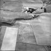
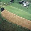
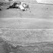
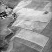
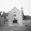
Lochurd Farm is described in the Name Book (ONB 1858-61) as a "well built farm house two storeys high with excellent offices, thrashing mill and farm attached". It is depicted as a grouping of five roofed buildings in a square setting on the 1st edition of the OS 6-inch map (Peeblesshire 1864, sheet vii). Air photographs (RCAHMSAP 1995) and the current 1:10000 map sheet (1992) show that three additional buildings have been added to the farm.
Information from RCAHMS (KB) 24 February 1995
Sbc Note
Visibility: This is an upstanding building.
Information from Scottish Borders Council.

