|
Photographs and Off-line Digital Images |
C 41865 |
RCAHMS Aerial Photography |
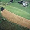
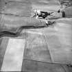
Lochurd, oblique aerial view, taken from the NNE, centred on the cropmarks of two possible enclosures, and showing Lochurd Farmsteading in the top left-hand corner of the photograph. |
22/6/1995 |
Item Level |
|
|
Photographs and Off-line Digital Images |
C 41866 |
RCAHMS Aerial Photography |
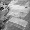
Lochurd, oblique aerial view, taken from the NW, centred on the cropmarks of two possible enclosures, and showing Lochurd Farmsteading in the top half of the photograph. |
22/6/1995 |
Item Level |
|
|
Photographs and Off-line Digital Images |
A 11834 |
List C Survey |
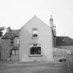
General view. |
1975 |
Item Level |
|
|
Photographs and Off-line Digital Images |
E 43967 |
RCAHMS Aerial Photography |
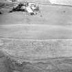
Oblique aerial view centred on the cropmarks of the fort with the farmsteading adjacent, taken from the SE. |
20/8/2004 |
Item Level |
|
|
Photographs and Off-line Digital Images |
E 50709 CN |
RCAHMS Aerial Photography |
Oblique aerial view centred on the cropmarks of the fort with the farmsteading adjacent, taken from the SE. |
20/8/2004 |
Item Level |
|
 |
On-line Digital Images |
SC 1629022 |
List C Survey |
General view. |
1975 |
Item Level |
|
 |
On-line Digital Images |
SC 1732428 |
RCAHMS Aerial Photography |
Oblique aerial view centred on the cropmarks of the fort with the farmsteading adjacent, taken from the SE. |
20/8/2004 |
Item Level |
|
 |
On-line Digital Images |
SC 1732437 |
RCAHMS Aerial Photography |
Oblique aerial view centred on the cropmarks of the fort with the farmsteading adjacent, taken from the SE. |
20/8/2004 |
Item Level |
|
 |
On-line Digital Images |
SC 1732524 |
RCAHMS Aerial Photography |
Lochurd, oblique aerial view, taken from the NNE, centred on the cropmarks of two possible enclosures, and showing Lochurd Farmsteading in the top left-hand corner of the photograph. |
22/6/1995 |
Item Level |
|
 |
On-line Digital Images |
SC 1732525 |
RCAHMS Aerial Photography |
Lochurd, oblique aerial view, taken from the NW, centred on the cropmarks of two possible enclosures, and showing Lochurd Farmsteading in the top half of the photograph. |
22/6/1995 |
Item Level |
|
 |
On-line Digital Images |
SC 2439202 |
Records of the Ordnance Survey, Southampton, Hampshire, England |
Lochurd Farm, NT14SW 52, Ordnance Survey index card, Recto |
1958 |
Item Level |
|


