 |
On-line Digital Images |
DP 080258 |
RCAHMS Aerial Photography Digital |
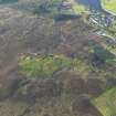
General oblique aerial view of The Ord, Lairg, taken from the SSW. |
29/5/2009 |
Item Level |
|
 |
On-line Digital Images |
SC 2347048 |
Records of the Ordnance Survey, Southampton, Hampshire, England |
Savalbeg, West, NC50NE 23, Ordnance Survey index card, page number 1, Recto |
c. 1958 |
Item Level |
|
|
All Other |
551 166/1/1 |
Records of the Ordnance Survey, Southampton, Hampshire, England |
Archaeological site card index ('495' cards) |
1947 |
Sub-Group Level |
|


