
Savalbeg, West


Clearance Cairn (Period Unassigned)
Site Name Savalbeg, West
Classification Clearance Cairn (Period Unassigned)
Canmore ID 4992
Site Number NC50NE 23
NGR NC 5937 0743
Datum OSGB36 - NGR
Permalink http://canmore.org.uk/site/4992


- Council Highland
- Parish Lairg
- Former Region Highland
- Former District Sutherland
- Former County Sutherland
NC50NE 23 5937 0743.
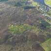
NC 5937 0743 An earth and stone mound about 10m in diameter and 1.2m high. On its west side there is a hollow 3m by 2m with a large boulder protruding at its side. This may be a cairn although there are clearance heaps in the area.
Surveyed at 1:2500.
Visited by OS (W D J) 27 June 1963.
This turf-covered stony mound, situated on a low rise within a field system (see NC50NE 34), is as described in the previous field report. There is insufficient evidence to classify it as a cairn, no kerb or cist can be seen, and the shape is somewhat irregular.
Visited by OS (N K B) 9 August 1976.

