|
Photographs and Off-line Digital Images |
PB 2061 |
RCAHMS Aerial Photography |
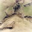
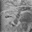
Oblique aerial view. |
1981 |
Item Level |
|
|
Photographs and Off-line Digital Images |
C 11938 CN |
RCAHMS Aerial Photography |
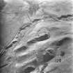
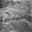
Oblique aerial view. |
1993 |
Item Level |
|
|
Photographs and Off-line Digital Images |
C 11936 CN |
RCAHMS Aerial Photography |
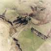
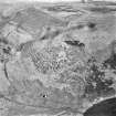
Oblique aerial view. |
1993 |
Item Level |
|
|
Photographs and Off-line Digital Images |
C 11935 CN |
RCAHMS Aerial Photography |
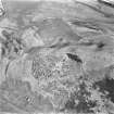
Oblique aerial view. |
1993 |
Item Level |
|
|
Photographs and Off-line Digital Images |
PB 2067 |
RCAHMS Aerial Photography |
Oblique aerial view. |
1981 |
Item Level |
|
|
Photographs and Off-line Digital Images |
PB 2068 |
RCAHMS Aerial Photography |
Oblique aerial view. |
1981 |
Item Level |
|
|
Photographs and Off-line Digital Images |
PB 2069 |
RCAHMS Aerial Photography |
Oblique aerial view. |
1981 |
Item Level |
|
|
Photographs and Off-line Digital Images |
PB 2070 |
RCAHMS Aerial Photography |
Oblique aerial view. |
1981 |
Item Level |
|
|
Photographs and Off-line Digital Images |
E 98470 CS |
RCAHMS Aerial Photography |
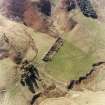
Oblique aerial view centred on the remains of the scooped homestead and fort with cultivation terraces, buildings and rig adjacent, taken from the ESE. |
2/5/2000 |
Item Level |
|
|
Photographs and Off-line Digital Images |
E 98472 CS |
RCAHMS Aerial Photography |
Oblique aerial view centred on the remains of the scooped homestead and fort with cultivation terraces, buildings and rig adjacent, taken from the E. |
2/5/2000 |
Item Level |
|
|
Photographs and Off-line Digital Images |
E 98471 CS |
RCAHMS Aerial Photography |
Oblique aerial view centred on the remains of the scooped homestead and fort with cultivation terraces, buildings, settlement and rig adjacent, taken from the E. |
2/5/2000 |
Item Level |
|
 |
On-line Digital Images |
SC 1731964 |
RCAHMS Aerial Photography |
Oblique aerial view. |
1993 |
Item Level |
|
 |
On-line Digital Images |
SC 1731987 |
RCAHMS Aerial Photography |
Oblique aerial view. |
1981 |
Item Level |
|
 |
On-line Digital Images |
SC 1732063 |
RCAHMS Aerial Photography |
Oblique aerial view. |
1993 |
Item Level |
|
 |
On-line Digital Images |
SC 1732064 |
RCAHMS Aerial Photography |
Oblique aerial view. |
1993 |
Item Level |
|
 |
On-line Digital Images |
SC 1732125 |
RCAHMS Aerial Photography |
Oblique aerial view. |
1981 |
Item Level |
|
 |
On-line Digital Images |
SC 1732126 |
RCAHMS Aerial Photography |
Oblique aerial view. |
1981 |
Item Level |
|
 |
On-line Digital Images |
SC 1732127 |
RCAHMS Aerial Photography |
Oblique aerial view. |
1981 |
Item Level |
|
 |
On-line Digital Images |
SC 1732128 |
RCAHMS Aerial Photography |
Oblique aerial view. |
1981 |
Item Level |
|
 |
On-line Digital Images |
SC 2438314 |
Records of the Ordnance Survey, Southampton, Hampshire, England |
Logan Knowes, NT12NW 41, Ordnance Survey index card, Recto |
c. 1958 |
Item Level |
|


