Walls
Moated Site (Medieval)
Site Name Walls
Classification Moated Site (Medieval)
Alternative Name(s) Frenchland; Rogermoor
Canmore ID 49717
Site Number NT10NW 11
NGR NT 1010 0602
Datum OSGB36 - NGR
Permalink http://canmore.org.uk/site/49717
- Council Dumfries And Galloway
- Parish Moffat
- Former Region Dumfries And Galloway
- Former District Annandale And Eskdale
- Former County Dumfries-shire
NT10NW 11 1010 0602.
(NT 1010 0602) Site of Walls (NR)
(Chapelry of Knights Templars) (NAT)
OS 6" map, (1898-1938)
Site of foundations of a number of houses - old writings show that 'Walls' was a Chapelry belonging to the Templars.
Name Book 1857
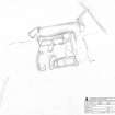
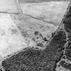
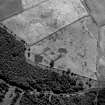
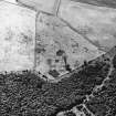
The remains of 'Walls' consist of the foundations of an almost rectangular grass-covered walled courtyard which measures c. 34.0m NE-SW by 32.0m transversely, with the wall-footings of a range of buildings lying along the inside of the N and S angle. A number of old field banks are traceable in the vicinity of the site. A massive earth - and - stone bank 6.6m broad and 1.2m high backs the N range of buildings on the S bank of a stream. Traces of a similar bank surmount the opposite bank of the stream. The construction of a sluiced pond in the stream behind the rear wall of the N range and the general plan and construction suggests that this is more than a relatively modern farmstead, but no documentary evidence could be found to substantiate the association with the Knights Templar, and it is possible that the site may have been confused with the remains at Chapel farm - NT 0739 0551 (NT00NE 11). However, there is considerable similarity between these remains and those of the monastic grange at Moorfoot (NT25SE 1), and therefore the site could reasonably be assumed to be at least a Medieval farmstead.
Surveyed at 1:2500.
Plan
Visited by OS (R D) 20 January 1972
Farmstead (NR)
OS 6" map, (1965).
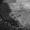
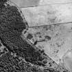
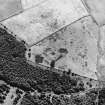
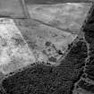
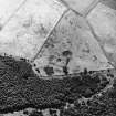
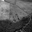
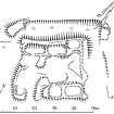
This probable moated site comprises two substantial two-compartment buildings, reduced to their grass-grown stone wall-footings, set on opposite sides of a yard and protected on the NNW and ENE by a ditch. The building on the SSE measures 22.7m by 7.2m overall; that on the NNW measures 23.7m by 6.7m overall, and at its ENE end there is a rectangular platform measuring 5.4m by 3.8m. The subdivided yard is closed on the ENE by the turf-covered footings of a stone wall and on the WSW by a severely wasted bank, whilst the entrance is in the S corner. The flat-bottomed ditch appears formerly to have been water-filled and is best preserved on the NNE, where it is 7.5m broad and 1.5m deep and accompanied by an internal bank 4.1m thick and 0.6m high; on the ENE it has been largely infilled. There are traces of a possible dam at the WNW terminal of the ditch, where a rectangular platform measuring 8.7m by 4.2m overall may indicate the site of a mill.
The remains are probably those of a moated site. Although the ditch can only be seen on two sides and may have been the pond for a mill, it almost certainly indicates the presence of a moated site.
The Name Book refers to the site as 'Walls' and states that it was 'a Chapelry belonging to the Templars'.
Visited by RCAHMS (PC), 29th August 1990
This site is listed in an Atlas of Scottish History (McNeill and MacQueen 1996) as a moated site.
Information from RCAHMS (DE) September 1997
Rogermoor. Listed as moated site.
RCAHMS 1997.
Measured Survey (18 March 1993)
RCAHMS surveyed Walls (Rogermoor) moated site with plane-table and self-reducing alidade at a scale of 1:250 on 29 August 1990. The plan was checked on site on 18 March 1993 and later redrawn in ink and published at a scale of 1:1000 (RCAHMS 1997, Fig. 219).
Field Visit (1996 - 2003)
Russell Coleman managed an Historic Scotland funded project to record medieval moated sites in Scotland. Gazetteers were produced for each regional council area between 1996 and 2002 with an uncompleted overall review in 2002-03. The results of the first year of the project were published in Tayside and Fife Archaeological Journal, Volume 3 (1997).
Note (1997)
NT 0529 0396 NT00SE 2
This site is listed in an Atlas of Scottish History (McNeill and MacQueen 1996) as a moated site.
Information from RCAHMS (DE) September 1997
Listed as moated site.
RCAHMS 1997.


