|
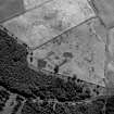
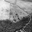
Photographs and Off-line Digital Images |
B 71680 |
RCAHMS Aerial Photography |
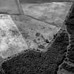
Aerial view. |
1991 |
Item Level |
|
|
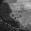
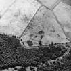
Photographs and Off-line Digital Images |
B 71681 |
RCAHMS Aerial Photography |
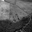
Aerial view. |
1991 |
Item Level |
|
|
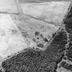
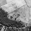
Photographs and Off-line Digital Images |
B 71682 |
RCAHMS Aerial Photography |
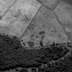
Aerial view. |
1991 |
Item Level |
|
|
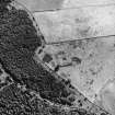
Photographs and Off-line Digital Images |
B 71683 |
RCAHMS Aerial Photography |
Aerial view. |
1991 |
Item Level |
|
|
Photographs and Off-line Digital Images |
B 71684 |
RCAHMS Aerial Photography |
Aerial view. |
1991 |
Item Level |
|
|
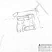
Prints and Drawings |
DC 32303 |
Records of the Royal Commission on the Ancient and Historical Monuments of Scotland (RCAHMS), Edinbu |
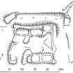
Survey drawing; Plan of moated site at Walls (Rogermoor). |
29/8/1990 |
Item Level |
|
|
Prints and Drawings |
DC 32286 |
Records of the Royal Commission on the Ancient and Historical Monuments of Scotland (RCAHMS), Edinbu |
Publication drawing; Plan of Walls (Rogermoor) moated site. |
15/3/1995 |
Item Level |
|
|
Prints and Drawings |
DC 32228 |
Records of the Royal Commission on the Ancient and Historical Monuments of Scotland (RCAHMS), Edinbu |
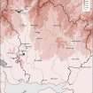
This map shows the distribution of timber and stone castles in Eastern Dumfriesshire and the neighbouring parts of Nithsdale and northern England. Published in Eastern Dumfriesshire: an archaeological landscape. |
1996 |
Item Level |
|
 |
On-line Digital Images |
SC 382037 |
Records of the Royal Commission on the Ancient and Historical Monuments of Scotland (RCAHMS), Edinbu |
Publication drawing; Plan of Walls (Rogermoor) moated site. |
15/3/1995 |
Item Level |
|
|
Prints and Drawings |
DC 44711 |
Records of the Royal Commission on the Ancient and Historical Monuments of Scotland (RCAHMS), Edinbu |
Plan |
1990 |
Item Level |
|
 |
On-line Digital Images |
SC 1148074 |
RCAHMS Aerial Photography |
Aerial view. |
1991 |
Item Level |
|
 |
On-line Digital Images |
SC 1148075 |
RCAHMS Aerial Photography |
Aerial view. |
1991 |
Item Level |
|
 |
On-line Digital Images |
SC 1148076 |
RCAHMS Aerial Photography |
Aerial view. |
1991 |
Item Level |
|
 |
On-line Digital Images |
SC 1148077 |
RCAHMS Aerial Photography |
Aerial view. |
1991 |
Item Level |
|
 |
On-line Digital Images |
SC 1148078 |
RCAHMS Aerial Photography |
Aerial view. |
1991 |
Item Level |
|
 |
On-line Digital Images |
SC 1345807 |
Records of the Royal Commission on the Ancient and Historical Monuments of Scotland (RCAHMS), Edinbu |
Survey drawing; Walls (Rogermoor) moated site. |
29/8/1990 |
Item Level |
|
 |
On-line Digital Images |
SC 1731888 |
RCAHMS Aerial Photography |
Aerial view. |
1991 |
Item Level |
|
 |
On-line Digital Images |
SC 1731889 |
RCAHMS Aerial Photography |
Aerial view. |
1991 |
Item Level |
|
 |
On-line Digital Images |
SC 1731890 |
RCAHMS Aerial Photography |
Aerial view. |
1991 |
Item Level |
|
 |
On-line Digital Images |
SC 1731891 |
RCAHMS Aerial Photography |
Aerial view. |
1991 |
Item Level |
|
 |
On-line Digital Images |
SC 1731892 |
RCAHMS Aerial Photography |
Aerial view. |
1991 |
Item Level |
|
|
Digital Files (Non-image) |
GV 007464 |
Records of the Royal Commission on the Ancient and Historical Monuments of Scotland (RCAHMS), Edinbu |
Map showing the distribution of timber and stone castles in Eastern Dumfriesshire and the neighbouring parts of Nithsdale and northern England. Published in Eastern Dumfriesshire: an archaeological landscape. |
1996 |
Item Level |
|
 |
On-line Digital Images |
SC 1917782 |
Records of the Royal Commission on the Ancient and Historical Monuments of Scotland (RCAHMS), Edinbu |
Map showing the distribution of timber and stone castles in Eastern Dumfriesshire and the neighbouring parts of Nithsdale and northern England. Published in Eastern Dumfriesshire: an archaeological landscape. |
1996 |
Item Level |
|
 |
On-line Digital Images |
SC 2438117 |
Records of the Ordnance Survey, Southampton, Hampshire, England |
Walls, NT10NW 11, Ordnance Survey index card, page number 1, Recto |
c. 1958 |
Item Level |
|


