|
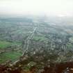
Photographs and Off-line Digital Images |
D 86077 CS |
RCAHMS Aerial Photography |
Graham's Dyke (Dean Road); a general aerial view taken from the E, centred c. 995 809. Dean Road probably follows the route of the Antonine Wall. |
5/2/1997 |
Item Level |
|
|
Photographs and Off-line Digital Images |
D 86078 CS |
RCAHMS Aerial Photography |
Graham's Dyke (Dean Road); a general aerial view taken from the E, centred c. 995 809. Dean Road probably follows the route of the Antonine Wall. |
5/2/1997 |
Item Level |
|
|
Photographs and Off-line Digital Images |
D 86079 CS |
RCAHMS Aerial Photography |
Graham's Dyke (Dean Road); a general aerial view taken from the E. centred c. 995 809. Dean Road probably follows the route of the Antonine Wall. |
5/2/1997 |
Item Level |
|
|
Photographs and Off-line Digital Images |
D 86080 CS |
RCAHMS Aerial Photography |
Graham's Dyke (Dean Road); a general aerial view taken from the E, centred c. 995 809. Dean Road probably follows the route of the Antonine Wall. |
5/2/1997 |
Item Level |
|
 |
On-line Digital Images |
SC 900333 |
RCAHMS Aerial Photography |
Oblique aerial view of Graham's Dyke (Dean Road) taken from the E, centred c. 995 809. Dean Road probably follows the route of the Antonine Wall. |
5/2/1997 |
Item Level |
|
|
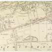
Photographs and Off-line Digital Images |
DC 47351/1 |
Records of the Ordnance Survey, Southampton, Hampshire, England |
Ordnance Survey 6-inch to the mile Provisional Edition, revision of Stirlingshire 1913 and West Lothian 1913-14 with additions 1938 & 1946.
Additional annotations by Ordnance Survey for the Antonine Wall map covering the Bo'ness area. |
c. 1948 |
Item Level |
|
 |
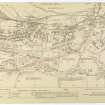
On-line Digital Images |
DP 051471 |
Records of the Royal Commission on the Ancient and Historical Monuments of Scotland (RCAHMS), Edinbu |
Antonine Wall Ordnance Survey 1954-57 working sheets map sheet 45 |
c. 1957 |
Item Level |
|
 |
On-line Digital Images |
DP 051472 |
Records of the Royal Commission on the Ancient and Historical Monuments of Scotland (RCAHMS), Edinbu |
Antonine Wall Ordnance Survey 1954-57 working sheets map sheet 46 |
c. 1957 |
Item Level |
|
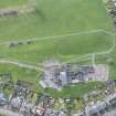 |
On-line Digital Images |
DP 249484 |
Historic Environment Scotland |
Oblique aerial view. |
24/3/2017 |
Item Level |
|
 |
On-line Digital Images |
SC 1970706 |
Records of Historic Scotland, Edinburgh, Scotland |
Antonine Wall 1:25000 broadsheet map |
2008 |
Item Level |
|
|
Digital Files (Non-image) |
GV 008531 |
Records of Historic Scotland, Edinburgh, Scotland |
Map showing the Antonine Wall, the World Heritage Site area, the areas of the World Heritage Site in public ownership or care, the Buffer Zone and the Council boundaries. Created for the World Heritage Site nomination - Management plan. |
2006 |
Item Level |
|
 |
On-line Digital Images |
SC 2170806 |
Records of Historic Scotland, Edinburgh, Scotland |
Map showing the Antonine Wall, the World Heritage Site area, the areas of the World Heritage Site in public ownership or care, the Buffer Zone and the Council boundaries. Created for the World Heritage Site nomination - Management plan. |
2006 |
Item Level |
|
 |
On-line Digital Images |
SC 2731113 |
Records of the Ordnance Survey, Southampton, Hampshire, England |
Bridgeness, NT08SW RRX 505, Ordnance Survey index card, Recto |
1958 |
Item Level |
|
 |
On-line Digital Images |
SC 2731114 |
Records of the Ordnance Survey, Southampton, Hampshire, England |
Bridgeness, NT08SW RRX 505, Ordnance Survey index card, Recto |
1958 |
Item Level |
|


