
Bridgeness, Antonine Wall


Frontier Defence (Roman)
Site Name Bridgeness, Antonine Wall
Classification Frontier Defence (Roman)
Alternative Name(s) Grahamsdyke Road
Canmore ID 49520
Site Number NT08SW 115
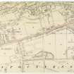
NGR NT 0078 8122
NGR Description From NT 0000 8107 to NT 0136 8150
Datum OSGB36 - NGR
Permalink http://canmore.org.uk/site/49520


- Council Falkirk
- Parish Bo'ness And Carriden
- Former Region Central
- Former District Falkirk
- Former County West Lothian
NT08SW 115 from NT 0000 8107 to NT 0136 8150
RRX 505 013 815
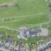
Excavation was carried out by Falkirk Museum on behalf of the HB and M along the OS line of the Antonine Wall in the vicinity of Bridgeness Tower, prior to the redevelopment of the area. Three trenches were cut. The most southerly of these hit bedrock immediately underlying the tennis courts, demonstrating the 'recent' terracing of the promontory. The second trench, to the N of the tennis courts, reached bedrock at a depth of 2.1m. Most of the over-burden was derived from the recent industrial use of the area but a distinct and continuous cultivation soil, some 40cm thick, lay immediately above bedrock. This contained no Roman material or structures and the bedrock had not been cut into. The third trench lay some 5m to the S of the find spot of the Legionary tablet. The area had been heavily disturbed in modern times, and no other stratigraphy was encountered.
A hand-dug trench was excavated immediately behind the monument commemmorating the discovery of the Bridgeness tablet, and adjacent to the find spot indicated on the OS maps. At a depth of 1.5m to 1.8m a layer of sandstone cobbling was bordered by a kerb of large squared stones and a length of drystone wall. Under the tumble from the wall 14th to 15th Century pottery was recovered. This would seem to indicate that the Legionary tablet had been brought to the site at a later date.
G B Bailey 1985.
NT 0000 8107 to NT 0136 8150 Ditch located pre-1925 (Macdonald 1925).
Published course (OS 25 inch 1972) accepted, although line slightly amended at Grange School to agree with NT 0123 8136.
No ground evidence was found to doubt this course or alignment angles.
NT 0136 8150 to NT 0137 8151 Published course (OS 25 inch 1972) amended to agree with findings of NT 0123 8136. New course, on slightly higher ground, still respects the approximate position of NT 0108 8131.
NT 0108 8131 Ditch located pre-1925 (approximate area) (Macdonald 1925).
NT 0123 8136 Excavation in November 1980 failed to locate the Wall or Ditch on the OS line. Course slightly to south suggested (Keppie and Breeze 1981).
NT 0214 8069 No evidence was found for a continuation of the Wall or Military Way from Bo'ness to Carriden fort. Should this have been so, the likeliest route of the Military Way is on or just S of the existing track, avoiding the steep sides of the Carriden Burn.
Information from OS 1980
L J F Keppie and D J Breeze 1981; G Macdonald 1925
Field Visit (1925)
NT 0000 8107 to NT 0136 8150 Ditch located pre-1925 (Macdonald 1925).
Field Visit (1925)
NT 0108 8131 Ditch located pre-1925 (approximate area) (Macdonald 1925).
Excavation (November 1980)
NT 0123 8136 Excavation in November 1980 failed to locate the Wall or Ditch on the OS line. Course slightly to south suggested (Keppie and Breeze 1981).
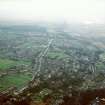
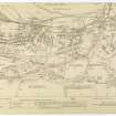
In November 1980, in advance of a housing development on waste ground at South Philpingstone
Lane in Bo'ness, trial trenching took place in search of the Antonine Wall, c 200 m SW of its presumed
starting point at Bridgeness. Current OS maps, on the authority of Sir George Macdonald, show the Wall
climbing SW from the Bridgeness promontory almost to Philpingstone Lane, then turning sharply to the
W towards Grange School and Grahamsdyke Road. This alignment was based on the discovery of the
edges of the ditch in a field c 100 m W of Philpingstone Lane (Macdonald 1925, 280; 1934, 100).
Excavation in 1980 on this supposed line proved entirely negative. Work was considerably hampered
by the foundations of now demolished houses bordering Philpingstone Lane on the N and
associated building debris. However, access to the undisturbed natural sand and gravel was obtained at
a sufficient number of points to preclude the presence of the ditch in the area examined. The search was
extended N of the supposed line for a further 25 m without success; it was evident that the ground contours
had been altered by the dumping of industrial waste materials at various times. Pottery manufacture
here or nearby in the 19th century was evidenced by the recovery of kiln furniture, spacers, and wasters
(C W McNay's Bridgeness Pottery was established in 1886 and closed sometime in the 1950s.) It may be
thought likely, therefore, that the Wall and ditch ran along somewhat higher ground to the S of Philpingstone
Lane, outwith the area examined in 1980, and turned NE towards Bridgeness promontory, near the
junction between the Lane and Harbour Road. It must be remembered, however, that the precise location
of the terminal point of the Wall on the River Forth remains a matter of some doubt.
Field Visit (1980)
NT 0000 8107 to NT 0136 8150 Published course (OS 25 inch 1972) accepted, although line slightly amended at Grange School to agree with NT 0123 8136.
No ground evidence was found to doubt this course or alignment angles.
Information from OS 1980
Field Visit (1980)
NT 0214 8069 No evidence was found for a continuation of the Wall or Military Way from Bo'ness to Carriden fort. Should this have been so, the likeliest route of the Military Way is on or just S of the existing track, avoiding the steep sides of the Carriden Burn.
Information from OS 1980
Field Visit (1980)
NT 0136 8150 to NT 0137 8151 Published course (OS 25 inch 1972) amended to agree with findings of NT 0123 8136. New course, on slightly higher ground, still respects the approximate position of NT 0108 8131.
Information from OS 1980
Excavation (September 1985)
Excavation was carried out by Falkirk Museum on behalf of the HB and M along the OS line of the Antonine Wall in the vicinity of Bridgeness Tower, prior to the redevelopment of the area. Three trenches were cut. The most southerly of these hit bedrock immediately underlying the tennis courts, demonstrating the 'recent' terracing of the promontory. The second trench, to the N of the tennis courts, reached bedrock at a depth of 2.1m. Most of the over-burden was derived from the recent industrial use of the area but a distinct and continuous cultivation soil, some 40cm thick, lay immediately above bedrock. This contained no Roman material or structures and the bedrock had not been cut into. The third trench lay some 5m to the S of the find spot of the Legionary tablet. The area had been heavily disturbed in modern times, and no other stratigraphy was encountered.
A hand-dug trench was excavated immediately behind the monument commemmorating the discovery of the Bridgeness tablet, and adjacent to the find spot indicated on the OS maps. At a depth of 1.5m to 1.8m a layer of sandstone cobbling was bordered by a kerb of large squared stones and a length of drystone wall. Under the tumble from the wall 14th to 15th Century pottery was recovered. This would seem to indicate that the Legionary tablet had been brought to the site at a later date.
G B Bailey 1985.
Magnetometry (23 January 2008 - 3 October 2008)
NT08SW 115 from NT 0000 8107 to NT 0136 8150
NT0035 8114. Geophysical survey. Modern (C19th and C20th) land use is likely to be responsible for all of the anomalies recorded by both survey techniques. In the gradiometer data it has given rise to large areas of severe magnetic disturbance which will have masked weaker responses from archaeological deposits (if any survive). The resistance results correspond well with the layout of paths of a former park, shown on 1940s/50s mapping.
C. Stephens
Earth Resistance Survey (23 January 2008 - 3 October 2008)
NT08SW 115 from NT 0000 8107 to NT 0136 8150
NT0035 8114. Geophysical survey. Modern (C19th and C20th) land use is likely to be responsible for all of the anomalies recorded by both survey techniques. In the gradiometer data it has given rise to large areas of severe magnetic disturbance which will have masked weaker responses from archaeological deposits (if any survive). The resistance results correspond well with the layout of paths of a former park, shown on 1940s/50s mapping.
C. Stephens
Magnetometry (April 2009 - October 2009)
NT 0200 8075 A magnetic survey was carried out, April–October 2009, in three locations to test the hypothesis that the Antonine Wall and associated ditch extended from Bridgeness to Carriden fort. The survey complements the trial trenching that Bailey previously undertook W of Carriden Brae. In the two 160m-long N–S transects at the W and E ends of the field S of West Lodge (NT08SW 8.01) no trace of the ditch was detected, and a similar negative result was recorded in the 200m-long N–S traverse between Carriden Glen and Old Manse Wood, some 350m E of the Old Manse (NT08SW 133). However, features which should be linked to probable coal pits and associated workings were noted in that transect.
Funder: EU Culture 2000: Frontiers of the Roman Empire project
R Jones 2009

