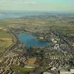
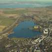
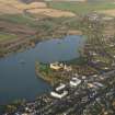
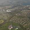
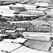
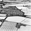
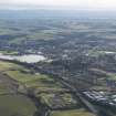
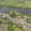
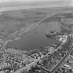
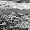
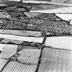
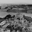
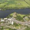
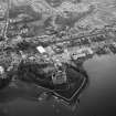
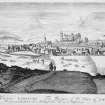
Accessibility

Font Size

100% 150% 200%

Background Colour

Default Contrast
Close Reset

Linlithgow, General

Burgh (Medieval) (1138), Town (Medieval)

Site Name Linlithgow, General

Classification Burgh (Medieval) (1138), Town (Medieval)

Canmore ID 49239

Site Number NT07NW 65

NGR NT 00220 77170

NGR Description Centred on NT 00220 77170

Datum OSGB36 - NGR

Permalink http://canmore.org.uk/site/49239

Ordnance Survey licence number AC0000807262. All rights reserved.
Canmore Disclaimer. © Bluesky International Limited 2025. Public Sector Viewing Terms

Toggle Aerial | View on large map

Digital Images

General oblique aerial view centred on the town, taken from the W.
General oblique aerial view centred on the town, taken from the W.General oblique aerial view centred on the town, taken from the SW.General oblique aerial view of the palace, taken from the SW.General oblique aerial view centred on the town, taken from the SW.General oblique aerial view of Avon Viaduct, taken from the S.Oblique aerial view centred on Linlithgow Palace.Aerial view.Aerial view.Oblique aerial view.Aerial view.Oblique aerial view centred on Linlithgow Palace.Aerial view.Aerial view.Aerial view.Aerial view.Aerial view.Aerial view.Oblique aerial view.Digital image of engraved view.General oblique aerial view centred on the W side of the town, taken from the WSW.General oblique aerial view of Linlithgow, taken from the WNW.General oblique aerial view of Linlithgow centred on Linlithgow Palace, taken from the ESE.Oblique aerial view centred on Linlithgow Palace.Aerial view.Aerial view.General oblique aerial view of Linlithgow, taken from the NW.Oblique aerial view centred on Linlithgow Palace.Aerial view.Aerial view.Aerial view.Drawing of trees with Linlithgow in background inscribed 'at Linlithgow 13 Sept 1838'.Elevated view from S.General oblique aerial view of the town centred on the palace with the coal mine and chemical works adjacent, taken from the NNE.General oblique aerial view centred on the W side of the town, taken from the S.Elevated view from S.Aerial view.Aerial view.Aerial view.Aerial view.General oblique aerial view of the town and palace, taken from the WSW.Aerial view.Aerial view.General view.General oblique aerial view of Avon Viaduct, taken from the SSW.General oblique aerial view of Linlithgow centred on Linlithgow Palace, taken from the SSE.Aerial view.Aerial view.Aerial view.Aerial view.Aerial view.Aerial view.Aerial view.Aerial view.Aerial view.Aerial view.Aerial view.General oblique aerial view of Linlithgow, taken from the NW.Engraving of distant view of Linlithgow.
Titled 'Linlithgow. London 1833 published by Charles Tilt, Fleet Street. Drawn by A. W. Callcot, R.A. Engraved by W. B. Cooke. Marmion.'Linlithgow, general view.
Titled: 'Linlithgow, from the railway station. 5026 G.W.W.'
PHOTOGRAPH ALBUM No.195: George Washington Wilson Album, p.120.Oblique aerial view centred on Linlithgow Palace.Aerial view.Aerial view.Aerial view.Aerial view.Aerial view.Aerial view.Aerial view.Aerial view.Aerial view.Oblique aerial view.Aerial view.Aerial view.Engraved general view.Floor plan.General oblique aerial view of the town centred on the palace, taken from the NNE.General oblique aerial view centred on the town, taken from the SE.General view across loch to Palace.Photographic copy of engraving showing general view.General oblique aerial view of Linlithgow, taken from the W.Oblique aerial view centred on Linlithgow Palace.Oblique aerial view centred on Linlithgow Palace.Aerial view.Aerial view.Aerial view.Aerial view.General oblique aerial view of the town and palace, taken from the W.Linlithgow, General, NT07NW 65, Ordnance Survey index card, Recto

Administrative Areas

  • Council West Lothian
  • Parish Linlithgow
  • Former Region Lothian
  • Former District West Lothian
  • Former County West Lothian

Archaeology Notes

NT07NW 65 00220 77170

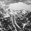
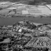
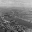
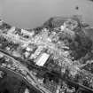
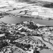
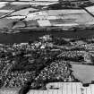
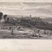
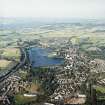
A royal burgh, created by David I c. 1138.

G S Pryde 1965; G G Simpson 1972.

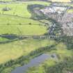
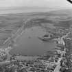
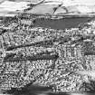
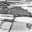
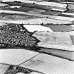
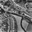
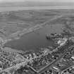
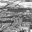
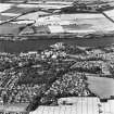
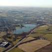
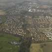
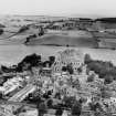
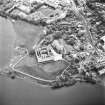
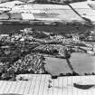
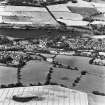
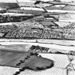
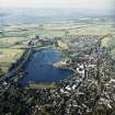
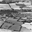
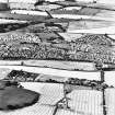
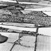
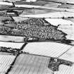
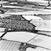
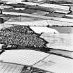
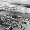
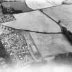
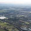
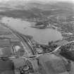
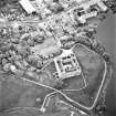
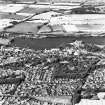
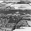
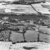
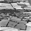
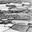
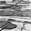
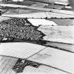
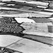
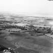
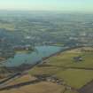
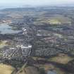
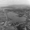
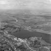
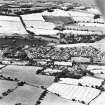
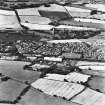
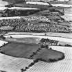
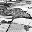
The central part of the town is visible on large scale vertical air photograph (OS 73/399/296, flown 1973)

Information from RCAHMS (RJCM) April 1992.

Architecture Notes

NT07NW 65 00220 77170

The location of Dunipace Cottage depicted in collection item LOR/L/57/1 cannot be confirmed at time of entry.

(AC 3 April 2002).

EXTERNAL RERFERENCE

Scottish Records Office

Accounts for building work on Lochurne bridge and on "the Norlage" (? Town clock of Linlithgow)

c. Early 17th century

Scottish Records Office

Linlithgow, school - Architect: Brown & Wardrop, 1863

Plans: RHP 9192 Brown & Wardrop 1863 - 4 plans, elevatios & sections.

National Library

Brown Collection Sketch Book no.24 NLS MS 508 2 sketches c. 1820

References

MyCanmore Image Contributions


Contribute an Image

MyCanmore Text Contributions