
Following the launch of trove.scot in February 2025 we are now planning the retiral of some of our webservices. Canmore will be switched off on 24th June 2025. Information about the closure can be found on the HES website: Retiral of HES web services | Historic Environment Scotland
Langloch Knowe


Cultivation Terrace(S) (Period Unassigned)
Site Name Langloch Knowe
Classification Cultivation Terrace(S) (Period Unassigned)
Canmore ID 48790
Site Number NT03SW 55
NGR NT 0442 3307
Datum OSGB36 - NGR
Permalink http://canmore.org.uk/site/48790


- Council South Lanarkshire
- Parish Culter
- Former Region Strathclyde
- Former District Clydesdale
- Former County Lanarkshire
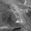
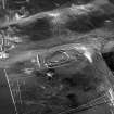
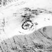
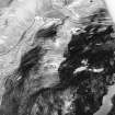
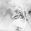
NT03SW 55 0442 3307.
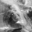
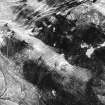
(NT 044 330) Fragments of three cultivation terraces can be seen on the S side of the Kilbucho-Culter track due N of the fort on Langloch Knowe (NT03SW 16).
Information from RCAHMS typescript, visited 1965.
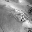
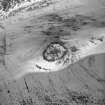
NT 0442 3307: Only one probable cultivation terrace was noted during investigation.
Visited by OS(DWR) 18 July 1972.

