|
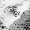
Photographs and Off-line Digital Images |
B 48739 |
RCAHMS Aerial Photography |
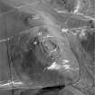
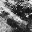
Oblique aerial view. |
1991 |
Item Level |
|
|
Photographs and Off-line Digital Images |
B 48740 |
RCAHMS Aerial Photography |
Oblique aerial view. |
1991 |
Item Level |
|
|
Photographs and Off-line Digital Images |
B 48746 |
RCAHMS Aerial Photography |
Oblique aerial view. |
1991 |
Item Level |
|
|
Photographs and Off-line Digital Images |
B 48747 |
RCAHMS Aerial Photography |
Oblique aerial view. |
1991 |
Item Level |
|
|
Photographs and Off-line Digital Images |
B 48748 |
RCAHMS Aerial Photography |
Oblique aerial view. |
1991 |
Item Level |
|
|
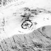
Photographs and Off-line Digital Images |
C 55650 |
RCAHMS Aerial Photography |
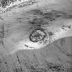
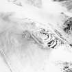
Cow Castle, oblique aerial view, taken from the NW, centred on a fort and settlement site, with Langloch Knowe fort and cultivation terraces to the top of the photograph. |
22/2/1996 |
Item Level |
|
|
Photographs and Off-line Digital Images |
C 55651 |
RCAHMS Aerial Photography |
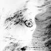
Cow Castle, oblique aerial view, taken from the WSW, centred on a fort and settlement site, with Nisbet settlement site and cultivation terraces to the top of the photograph. |
22/2/1996 |
Item Level |
|
|
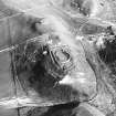
Photographs and Off-line Digital Images |
C 55652 |
RCAHMS Aerial Photography |
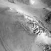
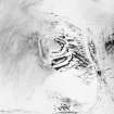
Langloch Knowe, oblique aerial view, taken from the NW, centred on cultivation terraces with a fort to the left of the photograph. |
22/2/1996 |
Item Level |
|
|
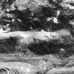
Photographs and Off-line Digital Images |
C 55653 |
RCAHMS Aerial Photography |
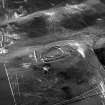
Langloch Knowe, oblique aerial view, taken from the W, centred on cultivation terraces and a fort. |
22/2/1996 |
Item Level |
|
|
Photographs and Off-line Digital Images |
C 55654 |
RCAHMS Aerial Photography |
Langloch Knowe, oblique aerial view, taken from the W, centred on cultivation terraces and a fort, with another fort and settlement to the left of the photograph. |
22/2/1996 |
Item Level |
|
|
Photographs and Off-line Digital Images |
C 55655 |
RCAHMS Aerial Photography |
Langloch Knowe, oblique aerial view, taken from the E, centred on cultivation terraces and a fort. |
22/2/1996 |
Item Level |
|
 |
On-line Digital Images |
SC 573018 |
RCAHMS Aerial Photography |
Oblique aerial view. |
1991 |
Item Level |
|
 |
On-line Digital Images |
SC 573022 |
RCAHMS Aerial Photography |
Scanned image of an oblique aerial view. |
1991 |
Item Level |
|
 |
On-line Digital Images |
SC 573024 |
RCAHMS Aerial Photography |
Scanned image of an oblique aerial view, taken from the WSW, centred on a fort and settlement site, with Nisbet settlement site and cultivation terraces to the top of the photograph. |
22/2/1996 |
Item Level |
|
 |
On-line Digital Images |
SC 624036 |
RCAHMS Aerial Photography |
Cow Castle, oblique aerial view, taken from the NW, centred on a fort and settlement site, with Langloch Knowe fort and cultivation terraces to the top of the photograph. |
22/2/1996 |
Item Level |
|
 |
Digital Files (Non-image) |
WP 003392 |
Records from Biggar Museum Trust, Biggar, South Lanarkshire, Scotland |
Report on the archaeological sites and monuments on Nisbet Farm, Coulter, South Lanarkshire |
3/2004 |
Item Level |
|
 |
On-line Digital Images |
SC 1730394 |
RCAHMS Aerial Photography |
Oblique aerial view. |
1991 |
Item Level |
|
 |
On-line Digital Images |
SC 1730395 |
RCAHMS Aerial Photography |
Oblique aerial view. |
1991 |
Item Level |
|
 |
On-line Digital Images |
SC 1730401 |
RCAHMS Aerial Photography |
Oblique aerial view. |
1991 |
Item Level |
|
 |
On-line Digital Images |
SC 1730402 |
RCAHMS Aerial Photography |
Oblique aerial view. |
1991 |
Item Level |
|
 |
On-line Digital Images |
SC 1730403 |
RCAHMS Aerial Photography |
Oblique aerial view. |
1991 |
Item Level |
|
 |
On-line Digital Images |
SC 1730470 |
RCAHMS Aerial Photography |
Cow Castle, oblique aerial view, taken from the WSW, centred on a fort and settlement site, with Nisbet settlement site and cultivation terraces to the top of the photograph. |
22/2/1996 |
Item Level |
|
 |
On-line Digital Images |
SC 1730471 |
RCAHMS Aerial Photography |
Langloch Knowe, oblique aerial view, taken from the NW, centred on cultivation terraces with a fort to the left of the photograph. |
22/2/1996 |
Item Level |
|
 |
On-line Digital Images |
SC 1730472 |
RCAHMS Aerial Photography |
Langloch Knowe, oblique aerial view, taken from the W, centred on cultivation terraces and a fort. |
22/2/1996 |
Item Level |
|


