
Pricing Change
New pricing for orders of material from this site will come into place shortly. Charges for supply of digital images, digitisation on demand, prints and licensing will be altered.
Urchin Knowe


Building(S) (Post Medieval), Cairnfield (Prehistoric), Enclosure(S) (Post Medieval), Field Boundary(S) (Post Medieval), Hut (Post Medieval)
Site Name Urchin Knowe
Classification Building(S) (Post Medieval), Cairnfield (Prehistoric), Enclosure(S) (Post Medieval), Field Boundary(S) (Post Medieval), Hut (Post Medieval)
Canmore ID 48505
Site Number NT01SW 4
NGR NT 028 120
Datum OSGB36 - NGR
Permalink http://canmore.org.uk/site/48505


- Council Dumfries And Galloway
- Parish Moffat
- Former Region Dumfries And Galloway
- Former District Annandale And Eskdale
- Former County Dumfries-shire
(A: NT 0278 1193; B: NT 0280 1193; C: NT 0282 1193) Hut Circles (NR)
OS 6" map, (1962)
Three hut circles lie on the gentle N slopes of Harthope Bank. 'A', the westernmost, is a turf-banked enclosure measuring 4.0m in diameter overall. 'B', 15.0m NE of 'A', is 5.0m in diameter, while 'C', 25.0m E of 'B', is 5.2m in diameter overall. Their enclosing banks are spread to 0.9m and are 0.2m high. No entrances were noted.
Visited by OS (W D J) 11 August 1959
NT 028 120: Within an area of pasture and rough ground is a group of several clearance heaps of modern appearance with no trace of connecting lynchets. There are also four or five circular turf-walled enclosures, about 5.0m in diameter overall, and the footings of two rectangular buildings.
None of the features in this area is of any great age and all are probably part of a post-medieval farm complex.
The northernmost of the three 'hut circles' has been destroyed by the construction of a hill road.
Information from: OS Rev 24 August 1982.
Measured Survey (19 November 1991)
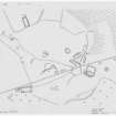
RCAHMS surveyed the buildings and field-system at Urchin Knowe on 19 November 1991 with plane-table and self-reducing alidade at a scale of 1:500. The plan was redrawn in ink and published at a scale of 1:1000 (RCAHMS 1997, Fig. 38).
Field Visit (June 1992)
NT01SW 4.00 028 120.
NT01SW 4.01 centred 028 120 Field-system; Small Cairns
NT01SW 4.02 0290 1204 Building; Enclosure; Pen
NT01SW 4.03 0288 1204 Enclosure
NT01SW 4.04 0282 1202 Building
NT01SW 4.05 0289 1206 Buildings
NT01SW 4.06 0289 1207 Building
NT01SW 4.07 0287 1207 Hut
NT01SW 4.08 0281 1211 Building
NT01SW 4.09 0283 1213 Building; Enclosure
NT01SW 4.10 0274 1207 Building
For enclosure on the ENE flank of Urchin Knowe (NT 0296 1221), see NT01SW 7.
Disposed over the ground on the S, SE, and E sides of Urchin Knowe, there are the remains of at least nine buildings, three enclosures, a field-system defined by turf banks, and at least forty-seven clearance cairns, some of which are quite substantial.
Visited by RCAHMS (IMS) June 1992.
Listed as cairnfield, buildings and hut.
RCAHMS 1997.

