
Port Odhar


Landing Point (Period Unassigned)
Site Name Port Odhar
Classification Landing Point (Period Unassigned)
Alternative Name(s) Balnakeil Bay
Canmore ID 4850
Site Number NC37SE 2
NGR NC 358 709
Datum OSGB36 - NGR
Permalink http://canmore.org.uk/site/4850


- Council Highland
- Parish Durness
- Former Region Highland
- Former District Sutherland
- Former County Sutherland
NC37SE 2 NC 358 709.
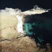
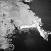
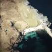
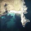
The site is a naturally sheltered pebble beach used for the landing of boats.
Lieu 2000, 2.
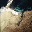
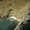
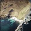
Port Odhar is a natural harbour. Although it is on the headland of the Kyle of Durness it is sheltered by a spit of land to the North and is visually quite deep. Such a site is capable of drawing a large enough body of water to land a sizeable boat. No evidence of any artificial landing stage could be found to suggest the presence of an artificial harbour. However given the natural formation of the area one may not have been necessary.
Street 2001, 10.
Field Visit (2008)
Port Odhar is a SE-facing cove with a sand beach, which is situated on the W side of the broad entrance to the Kyle of Durness. The steep natural slopes on the SW and the finger of limestone that forms a natural breakwater on the NW provide some degree of shelter to vessels. Although there is no evidence of there ever have been a pier or slipway here, the shallow nature of the cove provides a comparatively safe landing-place for boats.
Port Odhar is one of two safe havens depicted, although it is not named, west of the Kyle of Durness on a mid-18th century coastal chart (Bryce and Cooper, c.1744). The other haven shown is the Bay of Kearvaig (NC 290729), which is the only other sandy beach on this section of coast.
Visited by RCAHMS (JRS, JH) 10 August 2008.

